Minami-ku, Saitama
| Minami-ku, Saitama 南区 | |
|---|---|
| Ward | |
| Minami Ward | |
|
Minami Ward Office, Saitama City | |
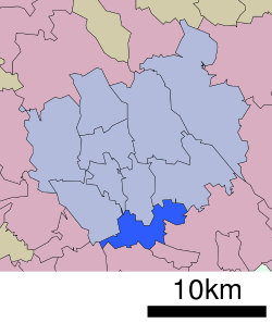 Location of Minami-ku in Saitama | |
 Minami-ku, Saitama
| |
| Coordinates: 35°50′42″N 139°38′43″E / 35.84500°N 139.64528°ECoordinates: 35°50′42″N 139°38′43″E / 35.84500°N 139.64528°E | |
| Country | Japan |
| Region | Kanto |
| Prefecture | Saitama |
| City | Saitama |
| Area | |
| • Total | 13.82 km2 (5.34 sq mi) |
| Population (February 2016) | |
| • Total | 180,558 |
| • Density | 13,060/km2 (33,800/sq mi) |
| Time zone | Japan Standard Time (UTC+9) |
| -Flower | Sunflower |
| Phone number | 048-835-3156 |
| Address |
7-20 Bessho, Minami-ku, Saitama-shi, Saitama-ken 338-0002 |
| Website |
www |

Minami-ku (南区 Minami-ku) is one of ten wards of the city of Saitama, in Saitama Prefecture, Japan, and is located in the northern part of the city. As of 1 February 2016, the ward had an estimated population of 180,558 and a population density of 13,060 persons per km². Its total area was 13.82 square kilometres (5.34 sq mi).
Geography
Minami Ward is within the Kanto plain, with a minimum altitude of 2.9 meters and maximum altitude of 16.9 meters above sea level. The Arakawa River and several others drain the area. Minami Ward has three bodies of water: Besshonuma, Shirahatanuma, and Saiko. Approximately 56% of the area was of the ward is residential area and less than 5% was rural; consequently the entire ward was designated a "densely inhabited district" (DID) in 2005.
Neighboring Municipalities
Saitama Prefecture
History
The villages of Mutsuji, Yada, Tsuchiai and Miyamoto were created within Kitaadachi District, Saitama with the establishment of the municipalities system on April 1, 1889. On April 1, 1932 Yada and the village of Kisaki (also from Kitaadachi District)] were annexed by Urawa Town. On February 11, 1934, Urawa was raised to city status. Mutsuji was elevated to town status on 1938 and was annexed by Urawa on April 1, 1942. In 1943, Miyamoto merged with the neighboring village of Sasame and was renamed Misasa. On January 1, 1955 the village of Tsuchiai and the village of Okubo (also from Kitaadachi District) were annexed by Urawa. In 1957, the village of Misasa was merged with the town of Toda, but due to strong local opposition, most of the village was transferred to Urawa in 1959. On May 1, 2001 the cities of Urawa, Yono and Ōmiya merged to form the new city of Saitama. When Saitama was proclaimed a designated city in 2003, the much area of corresponding to former villages of Mutsuji, Yada, Tsuchiai and Miyasasa became Minami Ward.
Education
- Minami-ku has 14 elementary schools, eight middle schools, and four high schools.
Transportation
Railway
Highway
Local attractions
Many facilities are located in Minami-ku. The city has a culture center. There are two public parks, a horse-racing track, and a swimming pool, which in winter serves as a skating rink. Minami-ku is home to Lotte Urawa Stadium, second home field of the Chiba Lotte Marines baseball team. A theme park, Musashi Urawa Ramen Academy, is in the ward.
External links
| Wikimedia Commons has media related to Minami-ku, Saitama. |
Official website (Japanese)
| Wards of Saitama | ||
|---|---|---|
| Core cities | ||
| Special cities | ||
| Cities | ||
| Chichibu District | ||
| Hiki District | ||
| Iruma District | ||
| Kitaadachi District | ||
| Kitakatsushika District | ||
| Kodama District | ||
| Minamisaitama District | ||
| Ōsato District | ||