Kazo, Saitama
| Kazo 加須市 | |||
|---|---|---|---|
| City | |||
|
Kazo City Hall | |||
| |||
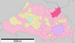 Location of Kazo in Saitama Prefecture | |||
 Kazo Location of Kazo in Saitama Prefecture | |||
| Coordinates: 36°7′53.2″N 139°36′6.4″E / 36.131444°N 139.601778°ECoordinates: 36°7′53.2″N 139°36′6.4″E / 36.131444°N 139.601778°E | |||
| Country | Japan | ||
| Region | Kantō | ||
| Prefecture | Saitama Prefecture | ||
| Area | |||
| • Total | 133.30 km2 (51.47 sq mi) | ||
| Population (February 2016) | |||
| • Total | 112,158 | ||
| • Density | 84/km2 (220/sq mi) | ||
| Time zone | Japan Standard Time (UTC+9) | ||
| - Tree | Sakura | ||
| - Flower | Cosmos | ||
| Phone number | 0480-62-1111 | ||
| Address | 2-1-1 Mitsumata, Kazo-shi, Saitama-ken 347-8501 | ||
| Website | Official website | ||


Kazo (加須市 Kazo-shi) is a city located in Saitama Prefecture, in the central Kantō region of Japan. As of 1 February 2016, the city had an estimated population of 112,158 and a population density of 841 persons per km². Its total area was 133.30 square kilometres (51.47 sq mi). The city is noted for is known throughout Japan for the creation of koinobori (carp kites), baseballs, kendo equipment, and Kazo-udon noodles.
Geography
Kazo is located in far northeastern Saitama Prefecture, bordered by Gunma Prefecture, Tochigi Prefecture and Ibaraki Prefectures along the alluvial plain of the Watarase River and Tone River.
Surrounding municipalities
History
The area of modern Kazo has been settled since prehistoric times and many burial mounds from the Kofun period dot the landscape. The name "Kazo" appears in Nara period documents describing within Musashi Province. During the Edo period, the Buddhist temple of Sogan-ji was a popular pilgrimage destination from Edo.
The town of Kazo was created within Kitasaitama District, Saitama with the establishment of the municipalities system on April 1, 1889. On May 3, 1954, Kazo annexed the neighboring town of Fudooka, and the villages of Mitsumata, Raiha, Ōkuwa, Mizufuka, Hirakikawa and Shidai and was elevated to city status.
On March 23, 2010, Kazo absorbed the towns of Kisai, Kitakawabe and Ōtone (all from Kitasaitama District) which was dissolved as a result of this merger.
Economy
- The computer graphics tablet manufacturer, Wacom is headquartered in Kazo.
Education
- Heisei International University
- Kazo has 22 elementary schools, eight middle schools and two high schools.
Transportation
Railway
Highway
Noted people from Kazo
- Yutaka Taniyama, mathematician
External links
| Wikimedia Commons has media related to Kazo, Saitama. |
- Official website (Japanese)
| Wards of Saitama | ||
|---|---|---|
| Core cities | ||
| Special cities | ||
| Cities | ||
| Chichibu District | ||
| Hiki District | ||
| Iruma District | ||
| Kitaadachi District | ||
| Kitakatsushika District | ||
| Kodama District | ||
| Minamisaitama District | ||
| Ōsato District | ||