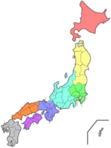
Saitama Prefecture
| Saitama Prefecture 埼玉県 | |||
|---|---|---|---|
| Prefecture | |||
| Japanese transcription(s) | |||
| • Japanese | 埼玉県 | ||
| • Rōmaji | Saitama-ken | ||
| |||
 | |||
| Coordinates: 35°57′N 139°33′E / 35.950°N 139.550°ECoordinates: 35°57′N 139°33′E / 35.950°N 139.550°E | |||
| Country | Japan | ||
| Region | Kantō | ||
| Island | Honshu | ||
| Capital | Saitama | ||
| Government | |||
| • Governor | Kiyoshi Ueda | ||
| Area | |||
| • Total | 3,798.08 km2 (1,466.45 sq mi) | ||
| Area rank | 39th | ||
| Population (October 1, 2014) | |||
| • Total | 7,237,734 | ||
| • Rank | 5th | ||
| • Density | 1,893.82/km2 (4,905.0/sq mi) | ||
| ISO 3166 code | JP-11 | ||
| Districts | 8 | ||
| Municipalities | 63 | ||
| Flower | Primrose (Primula sieboldii) | ||
| Tree | Keyaki (Zelkova serrata) | ||
| Bird | Eurasian collared dove (Streptopelia decaocto) | ||
| Website |
www | ||


Saitama Prefecture (埼玉県 Saitama-ken) is a landlocked prefecture of Japan located in the Kantō region of the island of Honshu.[1] The capital is the city of Saitama.[2]
This prefecture is part of the Greater Tokyo Area, and most of Saitama's cities can be described as suburbs of Tokyo, to which a large number of residents commute each day.
History
According to Sendai Kuji Hongi (Kujiki), Chichibu was one of 137 provinces during the reign of Emperor Sujin.[3] Chichibu Province was in Saitama's western part.
Saitama Prefecture was formerly part of the old Musashi Province.[4]
In the fifth year of the Keiun era (708), deposits of copper were reported to have been found in the Chichibu District of what is now Saitama Prefecture.
The Saitama area was historically known as a fertile agricultural region which produced much of the food for the Kantō region. During the Edo period, many fudai daimyo ruled small domains within the Saitama area.
After World War II, as Tokyo expanded rapidly and modern transportation allowed longer commutes, the lack of available land in Tokyo led to the rapid development of Saitama Prefecture, whose population has nearly tripled since 1960. Most of the cities in the prefecture are closely connected to downtown Tokyo by metropolitan rail, and operate largely as residential and commercial suburbs of Tokyo.
Geography

Saitama Prefecture is bordered by Tokyo, Chiba, Ibaraki, Tochigi, Gunma, Nagano, and Yamanashi Prefectures. It is located central-west of the Kanto region, measuring 103 km from east to west and 52 km from north to south. At 3,798 km2, it ranks as the ninth-smallest prefecture. The eastern border with Chiba Prefecture is defined by the Edo River. The northern and north-western border lines with Gunma Prefecture are marked by the Tone River and the Kanagawa River and the drainage divides of the Arakawa River and Kanagawa River. The southwestern border is defined by the drainage divides of the Arakawa River, Tama River, and Fuefuki River. The eastern section of the southern border line, however, does not overlap with any geological feature.
The topography of Saitama Prefecture is largely divided by the Hachiōji Tectonic Line, which runs through Kodama, Ogawa, and Hannō, into the western mountain area and the eastern lowland area. The altitude, highest on the western side, gradually lowers eastward from mountain ranges to hills to plateaus to lowlands. The eastern lowlands and plateaus occupy 67.3% of the area.[5]
The eastern side, part of the Kantō Plain, can be further divided into nine separate expanses of hills and ten plateaus. The former occupy small areas neighboring the Kantō Mount Range, including the Hiki Hills and Sayama Hills. The latter are mainly surrounded by alluvial flood plains. In the southeastern portion of the prefecture, the Ōmiya Plateau stands in a southeastward direction, sandwiched by the Furutone River to the east and the Arakawa River to the west.[6]
The western side of the prefecture belongs to the Kantō Mountain Range with Chichibu Basin located in its center. The area to the west of the basin features high peaks such as Mount Sanpō (2,483 m) and Mount Kōbushi (2,475 m), in which the Arakawa River has its source. Most of the land is contained in Chichibu Tama Kai National Park. The area to east of the basin consists of relatively low mountains.
Cities
Forty cities are located in Saitama Prefecture:
Towns and villages
These are the towns and villages in each district:
Mergers
Transportation
Radial transportation to and from Tokyo dominates transportation in the prefecture. Circular routes were constructed as bypasses to avoid congestion in central Tokyo.
Roads
The Jōban, Kan-etsu, Shuto, Tōhoku, and Tokyo-Gaikan expressways form parts of the nationwide expressway network. National highway Routes 4, 16, and 17 are important routes in Kantō region.
Railways
Ōmiya Station in Saitama City forms East Japan Railway Company's northern hub station in the Greater Tokyo Area, offering transfers to and from Shinkansen high-speed lines. The Musashino serves as a freight bypass line as well as a passenger line. Chichibu Railway the northwestern, Seibu Railway the southwestern, Tobu Railway the midwestern and the eastern, the New Shuttle and Saitama Railway the southeastern parts of the prefecture respectively. The Tsukuba Express line crosses the southeastern corner of the prefecture.
- East Japan Railway Company
- Tobu
- Seibu
- Tokyo Metro
- Tsukuba Express
- Saitama Rapid Railway Line
- Chichibu Railway
- Chichibu Mainline
- Mikajiri Line
People movers
- Saitama New Urban Transit (New Shuttle)
- Seibu Yamaguchi Line (Leo Liner)
Airports
Haneda Airport and Narita International Airport are the closest major civil airports. Commuter helicopter flights from Kawajima to Narita Airport are offered.[7]
Honda Airport for general aviation and the JASDF's Iruma Air Base,[8] and Kumagaya[9]
Waterways
Rivers and canals, including those developed in the Edo period (17th - 19th centuries) in the east of the prefecture, are largely disused following the introduction of motorised land transport. Traces of water transport are found on the Tone River, which forms the border between Saitama and Gunma Prefecture, and on the Arakawa River, which includes a tourist attraction in Nagatoro.[10]
Culture
Mass media
See Mass media in Saitama Prefecture.
Sister relationships
Saitama Prefecture has a number of sister city relationships with states and a province as listed below (in chronological order).[11]
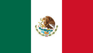 Mexico State, Mexico, affiliated on October 2, 1979
 Shanxi province,China, affiliated on October 27, 1982
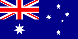 Queensland, Australia, affiliated on October 27, 1984
 Ohio, United States, affiliated on October 22, 1990
 Brandenburg, Germany, affiliated on August 26, 1998
Sports
The sports teams listed below are based in Saitama.
Football (soccer)
Baseball
Basketball
Volleyball
Rugby
Tourism
Most of the popular tourist sites in Saitama are located in the northwestern part of the prefecture, which is known as the Chichibu Region. This region mostly consists of a hilly and moderately mountainous area, and is situated in a rich natural environment. The region is very popular among residents of Saitama and neighboring prefectures for short trips, as it is easily accessible via the railroad network.
Visitor attractions
|
Mascot
Kobaton (コバトン) is the prefectural mascot, a Eurasian collared dove, which is also the prefectural bird. Kobaton was made originally as the mascot of the fifty-ninth annual national athletic meeting held in the prefecture in 2004, and was inaugurated as mascot of the prefecture in 2005 with an inauguration ceremony and a letter of appointment from the governor. A wheelchair-using version of Kobaton also exists.[12]
See also
- Saitama Bank
- Sayama Tea, a tea variety grown in Saitama prefecture
- Thirteen Buddhas of Chichibu
Notes
- ↑ Nussbaum, Louis-Frédéric. (2005). "Saitama prefecture" in Japan Encyclopedia, p. 808, p. 808, at Google Books; "Kantō" in p. 479, p. 479, at Google Books.
- ↑ Saitama City Profile, overview
- ↑ Enbutsu, Sumiko. (1990). Chichibu: Japan's hidden treasure, p. 13.
- ↑ Nussbaum, "Provinces and prefectures" at p. 780, p. 780, at Google Books.
- ↑ 埼玉県総務部広聴広報課 (2008-02-06). "埼玉県/彩の国わくわくこどもページ/県のあらまし/土地・気象". Web.archive.org. Archived from the original on 2008-02-06. Retrieved 2010-12-07.
- ↑ "地形と歴史". Web.archive.org. 2004-09-28. Archived from the original on 2004-09-28. Retrieved 2010-12-07.
- ↑ "Connecting TOKYO and Narita Int'l Airport - NARITA HELI EXPRESS". Heli-express.com. Retrieved 2010-12-07.
- ↑ "航空自衛隊入間基地". Mod.go.jp. Retrieved 2010-12-07.
- ↑ "航空自衛隊熊谷基地". Mod.go.jp. Retrieved 2010-12-07.
- ↑ as of 2007-06-20.
- ↑ "Sister States and Provinces of Saitama Prefecture". Saitama Prefecture. 1 July 2011. Retrieved 17 June 2012.
- ↑ 埼玉県総務部広聴広報課 (2008-02-21). "埼玉県/埼玉県のマスコット コバトン". Web.archive.org. Archived from the original on 2008-02-21. Retrieved 2010-12-07.
References
- Nussbaum, Louis-Frédéric and Käthe Roth. (2005). Japan encyclopedia. Cambridge: Harvard University Press. ISBN 978-0-674-01753-5; OCLC 58053128
External links
| Wikimedia Commons has media related to Saitama prefecture. |
- Official website
- Official YouTube channel (Japanese)
| Wards of Saitama | ||
|---|---|---|
| Core cities | ||
| Special cities | ||
| Cities | ||
| Chichibu District | ||
| Hiki District | ||
| Iruma District | ||
| Kitaadachi District | ||
| Kitakatsushika District | ||
| Kodama District | ||
| Minamisaitama District | ||
| Ōsato District | ||