Mount Pleasant Historic District (Mount Pleasant, North Carolina)
|
Mount Pleasant Historic District | |
|
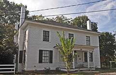
Daniel Dixon Barrier House, (c. 1858), | |
  | |
| Location | Roughly W. and E. Franklin between N. Halifax and C and N and N. and S. Main Sts. between Boston and Broad Sts., Mount Pleasant, North Carolina |
|---|---|
| Coordinates | 35°24′8″N 80°26′06″W / 35.40222°N 80.43500°WCoordinates: 35°24′8″N 80°26′06″W / 35.40222°N 80.43500°W |
| Area | 42 acres (17 ha) |
| Built by | Asbury, Louis H.; Et al. |
| Architectural style | Colonial Revival, Bungalow/craftsman, Late Victorian |
| NRHP Reference # | 86001050[1] |
| Added to NRHP | May 12, 1986 |
Mount Pleasant Historic District is a national historic district located at Mount Pleasant, Cabarrus County, North Carolina. The district encompasses 98 contributing buildings and 3 contributing structures in the town of Mount Pleasant. It includes residential, institutional, and commercial buildings in a variety of popular architectural styles including Victorian, Colonial Revival, and Bungalow / American Craftsman. Notable buildings include the Jacob Ludwig House, Kindley Mill Village houses, Saint James Evangelical and Reformed Church, Lutheran Church of the Holy Trinity, Mount Pleasant Milling Company, Kindley Cotton Mill, and Tuscarora Cotton Mill.[2]
It was listed on the National Register of Historic Places in 1986.[1]
References
- 1 2 National Park Service (2010-07-09). "National Register Information System". National Register of Historic Places. National Park Service.
- ↑ Shelia A. Bumgarner and David Brown (July 1985). "Mount Pleasant Historic District" (pdf). National Register of Historic Places - Nomination and Inventory. North Carolina State Historic Preservation Office. Retrieved 2014-08-01.


This article is issued from Wikipedia - version of the 11/30/2016. The text is available under the Creative Commons Attribution/Share Alike but additional terms may apply for the media files.