National Register of Historic Places listings in Kosciusko County, Indiana

Location of Kosciusko County in Indiana
This is a list of the National Register of Historic Places listings in Kosciusko County, Indiana.
This is intended to be a complete list of the properties and districts on the National Register of Historic Places in Kosciusko County, Indiana, United States. Latitude and longitude coordinates are provided for many National Register properties and districts; these locations may be seen together in a map.[1]
There are 15 properties and districts listed on the National Register in the county.
Properties and districts located in incorporated areas display the name of the municipality, while properties and districts in unincorporated areas display the name of their civil township. Properties and districts split between multiple jurisdictions display the names of all jurisdictions.
- This National Park Service list is complete through NPS recent listings posted December 16, 2016.[2]
Current listings
| [3] |
Name on the Register[4] |
Image |
Date listed[5] |
Location |
City or town |
Description |
|---|
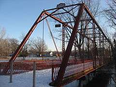
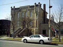
| 1 |
Chinworth Bridge |
|
000000001997-01-02-0000January 2, 1997
(#96001546) |
Junction of Old U.S. Route 30 and Road 350 W west of Warsaw, across the Tippecanoe River
41°14′49″N 85°54′38″W / 41.246944°N 85.910556°W / 41.246944; -85.910556 (Chinworth Bridge) |
Harrison and Wayne Townships |
|
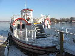
| 2 |
DIXIE (sternwheeler) |
|
000000002009-09-24-0000September 24, 2009
(#09000757) |
400 block of S. Dixie Dr.
41°19′22″N 85°41′36″W / 41.322778°N 85.693333°W / 41.322778; -85.693333 (DIXIE (sternwheeler)) |
North Webster |
|
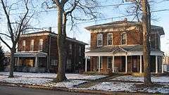
| 3 |
East Fort Wayne Street Historic District |
|
000000001993-05-27-0000May 27, 1993
(#93000472) |
503-613 E. Fort Wayne St.
41°14′25″N 85°51′01″W / 41.240278°N 85.850278°W / 41.240278; -85.850278 (East Fort Wayne Street Historic District) |
Warsaw |
|
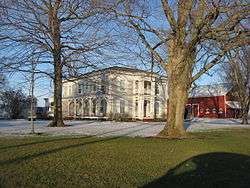
| 4 |
Hall Farm |
|
000000001992-09-16-0000September 16, 1992
(#92001164) |
Junction of 600N and 400W at Clunette
41°19′13″N 85°55′20″W / 41.320278°N 85.922222°W / 41.320278; -85.922222 (Hall Farm) |
Prairie Township |
|
| 5 |
Kosciusko County Jail |
|
000000001978-12-08-0000December 8, 1978
(#78000036) |
Main and Indiana Sts.
41°14′19″N 85°51′20″W / 41.238611°N 85.855556°W / 41.238611; -85.855556 (Kosciusko County Jail) |
Warsaw |
|
| 6 |
Leesburg Historic District |
|
000000001993-05-27-0000May 27, 1993
(#93000465) |
100 block of E. and W. Van Buren St.
41°19′54″N 85°51′00″W / 41.331667°N 85.85°W / 41.331667; -85.85 (Leesburg Historic District) |
Leesburg |
|
| 7 |
Mock School |
|
000000002010-12-27-0000December 27, 2010
(#10001081) |
Northwestern corner of the junction of N550E and E875N, south of Syracuse
41°21′40″N 85°44′25″W / 41.361000°N 85.740139°W / 41.361000; -85.740139 (Mock School) |
Turkey Creek Township |
|
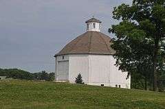
| 8 |
Robert Orr Polygonal Barn |
|
000000001993-04-02-0000April 2, 1993
(#93000190) |
State Road 13 south of North Webster, ½ mile north of its junction with Road 150 N
41°15′43″N 85°42′12″W / 41.261944°N 85.703333°W / 41.261944; -85.703333 (Robert Orr Polygonal Barn) |
Washington Township |
|
| 9 |
Pierceton Historic District |
|
000000001992-09-04-0000September 4, 1992
(#92001147) |
N. 1st St. from Catholic St. to the former Conrail railroad tracks
41°11′59″N 85°42′19″W / 41.199722°N 85.705278°W / 41.199722; -85.705278 (Pierceton Historic District) |
Pierceton |
|
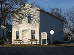
| 10 |
John Pound Store |
|
000000001992-06-17-0000June 17, 1992
(#92000672) |
Junction of Armstrong Rd. and 2nd St. at Oswego
41°19′13″N 85°47′14″W / 41.320278°N 85.787361°W / 41.320278; -85.787361 (John Pound Store) |
Plain Township |
|
| 11 |
Silver Lake Historic District |
|
000000001992-09-04-0000September 4, 1992
(#92001148) |
100 blocks of N. and S. Jefferson and E. and W. Main Sts.
41°04′19″N 85°53′32″W / 41.071944°N 85.892222°W / 41.071944; -85.892222 (Silver Lake Historic District) |
Silver Lake |
|
| 12 |
Warsaw Courthouse Square Historic District |
|
000000001982-03-01-0000March 1, 1982
(#82000046) |
Bounded by Center, N. Lake, Main, and Indiana Sts.; also roughly bounded by W. Main, W. Lake, Center, and S. Indiana Sts., and the alleys behind Indiana, Market, Lake, and Main Sts.
41°14′19″N 85°51′24″W / 41.238611°N 85.856667°W / 41.238611; -85.856667 (Warsaw Courthouse Square Historic District) |
Warsaw |
Second set of boundaries represents a boundary increase of 000000001993-09-21-0000September 21, 1993
|
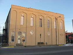
| 13 |
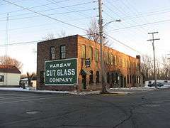
Warsaw Cut Glass Company |
|
000000001984-03-01-0000March 1, 1984
(#84001059) |
505 S. Detroit St.
41°14′01″N 85°51′10″W / 41.233611°N 85.852639°W / 41.233611; -85.852639 (Warsaw Cut Glass Company) |
Warsaw |
|
| 14 |
Winona Lake Historic District |
|
000000001993-12-10-0000December 10, 1993
(#93001411) |
Roughly bounded by Kings Highway, Chestnut Ave., 12th St., and Park Ave.
41°13′39″N 85°49′13″W / 41.2275°N 85.820278°W / 41.2275; -85.820278 (Winona Lake Historic District) |
Winona Lake |
|
| 15 |
Justin Zimmer House |
|
000000001991-12-19-0000December 19, 1991
(#91001865) |
2513 E. Center St.
41°14′18″N 85°49′18″W / 41.238333°N 85.821666°W / 41.238333; -85.821666 (Justin Zimmer House) |
Warsaw |
|
See also
References
- ↑ The latitude and longitude information provided in this table was derived originally from the National Register Information System, which has been found to be fairly accurate for about 99% of listings. For about 1% of NRIS original coordinates, experience has shown that one or both coordinates are typos or otherwise extremely far off; some corrections may have been made. A more subtle problem causes many locations to be off by up to 150 yards, depending on location in the country: most NRIS coordinates were derived from tracing out latitude and longitudes off of USGS topographical quadrant maps created under the North American Datum of 1927, which differs from the current, highly accurate WGS84 GPS system used by most on-line maps. Chicago is about right, but NRIS longitudes in Washington are higher by about 4.5 seconds, and are lower by about 2.0 seconds in Maine. Latitudes differ by about 1.0 second in Florida. Some locations in this table may have been corrected to current GPS standards.
- ↑ "National Register of Historic Places: Weekly List Actions". National Park Service, United States Department of the Interior. Retrieved on December 16, 2016.
- ↑ Numbers represent an ordering by significant words. Various colorings, defined here, differentiate National Historic Landmarks and historic districts from other NRHP buildings, structures, sites or objects.
- ↑ National Park Service (2009-03-13). "National Register Information System". National Register of Historic Places. National Park Service.
- ↑ The eight-digit number below each date is the number assigned to each location in the National Register Information System database, which can be viewed by clicking the number.
|
|---|
|
| Topics | |
|---|
|
| Lists by states | |
|---|
|
| Lists by insular areas | |
|---|
|
| Lists by associated states | |
|---|
|
| Other areas | |
|---|
|
-
 Portal Portal
-
 WikiProject WikiProject
|
|
|---|
|
| Topics | | |
|---|
|
Lists
by county | |
|---|
|
| Other lists | |
|---|
|
|