| [3] |
Name on the Register[4] |
Image |
Date listed[5] |
Location |
City or town |
Description |
|---|
| 1 |
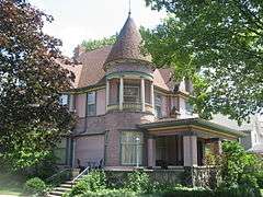
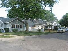
Beardsley Avenue Historic District |
|
000000002003-09-28-0000September 28, 2003
(#03000979) |
405 W. to 441 E. Beardsley Ave., the 700 block of N. Riverside, and Island Park
41°41′32″N 85°58′31″W / 41.692222°N 85.975278°W / 41.692222; -85.975278 (Beardsley Avenue Historic District) |
Elkhart |
|
| 2 |
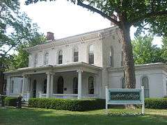
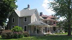
Albert R. Beardsley House |
|
000000001978-11-28-0000November 28, 1978
(#78000030) |
302 E. Beardsley Ave.
41°41′36″N 85°58′24″W / 41.693333°N 85.973333°W / 41.693333; -85.973333 (Albert R. Beardsley House) |
Elkhart |
|
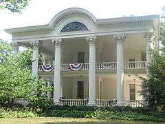
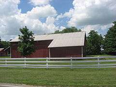
| 3 |
Dr. Havilah Beardsley House |
|
000000002000-06-22-0000June 22, 2000
(#00000716) |
102 W. Beardsley Ave.
41°41′36″N 85°58′36″W / 41.693333°N 85.976667°W / 41.693333; -85.976667 (Dr. Havilah Beardsley House) |
Elkhart |
|
| 4 |
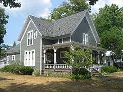
Emmanuel C. Bickel House |
|
000000001979-11-14-0000November 14, 1979
(#79000014) |
614 Bower St.
41°41′20″N 85°59′03″W / 41.688889°N 85.984167°W / 41.688889; -85.984167 (Emmanuel C. Bickel House) |
Elkhart |
|
| 5 |
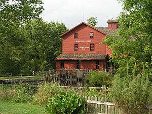
Bonneyville Mills |
|
000000001976-10-22-0000October 22, 1976
(#76000020) |
2.5 miles east of Bristol on County Road 131
41°43′10″N 85°45′53″W / 41.719444°N 85.764722°W / 41.719444; -85.764722 (Bonneyville Mills) |
York Township |
|
| 6 |
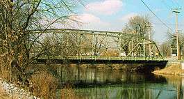
Bridge Street Bridge |
|
000000002009-09-24-0000September 24, 2009
(#09000755) |
Bridge St. over the St. Joseph River
41°40′37″N 85°59′27″W / 41.677°N 85.990717°W / 41.677; -85.990717 (Bridge Street Bridge) |
Elkhart |
|
| 7 |
Bristol-Washington Township School |
|
000000001991-08-29-0000August 29, 1991
(#91001164) |
304 W. Vistula St.
41°43′18″N 85°49′14″W / 41.721667°N 85.820556°W / 41.721667; -85.820556 (Bristol-Washington Township School) |
Bristol |
|
| 8 |
Charles Gerard Conn Mansion |
|
000000002007-12-19-0000December 19, 2007
(#07001278) |
723 Strong Ave.
41°41′07″N 85°59′11″W / 41.685278°N 85.986389°W / 41.685278; -85.986389 (Charles Gerard Conn Mansion) |
Elkhart |
|
| 9 |
Frank and Katharine Coppes House |
|
000000001990-11-29-0000November 29, 1990
(#90001783) |
302 E. Market St.
41°26′34″N 85°59′54″W / 41.442778°N 85.998472°W / 41.442778; -85.998472 (Frank and Katharine Coppes House) |
Nappanee |
|
| 10 |
Dierdorff Farmstead |
|
000000002011-03-21-0000March 21, 2011
(#11000122) |
2055 Dierdorff Rd., southeast of Goshen
41°33′36″N 85°48′18″W / 41.560000°N 85.805000°W / 41.560000; -85.805000 (Dierdorff Farmstead) |
Elkhart Township |
|
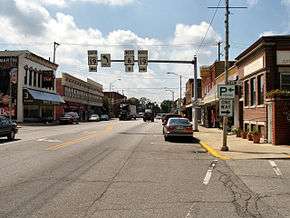
| 11 |
Downtown Nappanee Historic District |
|
000000001990-03-08-0000March 8, 1990
(#90000324) |
Main and Market Sts.
41°26′32″N 86°00′03″W / 41.442222°N 86.000833°W / 41.442222; -86.000833 (Downtown Nappanee Historic District) |
Nappanee |
|
| 12 |
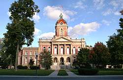
Elkhart County Courthouse |
|
000000001980-04-10-0000April 10, 1980
(#80000034) |
Courthouse Square
41°35′14″N 85°50′08″W / 41.587222°N 85.835556°W / 41.587222; -85.835556 (Elkhart County Courthouse) |
Goshen |
|
| 13 |
Elkhart Downtown Commercial Historic District |
|
000000001997-09-26-0000September 26, 1997
(#97001178) |
Roughly along Main St., roughly bounded by E. Jackson and 2nd Sts., Waterfall Dr., and Tyler Ave.
41°41′04″N 85°58′18″W / 41.684444°N 85.971667°W / 41.684444; -85.971667 (Elkhart Downtown Commercial Historic District) |
Elkhart |
|
| 14 |
Fort Wayne Street Bridge |
|
000000002005-09-15-0000September 15, 2005
(#05001018) |
Indiana Ave. over the Elkhart River
41°35′36″N 85°50′55″W / 41.593333°N 85.848611°W / 41.593333; -85.848611 (Fort Wayne Street Bridge) |
Goshen |
|
| 15 |
Solomon Fowler Mansion |
|
000000002003-09-28-0000September 28, 2003
(#03000974) |
11505 W. Vistula St.
41°43′07″N 85°49′47″W / 41.718611°N 85.829861°W / 41.718611; -85.829861 (Solomon Fowler Mansion) |
Bristol |
|
| 16 |
Goshen Carnegie Public Library |
|
000000001983-02-17-0000February 17, 1983
(#83000028) |
202 N. 5th St.
41°35′05″N 85°49′58″W / 41.584722°N 85.832778°W / 41.584722; -85.832778 (Goshen Carnegie Public Library) |
Goshen |
|
| 17 |
Goshen Historic District |
|
000000001983-02-17-0000February 17, 1983
(#83000029) |
Bounded by Pike, the railroad line, Cottage, Plymouth, Main, Purl, the Canal, and 2nd St.
41°34′57″N 85°49′57″W / 41.5825°N 85.8325°W / 41.5825; -85.8325 (Goshen Historic District) |
Goshen |
|
| 18 |
Green Block |
|
000000001980-07-17-0000July 17, 1980
(#80000035) |
109-115 E. Lexington
41°41′11″N 85°58′20″W / 41.686389°N 85.972222°W / 41.686389; -85.972222 (Green Block) |
Elkhart |
|
| 19 |
William and Helen Koerting House |
|
000000002009-12-22-0000December 22, 2009
(#09001128) |
2625 Greenleaf Boulevard
41°41′51″N 85°56′14″W / 41.697500°N 85.937222°W / 41.697500; -85.937222 (William and Helen Koerting House) |
Elkhart |
|
| 20 |
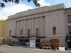
Lerner Theatre |
|
000000001980-10-02-0000October 2, 1980
(#80000036) |
401 S. Main St.
41°41′02″N 85°58′18″W / 41.683889°N 85.971667°W / 41.683889; -85.971667 (Lerner Theatre) |
Elkhart |
|
| 21 |
Arthur Miller House |
|
000000001992-04-02-0000April 2, 1992
(#92000184) |
253 E. Market St.
41°26′33″N 85°59′56″W / 41.442389°N 85.998889°W / 41.442389; -85.998889 (Arthur Miller House) |
Nappanee |
|
| 22 |
Mark L. and Harriet E. Monteith House |
|
000000001985-12-26-0000December 26, 1985
(#85003124) |
871 E. Beardsley Ave.
41°41′41″N 85°57′48″W / 41.694722°N 85.963333°W / 41.694722; -85.963333 (Mark L. and Harriet E. Monteith House) |
Elkhart |
|
| 23 |
Morehouse Residential Historic District |
|
000000002011-09-16-0000September 16, 2011
(#11000706) |
Roughly bounded by E. Indiana, Morehouse, E. Hubbard, and the western side of Frances Aves.
41°40′16″N 85°57′43″W / 41.671111°N 85.961944°W / 41.671111; -85.961944 (Morehouse Residential Historic District) |
Elkhart |
|
| 24 |
Nappanee Eastside Historic District |
|
000000002003-12-23-0000December 23, 2003
(#03001321) |
Roughly bounded by Market, Main, John, and Summit Sts.
41°26′39″N 85°59′52″W / 41.444167°N 85.997778°W / 41.444167; -85.997778 (Nappanee Eastside Historic District) |
Nappanee |
|
| 25 |
Nappanee West Park and Pavilion |
|
000000001994-03-28-0000March 28, 1994
(#94000231) |
Junction of Nappanee and Van Buren Sts.
41°26′48″N 86°00′19″W / 41.446667°N 86.005278°W / 41.446667; -86.005278 (Nappanee West Park and Pavilion) |
Nappanee |
|
| 26 |
Joseph and Sarah Puterbaugh Farm |
|
000000001995-03-03-0000March 3, 1995
(#95000198) |
59123 County Road 9, south of Elkhart
41°38′09″N 85°57′57″W / 41.635833°N 85.965833°W / 41.635833; -85.965833 (Joseph and Sarah Puterbaugh Farm) |
Concord Township |
|
| 27 |
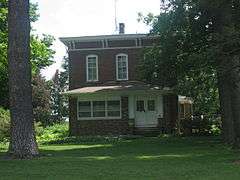
Joseph J. Rohrer Farm |
|
000000001990-02-23-0000February 23, 1990
(#90000330) |
24394 County Road 40, southwest of Goshen
41°32′08″N 85°55′56″W / 41.535556°N 85.932222°W / 41.535556; -85.932222 (Joseph J. Rohrer Farm) |
Harrison Township |
|
| 28 |
St. John of the Cross Episcopal Church, Rectory and Cemetery |
|
000000001980-09-17-0000September 17, 1980
(#80000037) |
601 and 611 E. Vistula Rd.
41°43′16″N 85°48′40″W / 41.721111°N 85.811111°W / 41.721111; -85.811111 (St. John of the Cross Episcopal Church, Rectory and Cemetery) |
Bristol |
|
| 29 |
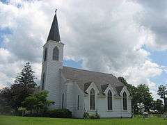
St. John's Lutheran Church |
|
000000001994-11-25-0000November 25, 1994
(#94001349) |
Northeastern corner of the junction of County Roads 15 and 32, west of Goshen
41°34′50″N 85°54′21″W / 41.580417°N 85.905972°W / 41.580417; -85.905972 (St. John's Lutheran Church) |
Harrison Township |
|
| 30 |
Stahly-Nissley-Kuhns Farm |
|
000000001990-11-29-0000November 29, 1990
(#90001793) |
1600 W. Market St.
41°26′39″N 86°01′02″W / 41.444167°N 86.017222°W / 41.444167; -86.017222 (Stahly-Nissley-Kuhns Farm) |
Nappanee |
|
| 31 |
State Street-Division Street Historic District |
|
000000001999-02-26-0000February 26, 1999
(#99000255) |
Roughly both sides of State and Division Sts. between Main and Monroe
41°40′58″N 85°57′59″W / 41.682778°N 85.966389°W / 41.682778; -85.966389 (State Street-Division Street Historic District) |
Elkhart |
|
| 32 |
William N. Violett House |
|
000000001984-09-20-0000September 20, 1984
(#84001026) |
3004 S. Main St.
41°32′40″N 85°49′40″W / 41.544583°N 85.827778°W / 41.544583; -85.827778 (William N. Violett House) |
Goshen |
|
| 33 |
Violett-Martin House and Gardens |
|
000000002007-09-20-0000September 20, 2007
(#07000978) |
2612 S. Main St.
41°33′02″N 85°49′40″W / 41.550500°N 85.827778°W / 41.550500; -85.827778 (Violett-Martin House and Gardens) |
Goshen |
|
| 34 |
Young Women's Christian Association |
|
000000001991-03-21-0000March 21, 1991
(#91000257) |
120 W. Lexington Ave.
41°41′11″N 85°58′26″W / 41.686389°N 85.973889°W / 41.686389; -85.973889 (Young Women's Christian Association) |
Elkhart |
|