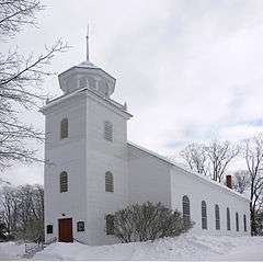
| [3] |
Name on the Register[4] |
Image |
Date listed[5] |
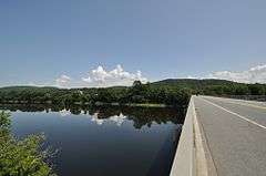
Location |
City or town |
Description |
|---|
| 1 |
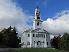
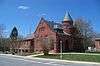
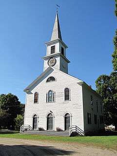
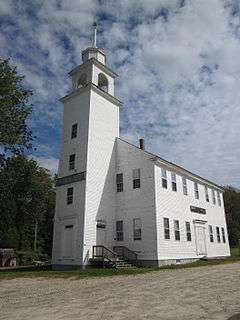
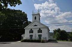
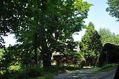
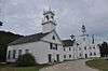
Acworth Congregational Church |
|
000000001975-06-13-0000June 13, 1975
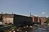
(#75000132) |
Northern end of town common
43°13′08″N 72°17′38″W / 43.218889°N 72.293889°W / 43.218889; -72.293889 (Acworth Congregational Church) |
Acworth |
|
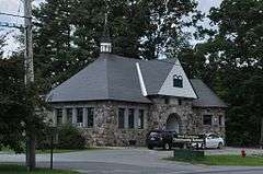
| 2 |
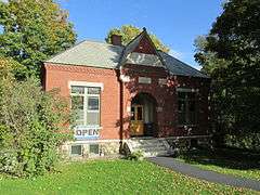
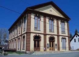
Acworth Silsby Library |
|
000000001983-12-08-0000December 8, 1983
(#83004206) |
Intersection of Cold Pond and Lynn Hill Rds.
43°13′06″N 72°17′33″W / 43.218333°N 72.2925°W / 43.218333; -72.2925 (Acworth Silsby Library) |
Acworth |
|
| 3 |
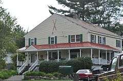
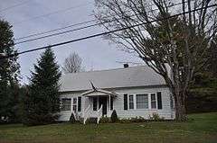
Backside Inn |
|
000000001985-06-21-0000June 21, 1985
(#85001308) |
Brook Rd.
43°18′47″N 72°06′51″W / 43.3131°N 72.1142°W / 43.3131; -72.1142 (Backside Inn) |
Goshen |
|
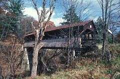
| 4 |
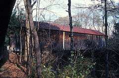
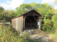
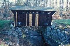
Blow-Me-Down Covered Bridge |
|
000000001978-05-19-0000May 19, 1978
(#78000220) |
South of Plainfield off NH 12A
43°31′02″N 72°22′28″W / 43.517222°N 72.374444°W / 43.517222; -72.374444 (Blow-Me-Down Covered Bridge) |
Plainfield |
Over Blow-me-down Brook
|
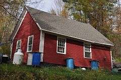
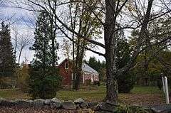
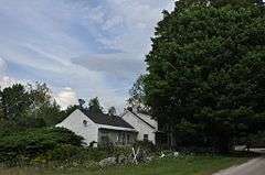
| 5 |
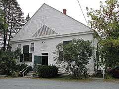
Blow-Me-Down Grange |
|
000000002001-03-02-0000March 2, 2001
(#01000205) |
1071 NH 12A
43°32′01″N 72°21′24″W / 43.533611°N 72.356667°W / 43.533611; -72.356667 (Blow-Me-Down Grange) |
Plainfield |
|
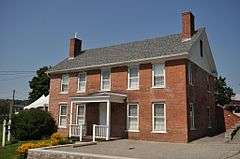
| 6 |
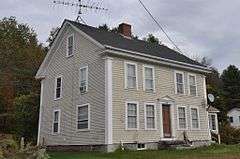
Burford House |
|
000000001985-06-21-0000June 21, 1985
(#85001309) |
NH 10
43°17′59″N 72°08′55″W / 43.2997°N 72.1486°W / 43.2997; -72.1486 (Burford House) |
Goshen |
|
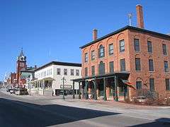
| 7 |
Central Business District |
|
000000001978-02-21-0000February 21, 1978
(#78003454) |
Roughly bounded by Crescent, Broad, Pine, and Franklin Sts.
43°22′17″N 72°20′14″W / 43.371389°N 72.337222°W / 43.371389; -72.337222 (Central Business District) |
Claremont |
|
| 8 |
Charlestown Main Street Historic District |
|
000000001987-06-10-0000June 10, 1987
(#87000835) |
Main St.
43°14′06″N 72°25′26″W / 43.235°N 72.423889°W / 43.235; -72.423889 (Charlestown Main Street Historic District) |
Charlestown |
|
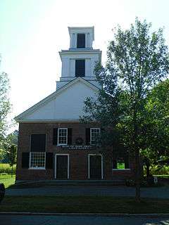
| 9 |
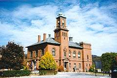
Charlestown Town Hall |
|
000000001984-03-15-0000March 15, 1984
(#84003252) |
North of Summer St., off Main St.
43°14′09″N 72°25′26″W / 43.235833°N 72.423889°W / 43.235833; -72.423889 (Charlestown Town Hall) |
Charlestown |
|
| 10 |
Salmon P. Chase Birthplace |
|
000000001975-05-15-0000May 15, 1975
(#75000133) |
8 mi (13 km) north of Claremont
43°27′18″N 72°23′14″W / 43.455°N 72.387222°W / 43.455; -72.387222 (Salmon P. Chase Birthplace) |
Cornish |
Birthplace and childhood home of Salmon P. Chase
|
| 11 |
Claremont City Hall |
|
000000001973-04-26-0000April 26, 1973
(#73000176) |
Tremont Sq.
43°22′21″N 72°20′15″W / 43.3725°N 72.3375°W / 43.3725; -72.3375 (Claremont City Hall) |
Claremont |
|
| 12 |
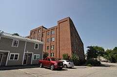
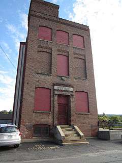
Claremont Warehouse No. 34 |
|
000000001979-02-28-0000February 28, 1979
(#79000320) |
43 River St.
43°22′32″N 72°20′42″W / 43.375556°N 72.345°W / 43.375556; -72.345 (Claremont Warehouse No. 34) |
Claremont |
|
| 13 |
Cold River Bridge |
|
000000001973-05-17-0000May 17, 1973
(#73000177) |
East of Langdon on McDermott Rd
43°10′13″N 72°20′46″W / 43.170278°N 72.346111°W / 43.170278; -72.346111 (Cold River Bridge) |
Langdon |
Over Cold River
|
| 14 |
Cornish–Windsor Covered Bridge |
|
000000001976-11-21-0000November 21, 1976
(#76000135) |
West of Cornish City
43°28′26″N 72°23′01″W / 43.473889°N 72.383611°W / 43.473889; -72.383611 (Cornish–Windsor Covered Bridge) |
Cornish |
Over Connecticut River, connecting to Windsor, Vermont
|
| 15 |
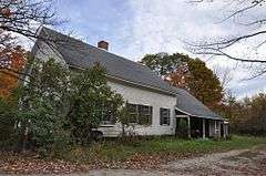
Cote House |
|
000000001985-06-21-0000June 21, 1985
(#85001310) |
Goshen Center Rd.
43°17′44″N 72°07′03″W / 43.295556°N 72.1175°W / 43.295556; -72.1175 (Cote House) |
Goshen |
|
| 16 |
Covit House |
|
000000001985-06-21-0000June 21, 1985
(#85001311) |
Goshen Center Rd.
43°17′44″N 72°06′54″W / 43.295527°N 72.115058°W / 43.295527; -72.115058 (Covit House) |
Goshen |
|
| 17 |
David Dexter House |
|
000000001979-11-29-0000November 29, 1979
(#79000213) |
Dexter Heights
43°22′37″N 72°20′16″W / 43.376944°N 72.337778°W / 43.376944; -72.337778 (David Dexter House) |
Claremont |
|
| 18 |
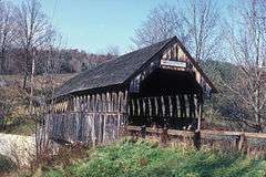
Dingleton Hill Covered Bridge |
|
000000001978-11-08-0000November 8, 1978
(#78000221) |
Off NH 12A
43°27′51″N 72°22′09″W / 43.464167°N 72.369167°W / 43.464167; -72.369167 (Dingleton Hill Covered Bridge) |
Cornish Mills |
Over Mill Brook
|
| 19 |
Durham House |
|
000000001985-06-21-0000June 21, 1985
(#85001312) |
Ball Park Rd.
43°16′32″N 72°08′03″W / 43.2756°N 72.1342°W / 43.2756; -72.1342 (Durham House) |
Goshen |
|
| 20 |
English Church |
|
000000001980-02-01-0000February 1, 1980
(#80000318) |
Old Church Rd.
43°22′59″N 72°22′18″W / 43.383056°N 72.371667°W / 43.383056; -72.371667 (English Church) |
Claremont |
|
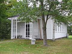
| 21 |
Farwell School |
|
000000001990-12-06-0000December 6, 1990
(#90001847) |
NH 12A south of Hope Hill Cemetery
43°18′34″N 72°23′19″W / 43.309444°N 72.388611°W / 43.309444; -72.388611 (Farwell School) |
Charlestown |
|
| 22 |
First Baptist Church of Cornish |
|
000000001978-02-14-0000February 14, 1978
(#78000222) |
Meriden Stage Rd. and NH 120
43°29′54″N 72°16′48″W / 43.498333°N 72.28°W / 43.498333; -72.28 (First Baptist Church of Cornish) |
Cornish Flat |
|
| 23 |
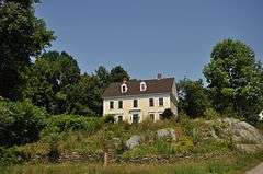
First Universalist Chapel |
|
000000002006-12-12-0000December 12, 2006
(#06001130) |
3 2nd New Hampshire Turnpike
43°13′39″N 72°10′43″W / 43.2275°N 72.178611°W / 43.2275; -72.178611 (First Universalist Chapel) |
Lempster |
This 1845 building is now the town library.
|
| 24 |
Garber House |
|
000000001985-06-21-0000June 21, 1985
(#85001313) |
Willey Hill Rd.
43°16′43″N 72°07′56″W / 43.278611°N 72.132222°W / 43.278611; -72.132222 (Garber House) |
Goshen |
|
| 25 |
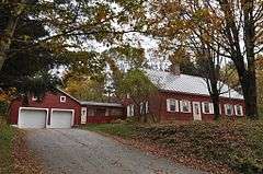
Giffin House |
|
000000001985-06-21-0000June 21, 1985
(#85001314) |
NH 10
43°17′56″N 72°08′53″W / 43.2989°N 72.1481°W / 43.2989; -72.1481 (Giffin House) |
Goshen |
|
| 26 |
Capt. John Gunnison House |
|
000000001979-12-19-0000December 19, 1979
(#79000214) |
East of Goshen on Goshen Center Rd.
43°17′37″N 72°07′38″W / 43.293628°N 72.127095°W / 43.293628; -72.127095 (Capt. John Gunnison House) |
Goshen |
|
| 27 |
Hunter Archeological Site |
|
000000001976-06-07-0000June 7, 1976
(#76000222) |
Near the bridge to Ascutney, Vermont[6]
43°24′11″N 72°24′02″W / 43.4031°N 72.4005°W / 43.4031; -72.4005 (Hunter Archeological Site) |
Claremont |
Native American archeological site; location of at least three longhouses[6]
|
| 28 |
Janicke House |
|
000000001985-06-21-0000June 21, 1985
(#85001315) |
Goshen Center Rd.
43°17′47″N 72°06′55″W / 43.296389°N 72.115278°W / 43.296389; -72.115278 (Janicke House) |
Goshen |
|
| 29 |
Kenyon Bridge |
|
000000001978-05-22-0000May 22, 1978
(#78000223) |
Off NH 12A at Mill Brook and Town House Rd.
43°28′00″N 72°21′03″W / 43.466667°N 72.350833°W / 43.466667; -72.350833 (Kenyon Bridge) |
Cornish City |
|
| 30 |
Knights-Morey House |
|
000000001985-06-21-0000June 21, 1985
(#85001316) |
Province Rd.
43°19′23″N 72°07′19″W / 43.323113°N 72.121988°W / 43.323113; -72.121988 (Knights-Morey House) |
Goshen |
|
| 31 |
Lear House |
|
000000001985-06-21-0000June 21, 1985
(#85001317) |
Province Rd.
43°19′47″N 72°06′21″W / 43.329638°N 72.105788°W / 43.329638; -72.105788 (Lear House) |
Goshen |
|
| 32 |
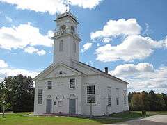
Lempster Meetinghouse |
|
000000001980-09-08-0000September 8, 1980
(#80000319) |
Lempster St.
43°14′20″N 72°12′38″W / 43.238889°N 72.210556°W / 43.238889; -72.210556 (Lempster Meetinghouse) |
Lempster |
|
| 33 |
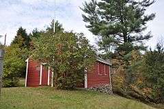
Little Red School House 1835 District No. 7 |
|
000000001980-12-01-0000December 1, 1980
(#80000320) |
South of Newport on NH 10
43°20′08″N 72°10′06″W / 43.335556°N 72.168333°W / 43.335556; -72.168333 (Little Red School House 1835 District No. 7) |
Newport |
|
| 34 |
Lower Village District |
|
000000001978-02-21-0000February 21, 1978
(#78003455) |
Along Central St. and Main St. on both sides of the Sugar River
43°22′29″N 72°20′34″W / 43.374722°N 72.342778°W / 43.374722; -72.342778 (Lower Village District) |
Claremont |
|
| 35 |
Meriden Bridge |
|
000000001980-08-27-0000August 27, 1980
(#80000321) |
Northwest of Meriden
43°33′12″N 72°16′00″W / 43.553333°N 72.266667°W / 43.553333; -72.266667 (Meriden Bridge) |
Meriden |
Over Bloods Brook
|
| 36 |
Meriden Town Hall |
|
000000001998-12-20-0000December 20, 1998
(#98001548) |
110 Main St.
43°32′54″N 72°15′39″W / 43.54833°N 72.260903°W / 43.54833; -72.260903 (Meriden Town Hall) |
Plainfield |
A second town hall, in Plainfield's Meriden section
|
| 37 |
Monadnock Mills |
|
000000001979-02-15-0000February 15, 1979
(#79000272) |
Broad, Water, Crescent Sts., and Mill Rd.
43°22′26″N 72°20′17″W / 43.3738°N 72.3380°W / 43.3738; -72.3380 (Monadnock Mills) |
Claremont |
|
| 38 |
Mothers' and Daughters' Club House |
|
000000001982-03-11-0000March 11, 1982
(#82001697) |
Main St.
43°32′10″N 72°21′19″W / 43.536111°N 72.355278°W / 43.536111; -72.355278 (Mothers' and Daughters' Club House) |
Plainfield |
|
| 39 |
Nettleton House |
|
000000001977-11-16-0000November 16, 1977
(#77000164) |
26-30 Central St.
43°21′52″N 72°10′18″W / 43.364502°N 72.171627°W / 43.364502; -72.171627 (Nettleton House) |
Newport |
|
| 40 |
Newport Downtown Historic District |
|
000000001985-06-06-0000June 6, 1985
(#85001201) |
Main St. roughly bounded by Depot, Sunapee, Central and West Sts.
43°21′48″N 72°10′20″W / 43.363333°N 72.172222°W / 43.363333; -72.172222 (Newport Downtown Historic District) |
Newport |
|
| 41 |
North Charlestown Historic District |
|
000000002005-06-09-0000June 9, 2005
(#05000568) |
River Rd.
43°18′33″N 72°23′18″W / 43.309167°N 72.388333°W / 43.309167; -72.388333 (North Charlestown Historic District) |
Charlestown |
|
| 42 |
Pier Bridge |
|
000000001975-06-10-0000June 10, 1975
(#75000134) |
3 mi (4.8 km) west of Newport on Chandler Rd. over the Sugar River
43°21′43″N 72°14′31″W / 43.361944°N 72.241944°W / 43.361944; -72.241944 (Pier Bridge) |
Newport |
|
| 43 |
Pike House |
|
000000001985-06-21-0000June 21, 1985
(#85001318) |
NH 10
43°18′02″N 72°08′52″W / 43.300665°N 72.147776°W / 43.300665; -72.147776 (Pike House) |
Goshen |
|
| 44 |
Plainfield Town Hall |
|
000000001985-06-06-0000June 6, 1985
(#85001200) |
NH 12A
43°32′08″N 72°21′17″W / 43.535556°N 72.354722°W / 43.535556; -72.354722 (Plainfield Town Hall) |
Plainfield |
|
| 45 |
Prentiss Bridge |
|
000000001973-05-24-0000May 24, 1973
(#73000179) |
South of Langdon off Old Cheshire Turnpike
43°09′11″N 72°23′38″W / 43.153056°N 72.393889°W / 43.153056; -72.393889 (Prentiss Bridge) |
Langdon |
Over Great Brook
|
| 46 |
Protectworth Tavern |
|
000000001980-11-25-0000November 25, 1980
(#80000322) |
NH 4A
43°30′37″N 72°02′03″W / 43.510278°N 72.034167°W / 43.510278; -72.034167 (Protectworth Tavern) |
Springfield |
|
| 47 |
Purnell House |
|
000000001985-06-21-0000June 21, 1985
(#85001319) |
NH 10
43°18′18″N 72°09′19″W / 43.305006°N 72.15519°W / 43.305006; -72.15519 (Purnell House) |
Goshen |
|
| 48 |
Isaac Reed House |
|
000000001978-07-19-0000July 19, 1978
(#78000337) |
30-34 Main St.
43°21′51″N 72°10′21″W / 43.364167°N 72.1725°W / 43.364167; -72.1725 (Isaac Reed House) |
Newport |
|
| 49 |
Richards Free Library |
|
000000001984-09-07-0000September 7, 1984
(#84003257) |
58 N. Main St.
43°22′00″N 72°10′34″W / 43.366667°N 72.176111°W / 43.366667; -72.176111 (Richards Free Library) |
Newport |
|
| 50 |
William Rossiter House |
|
000000001979-05-25-0000May 25, 1979
(#79000215) |
11 Mulberry St.
43°22′20″N 72°20′41″W / 43.372222°N 72.344722°W / 43.372222; -72.344722 (William Rossiter House) |
Claremont |
|
| 51 |
Saint-Gaudens National Historic Site |
|
000000001966-10-15-0000October 15, 1966
(#66000120) |
South of Plainfield off NH 12A
43°30′02″N 72°22′08″W / 43.500556°N 72.368889°W / 43.500556; -72.368889 (Saint-Gaudens National Historic Site) |
Cornish |
Home and studio of American sculptor Augustus Saint-Gaudens; a National Historic Landmark and National Historic Site; expanded listing in 2013
|
| 52 |
Scranton House |
|
000000001985-06-21-0000June 21, 1985
(#85001320) |
711 Brook Rd.
43°18′42″N 72°07′49″W / 43.3117°N 72.1303°W / 43.3117; -72.1303 (Scranton House) |
Goshen |
|
| 53 |
Seavey House |
|
000000001985-06-21-0000June 21, 1985
(#85001321) |
NH 10
43°17′53″N 72°08′50″W / 43.2981°N 72.1472°W / 43.2981; -72.1472 (Seavey House) |
Goshen |
|
| 54 |
South Congregational Church |
|
000000001989-03-30-0000March 30, 1989
(#89000187) |
58 S. Main St.
43°21′40″N 72°10′14″W / 43.361111°N 72.170556°W / 43.361111; -72.170556 (South Congregational Church) |
Newport |
|
| 55 |
Springfield Town Hall and Howard Memorial Methodist Church |
|
000000001986-06-05-0000June 5, 1986
(#86001235) |
Four Corners Rd. southeast of New London Rd.
43°29′43″N 72°02′55″W / 43.4953°N 72.0486°W / 43.4953; -72.0486 (Springfield Town Hall and Howard Memorial Methodist Church) |
Springfield |
|
| 56 |
Louis St. Gaudens House and Studio |
|
000000001972-11-15-0000November 15, 1972
(#72000111) |
Dingleton Hill and Whitten Rds.
43°30′01″N 72°20′51″W / 43.500278°N 72.3475°W / 43.500278; -72.3475 (Louis St. Gaudens House and Studio) |
Cornish |
|
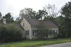
| 57 |
Stelljes House |
Upload image |
000000001985-06-21-0000June 21, 1985
(#85001322) |
NH 31
43°15′37″N 72°06′58″W / 43.260278°N 72.116111°W / 43.260278; -72.116111 (Stelljes House) |
Goshen |
Possibly demolished
|
| 58 |
Sullivan County Courthouse |
|
000000001973-06-25-0000June 25, 1973
(#73000178) |
Court Sq.
43°21′52″N 72°10′19″W / 43.364482°N 72.172044°W / 43.364482; -72.172044 (Sullivan County Courthouse) |
Newport |
Former (1824) courthouse, on hill behind town hall/current court
|
| 59 |
Town Hall and Courthouse |
|
000000001980-02-29-0000February 29, 1980
(#80000383) |
20 Main St.
43°21′53″N 72°10′21″W / 43.3646°N 72.1726°W / 43.3646; -72.1726 (Town Hall and Courthouse) |
Newport |
Now the Opera House
|
| 60 |
Trinity Church |
|
000000001978-07-31-0000July 31, 1978
(#78000419) |
West of Cornish Mills on NH 12A
43°28′01″N 72°23′06″W / 43.466944°N 72.385°W / 43.466944; -72.385 (Trinity Church) |
Cornish Mills |
|
| 61 |
Unity Town Hall |
|
000000001985-06-06-0000June 6, 1985
(#85001199) |
Off Unity Rd. and the Old New Hampshire Turnpike
43°18′12″N 72°15′42″W / 43.303333°N 72.261667°W / 43.303333; -72.261667 (Unity Town Hall) |
Unity |
|
| 62 |
Washington Common Historic District |
|
000000001986-03-14-0000March 14, 1986
(#86000345) |
Junction of Half Moon Pond and Millen Pond Rds.
43°10′34″N 72°05′47″W / 43.1761°N 72.0964°W / 43.1761; -72.0964 (Washington Common Historic District) |
Washington |
|
| 63 |
Welcome Acres |
|
000000001985-06-21-0000June 21, 1985
(#85001323) |
NH 10
43°18′16″N 72°09′12″W / 43.30444°N 72.153338°W / 43.30444; -72.153338 (Welcome Acres) |
Goshen |
|
| 64 |
Williamson House |
|
000000001985-06-21-0000June 21, 1985
(#85001324) |
Messer Rd.
43°20′02″N 72°06′47″W / 43.333778°N 72.113105°W / 43.333778; -72.113105 (Williamson House) |
Goshen |
|
| 65 |
Windswept Acres-Powers House |
|
000000001985-06-21-0000June 21, 1985
(#85001325) |
NH 31
43°15′38″N 72°07′11″W / 43.260626°N 72.119843°W / 43.260626; -72.119843 (Windswept Acres-Powers House) |
Goshen |
|
| 66 |
Wright's Bridge |
|
000000001975-06-10-0000June 10, 1975
(#75000135) |
East of Claremont off Chandler Rd. on the Sugar River Trail over the Sugar River
43°21′33″N 72°15′34″W / 43.359167°N 72.259444°W / 43.359167; -72.259444 (Wright's Bridge) |
Newport |
|


.jpg)


.jpg)

