Japan National Route 4
| |
|---|---|
| Kokudō Yongō (国道4号) | |
 | |
| Route information | |
| Length: | 743.6 km (462.1 mi) |
| Major junctions | |
| South end: |
|
| North end: |
|
| Highway system | |
|
National highways of Japan Expressways of Japan | |

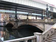
Nihonbashi in Tokyo
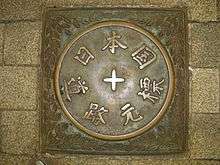
0 km post of Japanese Roads in Tokyo
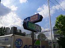
Intersection with Meiji-dōri Avenue
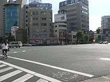
Minowa Intersection
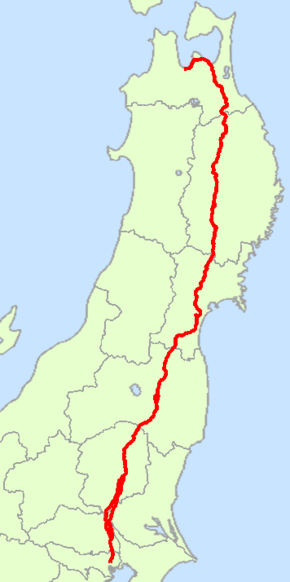
National Route 4 (国道4号 Kokudō Yongō) is a major highway in eastern Honshu, Japan. It is the longest highway in Japan at 743.6 km (462.1 mi), and it connects Tokyo and Aomori via Utsunomiya, Kōriyama and Morioka.
From Saitama Prefecture to Iwate Prefecture, it parallels the Tōhoku Expressway; from Morioka to Hachinohe, it parallels the Hachinohe Expressway. At its northern end point, it links with Route 7.[1]
Route data
- Total length: 743.6 km (462.1 mi)
- Origin point: Chūō, Tokyo (originates at Nihonbashi, the origins also of Routes 1, 6, 14, 15, 17 and 20)
- End point: Aomori (ends at the end point also of National Route 7)
- Major cities on its route: Kasukabe, Koga, Utsunomiya, Kōriyama, Fukushima (Nakadōri), Sendai, Furukawa, Hiraizumi, Morioka, Ninohe, Towada and Noheji
Municipalities it passes through
- Tokyo
- Saitama Prefecture
- Ibaraki Prefecture
- Tochigi Prefecture
- Nogi - Oyama - Shimotsuke - Kaminokawa, Shimotsuke, Utsunomiya - Takanezawa - Sakura - Yaita - Otawara - Nasushiobara - Nasu
- Fukushima Prefecture
- Miyagi Prefecture
- Shiroishi - Zaō - Ōgawara - Murata - Shibata - Iwanuma - Natori - Taihaku-ku, Sendai - Wakabayashi-ku, Sendai - Miyagino-ku, Sendai - Izumi-ku, Sendai - Tomiya - Taiwa - Shiroishi - Ōhira - Ōsaki - Kurihara
- Iwate Prefecture
- Aomori Prefecture
History
4 December 1952: First Class National Highway 4 (from Tokyo to Aomori)
1 April 1965: General National Highway 4 (from Tokyo to Aomori)
Intersecting routes
- in Tokyo
- in Saitama Prefecture
- National Route 298 at Sōka
- National Route 463 at Koshigaya
- National Route 16 at Kasukabe
- National Route 125 at Kuki
- in Ibaraki Prefecture
- in Tochigi Prefecture
- National Route 50 at Oyama
- National Route 352 at Shimotsuke
- Routes 119, 121 and 123 at Utsunomiya
- National Route 408 at Takanezawa
- National Route 293 at Sakura
- National Route 461 at Yaita
- Route 461 at Ōtawara
- National Route 400 at Nasushiobara
- in Fukushima Prefecture
- Routes 289 and 294 at Shirakawa
- National Route 118 at Sukagawa
- Routes 49 and 288 at Kōriyama
- National Route 459 at Nihonmatsu
- Routes 13, 114 and 115 at Fukushima
- National Route 399 at Date
- in Miyagi Prefecture
- Routes 113 and 457 at Shiroishi
- National Route 349 at Shibata
- Route 6 at Iwanuma
- National Route 286 at Taihaku-ku, Sendai
- Routes 45 and 48 at Miyagino-ku, Sendai
- Routes 47, 108 and 347 at Ōsaki
- National Route 398 at Kurihara
- in Iwate Prefecture
- Routes 284, 342 and 457 at Ichinoseki
- Routes 343 and 397 at Ōshū
- National Route 107 at Kitakami
- National Route 283 at Hanamaki
- Routes 46, 106, 396 and 455 at Morioka
- National Route 282 at Takizawa
- National Route 281 at Iwate
- in Aomori Prefecture
- National Route 104 at Sannohe
- Route 104 at Nanbu
- National Route 454 at Gonohe
- Routes 45 and 102 at Towada
- National Route 394 at Shichinohe
- National Route 279 at Noheji
- Routes 7, 103 and 280 at the end point
References
External links
| Wikimedia Commons has media related to Route 4 (Japan). |
This article is issued from Wikipedia - version of the 7/5/2016. The text is available under the Creative Commons Attribution/Share Alike but additional terms may apply for the media files.