Poonch district, India
| Poonch district, India | |
|---|---|
| District | |
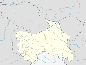 Poonch district, India  Poonch district, India Location in Jammu and Kashmir, India | |
| Coordinates: 33°46′N 74°06′E / 33.77°N 74.1°ECoordinates: 33°46′N 74°06′E / 33.77°N 74.1°E | |
| Country |
|
| State | Jammu and Kashmir |
| Headquarters | Poonch |
| Languages | |
| • Official | Urdu |
| Time zone | IST (UTC+5:30) |
| PIN | 185101 |
| Telephone code | 911965 |
| Vehicle registration | JK |
| Website |
www |
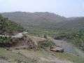
District Poonch or Punch is one of the most remote districts of Jammu and Kashmir. It is bounded by the Line of Control (boundary between Indian and Pakistan-administered Kashmir) on three sides (north, west and south). The 1947-48 war between India and Pakistan divided it into two parts. One went to Pakistan and the other became part of the Indian state of Jammu & Kashmir.
Administration
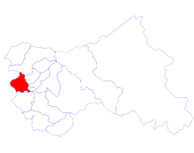
The District headquarters is in the Poonch city. Mohammad Harun Malik is the current District Commissioner. Presently District Poonch in Jammu and Kashmir is divided into eight tehsils:
- Haveli Tehsil
- Mandi Tehsil
- Mendhar Tehsil
- Surankote Tehsil
- Chandak Tehsil
- Mankote Tehsil
- Balakote Tehsil
- Bufliaz Tehsil
Each tehsil has its Tehsildar, who is the administrative head. The district is further divided into six blocks: Poonch, Mandi, Mendhar, Balakote, Surankote and Buffliaz.[1] The administrative head of each block is the Block Development Officer (BDO). Each block consists of a number of panchayats. Recently added One Sub Division(Surnkote), other is Mendhar. Poonch district has a total of 179 villages including Seri Khawaja.
Economy
In 2006 the Ministry of Panchayati Raj named Poonch one of the country's 250 most backward districts (out of a total of 640).[2] It is one of the three districts in Jammu and Kashmir currently receiving funds from the Backward Regions Grant Fund Programme (BRGF).[2]
Politics
Poonch District has 3 assembly constituencies: Surankote, Mendhar and Poonch Haveli. The present M.L.A of Poonch Haveli is Shah Mohammed Tantray of Jammu & Kashmir Peoples Democratic Party, Mohammed Akram of Indian National Congress is currently representing Surankote constituency and Mendhar is being represented by Javid Rana of Jammu & Kashmir National Conference. Poonch district comes in Jammu-Poonch Lok Sabha Constituency.[3]
Demographics
According to the 2011 census Poonch district, India has a population of 476,820,[4] roughly equal to the nation of Suriname.[5] This gives it a ranking of 548th in India (out of a total of 640).[4] The district has a population density of 285 inhabitants per square kilometre (740/sq mi).[4] Its population growth rate over the decade 2001-2011 was 27.97%.[4] Poonch has a sex ratio of 890 females for every 1000 males,[4] and a literacy rate of 68.69%.[4] The district is 90.45% Muslim.[6]
Resident ethnicities include Gujjars, Bakerwals, Paharis, Punjabis, Kashmiris and Rajputs. Gujjars mostly reside on the slopes of mountains. They have small pieces of land for cultivation, and cattle for supplementing their economy. Bakerwals are nomadic tribes. Gujjars and Bakerwals speak Gojri whereas rest of the population (excluding Kashmiris) speak Pahari/Poonchi. The mother tongue is a great cementing factor of the Pahari speaking people because they remain closely associated with each other despite differing faiths.[7]
Peace
With the recent developments between India and Pakistan, the divided people are again coming into contact with each other. The opening of the Poonch-Rawalakot bus is an important step in this direction.
Transport
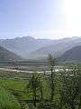
Air There is a small airstrip located which is mainly used by Indian Army. Rail There is no railway connectivity to Poonch yet. Road Poonch district is connected to the summer capital jammuby an all-weather road. It also has road connectivity with Srinagar through the pictureresque Mughal Road. A bus across the LOC, the Poonch-Rawalakot bus has helped to re-establish ties across the border.
Gallery


See also
References
- ↑ Statement showing the number of blocks in respect of 22 Districts of Jammu and Kashmir State including newly Created Districts dated 2008-03-13, accessed 2008-08-30
- 1 2 Ministry of Panchayati Raj (September 8, 2009). "A Note on the Backward Regions Grant Fund Programme" (PDF). National Institute of Rural Development. Retrieved September 27, 2011.
- ↑ "ERO's and AERO's". Chief Electoral Officer, Jammu and Kashmir. Retrieved 2008-08-28.
- 1 2 3 4 5 6 "District Census 2011". Census2011.co.in. 2011. Retrieved 2011-09-30.
- ↑ US Directorate of Intelligence. "Country Comparison:Population". Retrieved 2011-10-01.
Suriname 491,989 July 2011 est.
- ↑ http://www.census2011.co.in
- ↑ About Poonch – Official site of District Poonch of J&K
External links
- Official website of District Poonch – Administered by India.
- The entire list of rulers starting from Raja Moti Singh
- List of places in Poonch
 |
Baramula district | Badgam district | | |
| Disputed region | |
|||
| ||||
| | ||||
| Rajouri district | Kulgam district |