Prairie County, Arkansas
| Prairie County, Arkansas | |
|---|---|
| County | |
| County of Prairie | |
 Prairie County Courthouse, De Valls Bluff | |
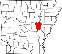 Location in the U.S. state of Arkansas | |
 Arkansas's location in the U.S. | |
| Founded | October 25, 1846 |
| Seat | Des Arc, De Valls Bluff |
| Largest city | Des Arc |
| Area | |
| • Total | 676 sq mi (1,751 km2) |
| • Land | 648 sq mi (1,678 km2) |
| • Water | 28 sq mi (73 km2), 4.1% |
| Population (est.) | |
| • (2015) | 8,291 |
| • Density | 13/sq mi (5/km²) |
| Congressional district | 1st |
| Time zone | Central: UTC-6/-5 |
Prairie County is a county located in the U.S. state of Arkansas. As of the 2010 census, the population was 8,715.[1] The county has two county seats, Des Arc and De Valls Bluff.[2] Prairie County was formed on October 25, 1846, and named for the Grand Prairie of eastern Arkansas.
History
The county was at first land given to Cherokee Indian settlers from Tennessee and was formerly the Western band of Cherokee Reservation from 1812 to 1836. Today, an estimated 2,000 residents have some degree of American Indian ancestry.
The town of Fredonia (Biscoe) was named for the failed movement for a Republic of Fredonia by Arkansas Cherokee and American Texan settlers in Mexican Texas in 1826. Another town, De Valls Bluff, had the tribal seat office, and is now one of the county seats.
Prairie County suffered much from the Civil War. Des Arc was partly destroyed, and a historian estimated that there were not more than 15 horses left in the county when the war was over.[3]
On September 5, 1913, Lee Simms became the first person in Arkansas to be executed by use of the electric chair. He was executed for the offense of rape.
Stern's Medlar, a previously unknown plant species, was discovered in Prairie County in 1990, and is not known to grow anywhere else. It is critically endangered, with only 25 known specimens, all growing within a single small wood, now protected as the Konecny Grove Natural Area.
Geography
According to the U.S. Census Bureau, the county has a total area of 676 square miles (1,750 km2), of which 648 square miles (1,680 km2) is land and 28 square miles (73 km2) (4.1%) is water.[4]
Major highways
.svg.png) Interstate 40
Interstate 40 U.S. Highway 70
 U.S. Highway 79
 Highway 11
 Highway 13
 Highway 33
 Highway 38
 Highway 86
-
 Highway 249
 -
 Highway 302
 -
 Highway 323
 -
 Highway 343
Adjacent counties
- White County (north)
- Woodruff County (northeast)
- Monroe County (east)
- Arkansas County (south)
- Lonoke County (west)
National protected area
Demographics
| Historical population | |||
|---|---|---|---|
| Census | Pop. | %± | |
| 1850 | 2,097 | — | |
| 1860 | 8,854 | 322.2% | |
| 1870 | 5,604 | −36.7% | |
| 1880 | 8,435 | 50.5% | |
| 1890 | 11,374 | 34.8% | |
| 1900 | 11,875 | 4.4% | |
| 1910 | 13,853 | 16.7% | |
| 1920 | 17,447 | 25.9% | |
| 1930 | 15,187 | −13.0% | |
| 1940 | 15,304 | 0.8% | |
| 1950 | 13,768 | −10.0% | |
| 1960 | 10,515 | −23.6% | |
| 1970 | 10,249 | −2.5% | |
| 1980 | 10,140 | −1.1% | |
| 1990 | 9,518 | −6.1% | |
| 2000 | 9,539 | 0.2% | |
| 2010 | 8,715 | −8.6% | |
| Est. 2015 | 8,291 | [5] | −4.9% |
| U.S. Decennial Census[6] 1790–1960[7] 1900–1990[8] 1990–2000[9] 2010–2015[1] | |||

As of the 2000 United States Census,[11] there were 9,539 people, 3,894 households, and 2,795 families residing in the county. The population density was 6/km² (15/mi²). There were 4,790 housing units at an average density of 3/km² (7/mi²). The racial makeup of the county was 84.83% White, 13.71% Black or African American, 0.36% Native American, 0.18% Asian, 0.28% from other races, and 0.64% from two or more races. 0.81% of the population were Hispanic or Latino of any race.
There were 3,894 households out of which 30.60% had children under the age of 18 living with them, 56.60% were married couples living together, 11.10% had a female householder with no husband present, and 28.20% were non-families. 25.60% of all households were made up of individuals and 13.20% had someone living alone who was 65 years of age or older. The average household size was 2.41 and the average family size was 2.88.
In the county the population was spread out with 23.90% under the age of 18, 7.50% from 18 to 24, 26.10% from 25 to 44, 25.10% from 45 to 64, and 17.30% who were 65 years of age or older. The median age was 40 years. For every 100 females there were 97.00 males. For every 100 females age 18 and over, there were 93.40 males.
The median income for a household in the county was $29,990, and the median income for a family was $36,131. Males had a median income of $28,413 versus $18,808 for females. The per capita income for the county was $15,907. About 12.20% of families and 15.50% of the population were below the poverty line, including 21.00% of those under age 18 and 16.80% of those age 65 or over.
Communities
Cities
Towns
- De Valls Bluff (county seat)
- Fredonia (Biscoe)
- Ulm
Unincorporated community
Townships
Townships in Arkansas are the divisions of a county. Each township includes unincorporated areas; some may have incorporated cities or towns within part of their boundaries. Arkansas townships have limited purposes in modern times. However, the United States Census does list Arkansas population based on townships (sometimes referred to as "county subdivisions" or "minor civil divisions"). Townships are also of value for historical purposes in terms of genealogical research. Each town or city is within one or more townships in an Arkansas county based on census maps and publications. The townships of Prairie County are listed below; listed in parentheses are the cities, towns, and/or census-designated places that are fully or partially inside the township. [12][13]
- Belcher
- Bullard
- Calhoun
- Center
- Des Arc
- Hazen (Hazen)
- Hickory Plain
- Lower Surrounded Hill (Fredonia (Biscoe))
- Roc Roe (Ulm)
- Tyler
- Union
- Upper Surrounded Hill
- Watensaw (De Valls Bluff)
- White River (Des Arc)
See also
- List of counties in Arkansas
- National Register of Historic Places listings in Prairie County, Arkansas
References
- 1 2 "State & County QuickFacts". United States Census Bureau. Retrieved May 19, 2014.
- ↑ "Find a County". National Association of Counties. Retrieved 2011-06-07.
- ↑ Biographical and Historical Memoirs of Eastern Arkansas, (Chicago: Goodspeed Publishers, 1890).
- ↑ "2010 Census Gazetteer Files". United States Census Bureau. August 22, 2012. Retrieved August 27, 2015.
- ↑ "County Totals Dataset: Population, Population Change and Estimated Components of Population Change: April 1, 2010 to July 1, 2015". Retrieved July 2, 2016.
- ↑ "U.S. Decennial Census". United States Census Bureau. Retrieved August 27, 2015.
- ↑ "Historical Census Browser". University of Virginia Library. Retrieved August 27, 2015.
- ↑ Forstall, Richard L., ed. (March 27, 1995). "Population of Counties by Decennial Census: 1900 to 1990". United States Census Bureau. Retrieved August 27, 2015.
- ↑ "Census 2000 PHC-T-4. Ranking Tables for Counties: 1990 and 2000" (PDF). United States Census Bureau. April 2, 2001. Retrieved August 27, 2015.
- ↑ Based on 2000 census data
- ↑ "American FactFinder". United States Census Bureau. Retrieved 2011-05-14.
- ↑ 2011 Boundary and Annexation Survey (BAS): Prairie County, AR (PDF) (Map). U. S. Census Bureau. Retrieved 2011-08-24.
- ↑ "Arkansas: 2010 Census Block Maps - County Subdivision". United States Census Bureau. Retrieved May 29, 2014.
| Wikimedia Commons has media related to Prairie County, Arkansas. |
 |
White County | Woodruff County | | |
| Lonoke County | |
Monroe County | ||
| ||||
| | ||||
| Arkansas County |
Coordinates: 34°49′41″N 91°32′12″W / 34.82806°N 91.53667°W