Clark County, Arkansas
| Clark County, Arkansas | |
|---|---|
_001.jpg) Clark County Courthouse in Arkadelphia | |
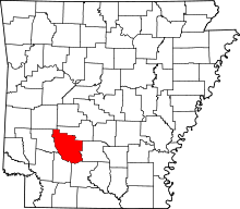 Location in the U.S. state of Arkansas | |
 Arkansas's location in the U.S. | |
| Founded | December 15, 1818 |
| Named for | William Clark |
| Seat | Arkadelphia |
| Largest city | Arkadelphia |
| Area | |
| • Total | 883 sq mi (2,287 km2) |
| • Land | 866 sq mi (2,243 km2) |
| • Water | 17 sq mi (44 km2), 1.9% |
| Population (est.) | |
| • (2015) | 22,633 |
| • Density | 27/sq mi (10/km²) |
| Congressional district | 4th |
| Time zone | Central: UTC-6/-5 |
| Website |
www |
Clark County is a county located in the U.S. state of Arkansas. As of the 2010 census, the population was 22,995.[1] The county seat is Arkadelphia.[2] The Arkadelphia, AR Micropolitan Statistical Area includes all of Clark County.
History
Clark County was Arkansas' third county, formed on December 15, 1818, alongside Hempstead and Pulaski counties. The county is named after William Clark who at the time was Governor of the Missouri Territory, which included present-day Arkansas. On November 1, 1833, Pike County was created, out of western Clark County and part of northern Hempstead County by the Arkansas territorial legislature and named after Zebulon Pike. Arkadelphia was named as the county seat in 1842.
Geography
According to the U.S. Census Bureau, the county has a total area of 883 square miles (2,290 km2), of which 866 square miles (2,240 km2) is land and 17 square miles (44 km2) (1.9%) is water.[3]
Major highways
Adjacent counties
- Hot Spring County (northeast)
- Dallas County (east)
- Ouachita County (southeast)
- Nevada County (southwest)
- Pike County (west)
- Montgomery County (northwest)
Demographics
| Historical population | |||
|---|---|---|---|
| Census | Pop. | %± | |
| 1830 | 1,369 | — | |
| 1840 | 2,309 | 68.7% | |
| 1850 | 4,070 | 76.3% | |
| 1860 | 9,735 | 139.2% | |
| 1870 | 11,953 | 22.8% | |
| 1880 | 15,771 | 31.9% | |
| 1890 | 20,997 | 33.1% | |
| 1900 | 21,289 | 1.4% | |
| 1910 | 23,686 | 11.3% | |
| 1920 | 25,632 | 8.2% | |
| 1930 | 24,932 | −2.7% | |
| 1940 | 24,402 | −2.1% | |
| 1950 | 22,998 | −5.8% | |
| 1960 | 20,950 | −8.9% | |
| 1970 | 21,537 | 2.8% | |
| 1980 | 23,326 | 8.3% | |
| 1990 | 21,437 | −8.1% | |
| 2000 | 23,546 | 9.8% | |
| 2010 | 22,995 | −2.3% | |
| Est. 2015 | 22,633 | [4] | −1.6% |
| U.S. Decennial Census[5] 1790–1960[6] 1900–1990[7] 1990–2000[8] 2010–2015[1] | |||
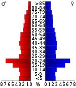
As of the 2000 United States Census,[10] there were 23,546 people, 8,912 households, and 5,819 families residing in the county. The population density was 27 people per square mile (10/km²). There were 10,166 housing units at an average density of 12 per square mile (5/km²). The racial makeup of the county was 74.28% White, 22.02% Black or African American, 0.46% Native American, 0.62% Asian, 0.04% Pacific Islander, 1.37% from other races, and 1.20% from two or more races. 2.40% of the population were Hispanic or Latino of any race.
There were 8,912 households out of which 29.80% had children under the age of 18 living with them, 49.80% were married couples living together, 12.20% had a female householder with no husband present, and 34.70% were non-families. 27.60% of all households were made up of individuals and 12.40% had someone living alone who was 65 years of age or older. The average household size was 2.38 and the average family size was 2.91.
In the county the population was spread out with 21.70% under the age of 18, 20.00% from 18 to 24, 23.80% from 25 to 44, 19.90% from 45 to 64, and 14.60% who were 65 years of age or older. The median age was 32 years. For every 100 females there were 92.70 males. For every 100 females age 18 and over, there were 88.90 males.
The median income for a household in the county was $28,845, and the median income for a family was $37,092. Males had a median income of $28,692 versus $19,886 for females. The per capita income for the county was $14,533. About 13.50% of families and 19.10% of the population were below the poverty line, including 20.90% of those under age 18 and 18.40% of those age 65 or over.
Government
| Year | GOP | DNC | Others |
|---|---|---|---|
| 2016 | 51.7% 4,398 | 42.4% 3,606 | 5.9% 501 |
| 2012 | 51.7% 4,343 | 45.3% 3,808 | 3.0% 255 |
| 2008 | 50.7% 4,608 | 46.9% 4,267 | 2.4% 219 |
| 2004 | 45.0% 4,144 | 54.2% 4,990 | 0.8% 77 |
| 2000 | 43.8% 3,776 | 54.0% 4,661 | 2.2% 189 |
Communities
Cities
- Amity
- Arkadelphia (county seat)
- Gurdon
Towns
Unincorporated communities
Townships
Note: Unlike most Arkansas counties, Clark County only has one single township. That township encompasses the entire county.
Townships in Arkansas are the divisions of a county. Each township includes unincorporated areas; some may have incorporated cities or towns within part of their boundaries. Arkansas townships have limited purposes in modern times. However, the United States Census does list Arkansas population based on townships (sometimes referred to as "county subdivisions" or "minor civil divisions"). Townships are also of value for historical purposes in terms of genealogical research. Each town or city is within one or more townships in an Arkansas county based on census maps and publications. The townships of Clark County are listed below; listed in parentheses are the cities, towns, and/or census-designated places that are fully or partially inside the township. [12][13]
- Caddo
Notable residents
- The Clark County town of Alpine was once a childhood home to Hollywood film star Billy Bob Thornton.
- Dallas Cowboys NFL great Cliff Harris played his college football for the Ouachita Baptist University football team.
- Though raised in Hot Spring County, Arkansas, rising country music star Jody Evans got his start in Clark County, and works for the Arkadelphia Police Department.
- Actor Daniel Davis, best known for playing "Niles the butler" in the television series The Nanny, was born in Gurdon.
- Two modern politicians had roots in Arkadelphia: former Lieutenant Governor Bob C. Riley, a Democrat who served from 1971–1975, and Jerry Thomasson, a former member of the Arkansas House of Representatives who switched to the Republican Party to run unsuccessfully for state attorney general in 1966 and 1968.
- Rex Nelson, former Political Editor of the Arkansas Democrat-Gazette, was born and raised in Arkadelphia.
See also
- List of lakes in Clark County, Arkansas
- National Register of Historic Places listings in Clark County, Arkansas
References
- 1 2 "State & County QuickFacts". United States Census Bureau. Retrieved May 20, 2014.
- ↑ "Find a County". National Association of Counties. Archived from the original on 2011-05-31. Retrieved 2011-06-07.
- ↑ "2010 Census Gazetteer Files". United States Census Bureau. August 22, 2012. Retrieved August 25, 2015.
- ↑ "County Totals Dataset: Population, Population Change and Estimated Components of Population Change: April 1, 2010 to July 1, 2015". Retrieved July 2, 2016.
- ↑ "U.S. Decennial Census". United States Census Bureau. Archived from the original on May 11, 2015. Retrieved August 25, 2015.
- ↑ "Historical Census Browser". University of Virginia Library. Retrieved August 25, 2015.
- ↑ Forstall, Richard L., ed. (March 27, 1995). "Population of Counties by Decennial Census: 1900 to 1990". United States Census Bureau. Retrieved August 25, 2015.
- ↑ "Census 2000 PHC-T-4. Ranking Tables for Counties: 1990 and 2000" (PDF). United States Census Bureau. April 2, 2001. Retrieved August 25, 2015.
- ↑ Based on 2000 census data
- ↑ "American FactFinder". United States Census Bureau. Archived from the original on 2013-09-11. Retrieved 2011-05-14.
- ↑ "Dave Leip's Atlas of U.S. Presidential Elections". Retrieved November 18, 2016.
- ↑ 2011 Boundary and Annexation Survey (BAS): Clark County, AR (PDF) (Map). U. S. Census Bureau. Retrieved 2011-08-23.
- ↑ "Arkansas: 2010 Census Block Maps - County Subdivision". United States Census Bureau. Retrieved May 27, 2014.
External links
- 1st Arkansas Infantry Regiment, CSA, Company B
- Lt. Andrew J. Pitner and Pvt. Charles Trickett, CSA Medal of Honor
- Stanford-Sellers murder, 1893
- Clark County Sheriff's Office
 |
Hot Spring County | | ||
| Pike County | |
Dallas County | ||
| ||||
| | ||||
| Nevada County | Ouachita County |
Municipalities and communities of Clark County, Arkansas, United States | ||
|---|---|---|
| Cities | | |
| Towns | ||
| Unincorporated communities | ||
Coordinates: 34°05′20″N 93°09′50″W / 34.08889°N 93.16389°W