Roanoke metropolitan area
The Roanoke Metropolitan Statistical Area is a Metropolitan Statistical Area (MSA) in Virginia as defined by the United States Office of Management and Budget (OMB). The Roanoke MSA is sometimes referred to as the Roanoke Valley, even though the Roanoke MSA occupies a larger area than the Roanoke Valley. It is geographically similar to the area known as the Roanoke Region of Virginia, but while the latter includes Alleghany County, the former does not.[1] As of the 2000 census, the MSA had a population of 288,309 (though a July 1, 2009 estimate placed the population at 300,399).[2]
Figures through 2000 do not include Franklin County (50,345 est. 2005 population) and Craig County (5,154 est. 2005 population). The Census Bureau has since added them to the Roanoke MSA, which is the fourth largest in Virginia (behind Northern Virginia, Hampton Roads, and the Greater Richmond area), and the largest in the western half of the state. Its current rank is 201 among all 363 MSAs. The Roanoke, VA MSA population changed from 288,471 in 2000 to 298,694 in 2008, a 3.54 percent change. The population is projected to be 324,882 in 2020, a 12.62 percent change between 2000 and 2020.[3]
MSA components
Note: Since a state constitutional change in 1871, all cities in Virginia are independent cities that are not located in any county. The OMB considers these independent cities to be county-equivalents for the purpose of defining MSAs in Virginia.
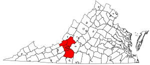
Four counties and two independent cities are included in the Roanoke Metropolitan Statistical Area.[4]
Politics
| Year | GOP | DEM | Others |
|---|---|---|---|
| 2012 | 57.3% 85,662 | 41.4% 61,885 | 1.3% 2,014 |
| 2008 | 54.6% 81,633 | 44.2% 66,098 | 1.2% 1,805 |
| 2004 | 60.0% 80,991 | 39.2% 52,901 | 0.9% 1,205 |
| 2000 | 55.8% 68,230 | 41.8% 51,032 | 2.4% 2,929 |
| 1996 | 53.1% 52,684 | 36.2% 35,922 | 10.7% 10,636 |
| 1992 | 45.1% 52,889 | 31.3% 43,360 | 13.6% 15,888 |
| 1988 | 56.0% 57,284 | 43.2% 44,244 | 0.8% 826 |
| 1984 | 60.9% 63,591 | 38.5% 40,207 | 0.6% 642 |
| 1980 | 49.1% 47,377 | 46.1% 44,405 | 4.7% 4,570 |
| 1976 | 43.9% 39,942 | 54.7% 49,783 | 1.4% 1,301 |
| 1972 | 70.4% 53,364 | 27.4% 20,777 | 2.2% 1,672 |
| 1968 | 52.2% 37,977 | 25.1% 18,268 | 22.6% 16,439 |
| 1964 | 48.3% 28,732 | 63.0% 30,713 | 0.1% 44 |
| 1960 | 60.7% 29,010 | 39.0% 18,638 | 0.3% 122 |
Communities
Places with more than 90,000 inhabitants
- Roanoke (Principal city)
Places with 10,000 to 30,000 inhabitants
- Cave Spring (census-designated place)
- Hollins (census-designated place)
- Salem
Places with 1,000 to 10,000 inhabitants
- Blue Ridge (census-designated place)
- Buchanan
- Cloverdale (census-designated place)
- Daleville (census-designated place)
- Ferrum (census-designated place)
- Laymantown (census-designated place)
- North Shore (census-designated place)
- Rocky Mount
- Vinton
Places with less than 1,000 inhabitants
- Boones Mill
- Fincastle
- New Castle
- Penhook (census-designated place)
- Troutville
- Union Hall (census-designated place)
- Westlake Corner (census-designated place)
Unincorporated places
|
|
|
Demographics
As of the census[5] of 2000, there were 288,309 people, 119,366 households, and 80,009 families residing within the MSA. The racial makeup of the MSA was 84.96% White, 12.21% African American, 0.17% Native American, 1.05% Asian, 0.02% Pacific Islander, 0.47% from other races, and 1.12% from two or more races. Hispanic or Latino of any race were 1.13% of the population.
The median income for a household in the MSA was $40,251, and the median income for a family was $47,248. Males had a median income of $32,294 versus $23,427 for females. The per capita income for the MSA was $20,390.
See also
References
- ↑ Roanoke Region of Virginia
- ↑ "Table 1. Annual Estimates of the Population of Metropolitan and Micropolitan Statistical Areas: April 1, 2000 to July 1, 2009 (CBSA-EST2009-01)" (CSV). 2009 Population Estimates. United States Census Bureau, Population Division. 2010-03-23. Retrieved 2010-03-26.
- ↑ "Roanoke, VA MSA Demographic-Economic Situation & Outlook". Proximityone.com. Retrieved 2009-08-27.
- ↑ "Metropolitan Statistical Areas and Components" (TXT). Metropolitan statistical areas and metropolitan divisions defined by the Office of Management and Budget, November 2007. United States Census Bureau, Population Division. 2008-06-24. Retrieved 2008-09-03.
- ↑ "American FactFinder". United States Census Bureau. Retrieved 2008-01-31.