Floyd County, Virginia
| Floyd County, Virginia | ||
|---|---|---|
|
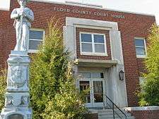
Floyd County Courthouse | ||
| ||
 Location in the U.S. state of Virginia | ||
 Virginia's location in the U.S. | ||
| Founded | 1831 | |
| Named for | John Floyd | |
| Seat | Floyd | |
| Largest town | Floyd | |
| Area | ||
| • Total | 382 sq mi (989 km2) | |
| • Land | 381 sq mi (987 km2) | |
| • Water | 0.9 sq mi (2 km2), 0.2% | |
| Population (est.) | ||
| • (2015) | 15,279 | |
| • Density | 41/sq mi (16/km²) | |
| Congressional district | 9th | |
| Time zone | Eastern: UTC-5/-4 | |
| Website |
www | |

Floyd County is a county located in the Commonwealth of Virginia. As of the 2010 census, the population was 15,279.[1] Its county seat is Floyd.[2]
Floyd County is included in the Blacksburg-Christiansburg-Radford, VA Metropolitan Statistical Area.
History

Floyd County's recorded history begins with the arrival of traders, trappers and hunters in Southwest Virginia in the 18th century. The earliest known travel way through present day Floyd County was the Trader's Path, running from east to west across the Roanoke River where Back Creek enters the river, by John Mason's, R. Poage's, the headwaters of Back Creek and southwest over Bent Mountain. The trail continued westward through the Little River area to the Lead Mines.
The first known attempts to settle the area appear to have been made during the 1740s. In 1745 the Virginia Council granted James Patton, of Augusta County, among others, 100,000 acres (400 km2) on the New River and the westward flowing waters, including the Little River area. In 1749 the Royal Company of Virginia also received a grant on the westward flowing waters, putting the two companies in competition with one another to settle the area. The first surveying of the land occurred in the late 1740s.[3]
On January 15, 1831, the General Assembly of Virginia passed an act creating the present county of Floyd out of the county Montgomery. The new county was named for the then Governor of Virginia, John Floyd.[4] The new county's courthouse was completed in 1834. In 1870 a portion of Franklin County was added to Floyd County. The first Commonwealth's Attorney was William Ballard Preston, a nephew of John Floyd, who would later serve as Secretary of the United States Navy. Preston was followed in later years by Jubal Early, who would later serve as a general for the Confederate Army.[5]
The county seat of Floyd County was first called Jacksonville for Andrew Jackson, seventh President of the United States (1829–1837). Jacksonville was first incorporated in 1858 and then re-incorporated on February 19, 1892 to expand the town boundaries. On January 23, 1896, the General Assembly passed an Act officially changing the name of the Town of Jacksonville to the town of Floyd.
The county became a destination for those involved in the counterculture during the 1960s and 1970s, particularly those who wanted to live in closer contact with nature.[6] In the late 1990s, the Rivendell community was established by a group of Christians so they could practice a lifestyle consistent with their Reformed Churches' interpretations of the Bible and also, in part, to be better isolated from possible societal disruptions caused by the Y2K computer problem. Most of the original members of this community have moved on.
Floyd County was also a setting for the ministry of Reverend Bob Childress, whose life was chronicled in the book The Man Who Moved a Mountain.
The county's location directly adjacent to both the Roanoke and the Blacksburg-Christiansburg-Radford Metropolitan Statistical Areas have contributed to modest population growth in contrast to most rural counties in Southwest Virginia. Several bloggers live in the county and frequently post observations about the community and its rural setting.[7]
Floyd County also has a strong music and literary scene. Three establishments in Floyd regularly offer a variety of live music during the weekends ranging from traditional styles such as Bluegrass and Old-timey_music to contemporary and alternative acts. Best known is the Friday Night Jamboree held at The Floyd Country Store.[8] Both the Country Store and County Records, founded in the 1960s,[9] are featured on the Virginia Heritage Music Trail called "The Crooked Road."[10] In the early 21st century, Floyd became the home of an annual world music festival called FloydFest.
The Chateau Morrisette and Villa Appalaccia wineries have been established since the 1980s.
Geography
According to the United States Census Bureau, the county has a total area of 381.8 square miles (988.9 km2), of which 380.9 square miles (986.5 km2) is land and 0.9 square miles (2.3 km2) (0.2%) is water.[11] It is located in the Blue Ridge Mountains of southwestern Virginia.
The county seat, the town of Floyd, is 40 miles (64 km) southwest of Roanoke on US 221. Buffalo Mountain, at 3,971 feet (1,210 m), is the highest point in the county.
Floyd County is situated atop a high plateau of the Blue Ridge Mountains which divides the eastward flowing from the westward flowing waters. With the high topography, no streams flow into Floyd County. The county is drained primarily by Little River and its tributaries which flow into New River below the Claytor Lake Dam and, in turn, by way of the Kanawha River, the Ohio River and the Mississippi River, into the Gulf of Mexico. The headwaters of the south fork of the Roanoke River are in the northeastern part of the county. No water flows into Floyd County - it all flows out - one particular fast stream is Shooting Creek. Named for its speed over rocks. This creek today follows Shooting Creek Road from Floyd into Franklin County. In later years, it would become the site of moonshine liquor distilleries and the lawlessness that surrounded this industry.
Adjacent counties
- Franklin County, Virginia – east
- Patrick County, Virginia – southeast
- Carroll County, Virginia – southwest
- Pulaski County, Virginia – northwest
- Montgomery County, Virginia – northwest
- Roanoke County, Virginia – north
National protected area
Major highways
Demographics
| Historical population | |||
|---|---|---|---|
| Census | Pop. | %± | |
| 1840 | 4,453 | — | |
| 1850 | 6,458 | 45.0% | |
| 1860 | 8,236 | 27.5% | |
| 1870 | 9,824 | 19.3% | |
| 1880 | 13,255 | 34.9% | |
| 1890 | 14,405 | 8.7% | |
| 1900 | 15,388 | 6.8% | |
| 1910 | 14,092 | −8.4% | |
| 1920 | 13,115 | −6.9% | |
| 1930 | 11,698 | −10.8% | |
| 1940 | 11,967 | 2.3% | |
| 1950 | 11,351 | −5.1% | |
| 1960 | 10,462 | −7.8% | |
| 1970 | 9,775 | −6.6% | |
| 1980 | 11,563 | 18.3% | |
| 1990 | 12,005 | 3.8% | |
| 2000 | 13,874 | 15.6% | |
| 2010 | 15,279 | 10.1% | |
| Est. 2015 | 15,651 | [12] | 2.4% |
| U.S. Decennial Census[13] 1790-1960[14] 1900-1990[15] 1990-2000[16] 2010-2015[1] | |||
As of the census[17] of 2000, there were 13,874 people, 5,791 households, and 4,157 families residing in the county. The population density was 36 people per square mile (14/km²). There were 6,763 housing units at an average density of 18 per square mile (7/km²). The racial makeup of the county was 96.71% White, 2.00% Black or African American, 0.09% Native American, 0.09% Asian, 0.01% Pacific Islander, 0.36% from other races, and 0.74% from two or more races. 1.35% of the population were Hispanic or Latino of any race.
There were 5,791 households out of which 29.10% had children under the age of 18 living with them, 59.90% were married couples living together, 8.10% had a female householder with no husband present, and 28.20% were non-families. 24.70% of all households were made up of individuals and 10.80% had someone living alone who was 65 years of age or older. The average household size was 2.39 and the average family size was 2.83.
In the county, the population was spread out with 22.20% under the age of 18, 6.90% from 18 to 24, 27.60% from 25 to 44, 27.40% from 45 to 64, and 15.90% who were 65 years of age or older. The median age was 40 years. For every 100 females there were 97.50 males. For every 100 females age 18 and over, there were 96.70 males.
The median income for a household in the county was $31,585, and the median income for a family was $38,128. Males had a median income of $30,886 versus $20,466 for females. The per capita income for the county was $16,345. About 8.50% of families and 11.70% of the population were below the poverty line, including 12.70% of those under age 18 and 15.30% of those age 65 or over.
Government
Board of Supervisors
District A (Locust Grove District): Lauren David Yoder (R)
District B (Little River District): Linda DeVito Kuchenbuch (I)
District C (Courthouse District): Case C. Clinger (R)
District D (Burks Fork District): Joe D. Turman (R)
District E (Indian Valley District): John F. Gerald (R)
Constitutional Officers
Clerk of the Circuit Court: Wendell G. Peters (R)
Commissioner of the Revenue: Lisa Dawn Baker (R)
Commonwealth's Attorney: Eric Branscom
Sheriff: Brian Craig (R)
Treasurer: Melissa M. "Missy" Keith (R)
Floyd is represented by Republican Ralph K. Smith in the Virginia Senate, Republican Larry N. "Nick" Rush in the Virginia House of Delegates, and Republican H. Morgan Griffith in the U.S. House of Representatives.
Communities
|
|
|
See also
References
- 1 2 "State & County QuickFacts". United States Census Bureau. Retrieved January 2, 2014.
- ↑ "Find a County". National Association of Counties. Retrieved 2011-06-07.
- ↑ http://www.floydcova.org/visitors/history.shtml
- ↑ McDonald, James J. (1907). Life in Old Virginia, p. 368. The Old Virginia Publishing Co. (Inc.)
- ↑ http://www.floydcova.org/visitors/history_floyd_county.pdf
- ↑ Blackwell, Mary Alice & Causey, Anne Patterson (9th ed. 2005). Insider's Guide to Virginia's Blue Ridge, p. 39. The Globe Pequot Press.
- ↑ Floyd County Local History http://www.floydcountyinview.com/countyfacts_history.htm
- ↑ Floyd Country Store http://floydcountrystore.com
- ↑ County Records http://www.countysales.com/pages.php?pageid=2
- ↑ The Crooked Road http://thecrookedroad.org/
- ↑ "US Gazetteer files: 2010, 2000, and 1990". United States Census Bureau. 2011-02-12. Retrieved 2011-04-23.
- ↑ "County Totals Dataset: Population, Population Change and Estimated Components of Population Change: April 1, 2010 to July 1, 2015". Retrieved July 2, 2016.
- ↑ "U.S. Decennial Census". United States Census Bureau. Retrieved January 2, 2014.
- ↑ "Historical Census Browser". University of Virginia Library. Retrieved January 2, 2014.
- ↑ "Population of Counties by Decennial Census: 1900 to 1990". United States Census Bureau. Retrieved January 2, 2014.
- ↑ "Census 2000 PHC-T-4. Ranking Tables for Counties: 1990 and 2000" (PDF). United States Census Bureau. Retrieved January 2, 2014.
- ↑ "American FactFinder". United States Census Bureau. Retrieved 2011-05-14.
External links
- County Government Page
- Floyd Virginia Online
- Floyd County Chamber of Commerce
- Floyd County Directory on line
- The Floyd Country Store
- Floyd Tourism Directory
- Floyd Fest
- The Floyd Blog
- Chantilly Festival Farm
 |
Pulaski County and Montgomery County | Roanoke County | | |
| |
Franklin County | |||
| ||||
| | ||||
| Carroll County | Patrick County |
Municipalities and communities of Floyd County, Virginia, United States | ||
|---|---|---|
| Town | | |
| Unincorporated communities | ||
Coordinates: 36°56′N 80°22′W / 36.94°N 80.36°W