Lancaster County, Virginia
| Lancaster County, Virginia | |
|---|---|
|
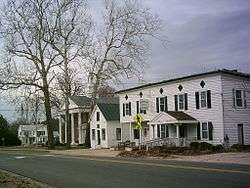
Central Lancaster, the county seat, with the county courthouse visible | |
 Location in the U.S. state of Virginia | |
 Virginia's location in the U.S. | |
| Founded | 1651 |
| Seat | Lancaster |
| Largest town | Kilmarnock |
| Area | |
| • Total | 231 sq mi (598 km2) |
| • Land | 133 sq mi (344 km2) |
| • Water | 98 sq mi (254 km2), 42.4% |
| Population (est.) | |
| • (2015) | 10,965 |
| • Density | 88/sq mi (34/km²) |
| Congressional district | 1st |
| Time zone | Eastern: UTC-5/-4 |
| Website |
www |
Lancaster County is a county located on the Northern Neck in the Commonwealth of Virginia. As of the 2010 census, the population was 11,391.[1] Its county seat is Lancaster.[2]
Located on the Northern Neck near the mouth of the Rappahannock River, Lancaster County is part of the Northern Neck George Washington Birthplace wine-growing region recognized by the United States as an American Viticultural Area. Lancaster County is the most densely populated county in the Northern Neck. The largest town in Lancaster County is Kilmarnock, Virginia. The county's area code is '804'.
History
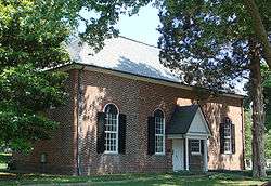
Lancaster County was established in 1651 from Northumberland and York counties. It was home to Robert King Carter in the 18th century, and remaining buildings from that time include Christ Church and St. Mary's, Whitechapel. Other historic attractions open to the public include the Lancaster Courthouse Historic District including the Mary Ball Washington Museum and Library, Belle Isle State Park, and the Village of Morattico Historic District.
Geography
According to the U.S. Census Bureau, the county has a total area of 231 square miles (600 km2), of which 133 square miles (340 km2) is land and 98 square miles (250 km2) (42.4%) is water.[3]
Adjacent counties
- Richmond County – northwest
- Northumberland County – north
- Middlesex County – south and southwest
Demographics
| Historical population | |||
|---|---|---|---|
| Census | Pop. | %± | |
| 1790 | 5,638 | — | |
| 1800 | 5,375 | −4.7% | |
| 1810 | 5,592 | 4.0% | |
| 1820 | 5,517 | −1.3% | |
| 1830 | 4,801 | −13.0% | |
| 1840 | 4,628 | −3.6% | |
| 1850 | 4,708 | 1.7% | |
| 1860 | 5,151 | 9.4% | |
| 1870 | 5,355 | 4.0% | |
| 1880 | 6,160 | 15.0% | |
| 1890 | 7,191 | 16.7% | |
| 1900 | 8,949 | 24.4% | |
| 1910 | 9,752 | 9.0% | |
| 1920 | 9,757 | 0.1% | |
| 1930 | 8,896 | −8.8% | |
| 1940 | 8,786 | −1.2% | |
| 1950 | 8,640 | −1.7% | |
| 1960 | 9,174 | 6.2% | |
| 1970 | 9,126 | −0.5% | |
| 1980 | 10,129 | 11.0% | |
| 1990 | 10,896 | 7.6% | |
| 2000 | 11,567 | 6.2% | |
| 2010 | 11,391 | −1.5% | |
| Est. 2015 | 10,965 | [4] | −3.7% |
| U.S. Decennial Census[5] 1790–1960[6] 1900–1990[7] 1990–2000[8] 2010–2013[1] | |||
As of the census[9] of 2000, there were 11,567 people, 5,004 households, and 3,412 families residing in the county. The population density was 87 people per square mile (34/km²). There were 6,498 housing units at an average density of 49 per square mile (19/km²). The racial makeup of the county was 69.95% White, 28.88% Black or African American, 0.14% Native American, 0.34% Asian, 0.06% Pacific Islander, 0.10% from other races, and 0.54% from two or more races. 0.61% of the population were Hispanic or Latino of any race.
There were 5,004 households out of which 21.20% had children under the age of 18 living with them, 54.70% were married couples living together, 11.10% had a female householder with no husband present, and 31.80% were non-families. 28.70% of all households were made up of individuals and 16.80% had someone living alone who was 65 years of age or older. The average household size was 2.23 and the average family size was 2.71.
In the county, the population was spread out with 19.00% under the age of 18, 5.00% from 18 to 24, 19.60% from 25 to 44, 28.00% from 45 to 64, and 28.50% who were 65 years of age or older. The median age was 50 years. For every 100 females there were 86.80 males. For every 100 females age 18 and over, there were 81.50 males.
Type of workers for this country are: Private wage or salary (72%); Government (15%); and Self-employed (12%).[10] The median income for a household in the county was $33,239, and the median income for a family was $42,957. Males had a median income of $30,592 versus $23,039 for females. The per capita income for the county was $24,663. Approximately 9.90% of families and 12.50% of the population were below the poverty line, including 18.00% of those under age 18 and 11.20% of those age 65 or over.
Government
Lancaster County is governed by a five-member board of supervisors. The board meets in the Lancaster County Administration Building at 7 p.m. on the last Thursday of every month. The Administration building is located at 8311 Mary Ball Road in Lancaster, Virginia.[11]
Current board of supervisors
- District 1: F. W. "Butch" Jenkins, Jr. (R)
- District 2: Ernest W. Palin, Jr. (I)
- District 3: Jason D. Bellows, Vice Chair (I)
- District 4: Jack S. Russell (I)
- District 5: B. Wally Beauchamp, Chair (R)
Current constitutional officers
Clerk of the Circuit Court: Diane H. Mumford (I) Commissioner of the Revenue: George E. "Sonny" Thomas (R) Commonwealth Attorney: Jan Smith (D) Sheriff: Patrick McCranie (R) Treasurer: Bonnie J.D. Haynie
Lancaster is represented by Republican Ryan T. McDougle in the Virginia Senate, Republican Margaret Bevans Ransone in the Virginia House of Delegates, and Republican Robert J. "Rob" Wittman in the U.S. House of Representatives.
Communities
Towns
Unincorporated communities
Landmarks and attractions
Lancaster County is home to the historic church of St. Mary's, Whitechapel, founded in 1669. Mary Ball Washington, mother of George Washington, was born in the parish of St. Mary's. Rappahannock General Hospital is in Kilmarnock, it is the only hospital on the Northern Neck. Other attractions are:
- King Carter Golf Course,
- Golden Eagle Golf Course,
- Irvington Steamboat Museum,
- Indian Creek Yacht and Country Club,
- The Tides Inn Resort Hotel,
- White Stone Beach,
- Windmill Point Beach,
- Chesapeake Boat Basin Marina,
- Belle Isle State Park,
- Chilton Woods State Forest,
- Carters Cove Marina,
- Kellum Seafood Oyster House,
- Rappahannock River Yacht Club,
- Ampro Shipyard,
- Historic Christ Church,
See also
References
- 1 2 "State & County QuickFacts". United States Census Bureau. Retrieved January 3, 2014.
- ↑ "Find a County". National Association of Counties. Retrieved 2011-06-07.
- ↑ "US Gazetteer files: 2010, 2000, and 1990". United States Census Bureau. 2011-02-12. Retrieved 2011-04-23.
- ↑ "County Totals Dataset: Population, Population Change and Estimated Components of Population Change: April 1, 2010 to July 1, 2015". Retrieved July 2, 2016.
- ↑ "U.S. Decennial Census". United States Census Bureau. Retrieved January 3, 2014.
- ↑ "Historical Census Browser". University of Virginia Library. Retrieved January 3, 2014.
- ↑ "Population of Counties by Decennial Census: 1900 to 1990". United States Census Bureau. Retrieved January 3, 2014.
- ↑ "Census 2000 PHC-T-4. Ranking Tables for Counties: 1990 and 2000" (PDF). United States Census Bureau. Retrieved January 3, 2014.
- ↑ "American FactFinder". United States Census Bureau. Retrieved 2011-05-14.
- ↑ http://www.city-data.com/county/Lancaster_County-VA.html#ixzz17Ma9eo5X
- ↑ www.lancova.com Retrieved 17 May 2014
 |
Richmond County | Northumberland County | | |
| |
Chesapeake Bay | |||
| ||||
| | ||||
| Middlesex County | Middlesex County |
Municipalities and communities of Lancaster County, Virginia, United States | ||
|---|---|---|
| Towns | | |
| Unincorporated communities |
| |
| Footnotes | ‡This populated place also has portions in an adjacent county or counties | |
Coordinates: 37°43′N 76°25′W / 37.71°N 76.41°W