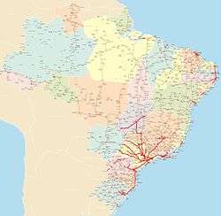
Brazilian Highway System
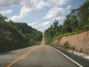
The Brazilian Highway System (Portuguese: Sistema Nacional de Rodovias) is the highway system of Brazil. As of 2010, the system consists of almost 2 million kilometers of roads, of which approximately 200,000 km are paved.
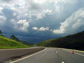
As it is in the United States, Canada or most countries in Europe, larger/wider highways have higher speed limits than normal urban roads (typically between 80 km/h and 120 km/h), although minor highways, unpaved highways and sections of major highways running inside urban areas have a lower speed limit in general. The national speed limit for cars driving in non-urban roads is 110 km/h unless otherwise stated, regardless of the road design, weather or daylight.
Nomenclature
Brazilian Regional highways are named YY-XXX, where YY is the abbreviation of the state where the highway is running in and XXX is a number (e.g. SP-280; where SP means that the highway is under São Paulo state administration).
Brazilian National highways are named BR-XXX. National highways connect multiple states altogether, are of major importance to the national economy and/or connect Brazil to another country. The meaning of the numbers are:
- 000-099 - it means that the highway runs radially from Brasília. It is an exception to the cases below.
- 100-199 - it means that the highway runs in a south-north way
- 200-299 - it means that the highway runs in a west-east way
- 300-399 - it means that the highway runs in a diagonal way. Highways with odd numbers run northeast-southwest, while even numbers run northwest-southeast.
- 400-499 - it means that the highway interconnects two major highways.
Often Brazilian highways receive names (famous people, etc.), but continue to have a YY/BR-XXX name (example: Rodovia Castelo Branco is also SP-280).
See highway system of São Paulo for numbering designation for São Paulo state roads, also used in some other states.
Growth, net density, importance and problems
In 1953, Adhemar de Barros, then governor of São Paulo, finished Via Anchieta, linking Santos to São Paulo, and Via Anhanguera, linking São Paulo to Campinas, two highways using the most modern standards of that time. It would be the major accomplishment on the area for years.
When Juscelino Kubitschek assumed the presidency, he created subsidies to bring multinationals like Volkswagen to Brazil and created thousand of miles of roads, linking distant regions of the country. Most of these roads follow poor standards, but they created links where there were none. The military presidents would mostly follow these same standards to expand the system. The exceptions would be the modern highways built by the São Paulo State Government.
In 1967, the first stretch of Via Castelo Branco (SP-280), a 2X3 and 2X2 limited-access highway built at par with standards drawn by FHWA, linking the city of São Paulo to the western region of the São Paulo State, was finished, creating a standard for other highways in the same state. In the same year, the Via Dutra was modernized, allowing a fast and modern trip between São Paulo and Rio de Janeiro.
The country would reach 200,000 km paved in 2000. Between 1995 and 2005 three major highways (BR-101, linking Curitiba to Porto Alegre; Via Regis Bittencourt, linking São Paulo to Curitiba; and Via Fernão Dias, linking São Paulo to Belo Horizonte) were modernized. Until then, most of these highways were known for their high mortality rate due to traffic accidents.
The Southern and Southeast regions of Brazil are heavily connected by highways, most of them paved; the North region is the least connected with paved highways due to the presence of the Amazon rainforest. In this region, highways, when they are present, generally are unpaved. Manaus, for example, has no major paved highways connecting it to any other city but Boa Vista in the north.
Motorways
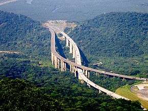
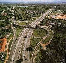
Due to the country's growth and the associated traffic increase, the Government has started the construction and adaptation of main road sections into motorways. The first one to be completed was the so-called Via Dutra (BR-116), the important highway connecting São Paulo to Rio de Janeiro, which was finished on the 1975 with a 2X2 setting, but retained some grade crossings. Later, other roads were built or expanded to dual carriageways, like the Via Fernão Dias, connecting Belo Horizonte to São Paulo; the Via Bandeirantes, connecting São Paulo to the State's countryside; the Via Litoral Sul, connecting Curitiba to Florianópolis, and a few others.
Nowadays, the Government and the private sector are planning to duplicate thousands of kilometers, with few hundreds already on their way. For example, the first section of the Northeastern Corridor, connecting the capital city of Natal to Palmares, southern of Pernambuco State, the road connecting Goiânia to Uberlândia, this one on the west of Minas Gerais state, the road connecting Palhoça, on Florianópolis Metropolitan Area, to Osório, a city 90 km west from Porto Alegre, already connected by a dual, modern, six lane carriageway road, and few others.
The projects are the link between Brasília and Belo Horizonte (800 km), Belo Horizonte and Juiz de Fora (close to the Minas Gerais-Rio de Janeiro State Border), with 200 km, the Rio-Bahia Road System, between Três Rios (app. 150 km from Rio de Janeiro City, already connected to the State Capital by a dual carriageway road) and Feira de Santana (app. 200 km from Salvador, also connected by a dual carriageway road), and the important connection between Palmares and Salvador.
The majority of these roads are or are going to be tolled roads maintained by the private concessionaires (like the link between Florianópolis and Belo Horizonte, or the link between Rio de Janeiro and Salvador, or even the link between Rio de Janeiro and São Paulo), however, some roads, like the link between Salvador and Natal, which will be more than a 1,000 km long of a full dual carriageway system, will not, by the next few years, be tolled, and will link, more likely by 2014, 70% of all the economy and the population of the Northeast Region.
Public vs. private administration
Brazilian highways are under constant observation (laws, rules, highway patrolling) of CONTRAN (Conselho Nacional de Trânsito - National Transit (Road Transportation) Council), the national government organization responsible for the rules and laws of the Brazilian road system (including all the ones inside urban areas), and DENATRAN (Departamento Nacional de Trânsito - National Road Transport Department), the national government organization responsible for enforcing these laws, but funding it is a government (from the state where the highways is/passes by) or private responsibility. All major Brazilian paved highways have toll roads.
In the 1990s, many state governments decided to privatize public-controlled paved highways, in order to generate extra income to the state's budget (for social care mainly). These governments argued that private funding would make problematic highways much better, because of the investments received. In fact, many private-controlled paved highways are in very good condition (with many of them having critical problems before), but other people argue that private-controlled paved highways charge more at the toll stations and that these highways have more toll stations than public-controlled paved highways (in order to compensate for the investment done).
Major Federal Brazilian Highways

BR-010

The BR-010 is a radial highway that connects the national capital Brasília, to the city of Belém, in the state of Pará. It has the official name of Rodovia Bernardo Sayão (the name of its chief engineer, who died in an accident during the construction of the highway, when a tree fell on him), and is also called as Belém-Brasília Highway or as Transbrasiliana Highway, in the stretch between the city of Estreito, in the state of Maranhão, and the city of Belém. This is due to the fact that between Brasília and Estreito, the highway has many incomplete and unpaved stretches, especially in the state of Tocantins. Between Brasília] and Estreito, the original route of the Belém-Brasília Highway follows the BR-060, the BR-153 and the BR-226 highways, which are completely paved in this stretch. The BR-010 passes through the Federal District, and the states of Goiás, Tocantins, Maranhão and Pará.
BR-040
BR-040 runs radially from near the national capital Brasília (beginning 100 km south of the beginning of BR-050, in Brasília), in a northwest-southeast way, to Rio de Janeiro city.
BR-040 is the modern way of the so-called "Caminho Novo", opened in the 18th century that linked Ouro Preto, the main center of gold mines of Minas Gerais to the Rio de Janeiro harbor.
In 1861 the road was paved from Petrópolis to Juiz de Fora, becoming the first road paved in Latin America until the 1920s. In 1928, Petrópolis was connected to Rio de Janeiro with a paved road.
In the 1930s the route was changed to pass by the new capital of Minas Gerais, Belo Horizonte, although it was unpaved until 1957, when the road was extended to Brasília, the new capital of Brazil.
From 1951 to 1973 BR-040 was called BR-3 and was famous for its dangerous bends, such as the Viaduto das Almas, near Belo Horizonte, disabled in 2010. In the 1970s the part from Rio de Janeiro to Juiz de Fora was modernized and became a two-laned road.
Cities where the BR-040 runs or passes by: Lusilândia, Belo Horizonte, Juiz de Fora, Rio de Janeiro.
BR-050

BR-050 runs radially from the national capital, Brasília, in a north-south way, to Santos city, passing in São Paulo.
Cities where the BR-050 runs or passes by: Brasília, Uberlândia and Uberaba. At the border of the state of São Paulo, it merges with Rodovia Anhanguera (SP-330) and passes by Ribeirão Preto, Limeira, Campinas and São Paulo, then it merges with Rodovia Anchieta (SP-150) and passes by São Bernardo do Campo and Santos.
BR-101

BR-101 runs in a north-south way, along Brazil's eastern coast. It is Brazil's second major highway, and the longest in the country (nearly 4800 km long). It connects more states capitals than any other "rodovia" in the country, in the total, 12 capitals are directly connected by BR-101.
The Rio–Niterói Bridge is part of the BR-101.
Cities where the BR-101 runs or passes by: Natal, João Pessoa, Olinda, Recife, Maceió, Aracaju, Feira de Santana, Itabuna, Ilhéus, Porto Seguro, Linhares, Vitória, Guarapari, Niterói, Rio de Janeiro, Barra Mansa, Santos, Curitiba, Joinville, Florianópolis, Criciúma, Osório.
BR-116
BR-116 runs in a north-south way, near, but not in Brazil's coastline. It is the major Brazilian highway, and it is the second longest of the country. Numerous parts of the long path taken by the BR-116 have other official names.
The highway is especially busy along the Joinville-Curitiba-São Paulo-Rio de Janeiro section. The Curitiba-São Paulo section of the highway is known as Rodovia Régis Bittencourt, nicknamed "Rodovia da Morte" (Highway of death), due to its many accidents caused by the unstable weather conditions of the region. The São Paulo-Rio de Janeiro section is named Rodovia Presidente Dutra, and it is the busiest section of the highway, running into or near of 15 cities with more than 200.000 inhabitants.
Cities where the BR-116 runs or passes by: Fortaleza, Salgueiro, Feira de Santana, Vitória da Conquista, Teófilo Otoni, Governador Valadares, Rio de Janeiro, Volta Redonda, São José dos Campos, São Paulo, Curitiba, Lages, Canoas, Porto Alegre.
BR-153
Also called as Transbrasiliana Highway, as Belém-Brasília Highway or even as Bernardo Sayão Highway, the BR-153 is one of the longest highways in South America and runs in the north-south direction, connecting the city of Marabá, in the state of Pará, and the city of Aceguá, in the boundary with Uruguay. It passes through the states of Pará, Tocantins, Goiás, Minas Gerais (Triângulo Mineiro region), São Paulo, Paraná, Santa Catarina and Rio Grande do Sul. The BR-153 is one of the main highways of the central region of Brazil, mainly in the states of Goiás and Tocantins, and also in the Triângulo Mineiro region.
BR-174
BR-174 is the only paved highway connecting Manaus to another Brazilian state capital. It starts in Manaus, passes into Jundiá, Novo Paraiso, Caracaraí, Mucajaí, Boa Vista, Roraima and Paracaima, in the extreme north of the country, connecting Brazil with the neighbouring country of Venezuela. And also to several villages in Venezuela, also crosses the Waimiri Atroari Indigenous Territory, located in the border between Amazonas and Roraima. This section of highway is closed at night and motorists are advised not to stop inside the reserve.
BR-230 (Rodovia Transamazônica)

BR-230 or Rodovia Transamazônica is Brazil's third longest highway, running in an east-west direction. It was planned and built in the late 1960s and the beginning of the 1970s, to connect the isolated state of Amazonas and region with the rest of the country.
It was planned to be more or less 8,000 km long, mostly paved and connecting the North and Northeast Brazilian regions and Ecuador and Peru, but nowadays it is 2,500 km long and mostly unpaved (dirt). BR-230 was inaugurated on August 30, 1972, and since then did not suffer any major alterations.
Other problems were the beginning of deforestation and the creation of numerous small villages along the highway, and traffic is impracticable during the rainy season of the year (October–March). Still, the highway is very important, by connecting the region with the rest of the country. A major plan to pave most of the highway is under consideration by the Brazilian government, as of 2004.
Cities where the highway run or passes by: Aguiarnópolis, Araguatins, Marabá, Altamira, Itaituba, Humaitá, Lábrea.
BR-232

BR-232 is a highway that runs east-west, starting in Recife - Pernambuco and goes up to west ending in Parnamirim. It is of major importance to Pernambuco, since it connects almost all its interior with the capital Recife to east and with the Amazonas region to west. It has double lanes between Recife and Caruaru ( 160 km W).
Major cities connected by the BR-232:Recife, Jaboatão dos Guararapes, Gravatá, Caruaru, Belo Jardim, Arcoverde, Serra Talhada, Salgueiro and Parnamirim. BR-232 is approximately 554 km long and inter-connects with 9 Federal Highways of vital importance to the Northeast of Brazil: BR-101, BR-408, BR-104, BR-423, BR-424, BR-110, BR-426, BR-116 and BR-316.
BR-277

BR-277 is a highway that runs east-west, starting from the Friendship Bridge (which connects Brazil with Paraguay) and goes up to Paranaguá. It is of major importance to Paraguay, since major importations are made using the Paranaguá seaport.
Major cities connected by the BR-277: Foz do Iguaçu, Medianeira, Cascavel, Guarapuava, Ponta Grossa, Curitiba, Paranaguá. BR-277 is approximately 650 km long.
BR-319
One of the two major highways connecting the isolated capital city of Manaus, it is mostly unpaved, and as a result, traffic is impracticable in the rainy seasons of the year. Despite this, BR-319 is a major highway of national significance because it connects Manaus to the southern regions of the country (which have greater population density).
Major cities connected by the BR-319: Manaus (by ferry from Careiro da Várzea), Caiero, Humaitá, Porto Velho.
BR-381
BR-381 or Rodovia Fernão Dias, as it is called, is a highway which runs in the Brazilian states of São Paulo and southern and eastern regions of Minas Gerais.
Major cities connected by the BR-381: São Paulo, Mairiporã, Atibaia, Pouso Alegre, Varginha, Oliveira, Belo Horizonte, João Monlevade, Timóteo, Coronel Fabriciano and Ipatinga.
Major state highways
State of São Paulo
-
 SP-340: Rodovia Adhemar de Barros
 -
 SP-150: Rodovia Anchieta
 -
 SP-330: Rodovia Anhangüera
 -
 SP-070: Rodovia Ayrton Senna
 -
 SP-348: Rodovia dos Bandeirantes
 -
 SP-326: Rodovia Brigadeiro Faria Lima
 - SP-070: Rodovia Carvalho Pinto
-
 SP-280: Rodovia Castelo Branco
 -
 SP-065: Rodovia Dom Pedro I
 -
 SP-160: Rodovia dos Imigrantes
 -
 SP-306: Rodovia Luiz de Queiroz
 -
 SP-300: Rodovia Marechal Cândido Rondon
 -
 SP-270: Rodovia Raposo Tavares
 -
 SP-075: Rodovia Santos Dumont
 -
 SP-310: Rodovia Washington Luís
 -
 SP-332: Rodovia Professor Zeferino Vaz
 -
 SP-099: Rodovia dos Tamoios
 -
 SP-123: Rodovia Floriano Rodrigues Pinheiro
 -
 SP-425: Rodovia Assis Chateaubriand
Notes and references
Bibliography
- (French) Michel Braudeau, « L'autoroute de l'amertume », in Le rêve amazonien, éditions Gallimard, 2004 (ISBN 2-07-077049-4).
External links
- (Portuguese) São Paulo Detran
| Rodovias radiais | |
|---|---|
| Rodovias longitudinais | |
| Rodovias transversais |
|
| Rodovias diagonais | |
| Rodovias de ligação |
|