Saint-Vaast-d'Équiqueville
| Saint-Vaast-d’Équiqueville | |
|---|---|
|
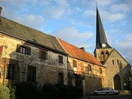
The church and manorhouse | |
 Saint-Vaast-d’Équiqueville | |
|
Location within Normandy region  Saint-Vaast-d’Équiqueville | |
| Coordinates: 49°49′06″N 1°15′59″E / 49.8183°N 1.2664°ECoordinates: 49°49′06″N 1°15′59″E / 49.8183°N 1.2664°E | |
| Country | France |
| Region | Normandy |
| Department | Seine-Maritime |
| Arrondissement | Dieppe |
| Canton | Envermeu |
| Intercommunality | Communauté de communes des Monts et Vallées |
| Government | |
| • Mayor (2014-2020) | Daniel Chauvet |
| Area1 | 14.04 km2 (5.42 sq mi) |
| Population (2011)2 | 670 |
| • Density | 48/km2 (120/sq mi) |
| Time zone | CET (UTC+1) |
| • Summer (DST) | CEST (UTC+2) |
| INSEE/Postal code | 76652 / 76510 |
| Elevation |
30–182 m (98–597 ft) (avg. 39 m or 128 ft) |
|
1 French Land Register data, which excludes lakes, ponds, glaciers > 1 km² (0.386 sq mi or 247 acres) and river estuaries. 2 Population without double counting: residents of multiple communes (e.g., students and military personnel) only counted once. | |
Saint-Vaast-d’Équiqueville is a commune in the Seine-Maritime department in the Haute-Normandie region in north-western France.
Geography
A farming village situated by the banks of the Béthune River in the Pays de Bray, some 12 miles (19 km) southeast of Dieppe at the junction of the D 1, D 22 and the D 14 roads.
Population
| Year | 1793 | 1962 | 1968 | 1975 | 1982 | 1990 | 1999 | 2006 | 2007 | 2011 |
|---|---|---|---|---|---|---|---|---|---|---|
| Population | 302 | 632 | 648 | 552 | 567 | 586 | 562 | 600 | 606 | 670 |
| From the year 1962 on: No double counting—residents of multiple communes (e.g. students and military personnel) are counted only once. | ||||||||||
Places of interest
- The manorhouse du Doyen (1657)
- The church of St. Vaast, dating from the eleventh century
- A sixteenth-century stone cross
People
- The artist Auguste Durst (1842–1930) stayed here from 1902 to 1907.
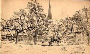
A sketch of the village by Auguste Durst
See also
References
External links
| Wikimedia Commons has media related to Saint-Vaast-d'Équiqueville. |
This article is issued from Wikipedia - version of the 9/17/2015. The text is available under the Creative Commons Attribution/Share Alike but additional terms may apply for the media files.