The Fort (Taft, California)
|
The Fort | |
 | |
  | |
| Location | Ash and Lincoln Sts., Taft, California |
|---|---|
| Coordinates | 35°9′2″N 119°27′54″W / 35.15056°N 119.46500°WCoordinates: 35°9′2″N 119°27′54″W / 35.15056°N 119.46500°W |
| Area | 4.1 acres (1.7 ha) |
| Built | 1938–40 |
| NRHP Reference # | 81000151[1] |
| Added to NRHP | July 22, 1981 |
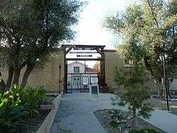
The Fort is a government building located at the intersection of Ash and Lincoln Sts. in Taft, California. The building is a replica of Sutter's Fort in Sacramento. The property is surrounded by 14-foot (4.3 m) tall adobe walls with large wooden entrance gates; the interior has a main building surrounded by a courtyard and several smaller offices. The Fort was built by the Works Progress Administration from 1938 to 1940 and was one of the largest WPA buildings constructed in the San Joaquin Valley. The buildings at The Fort have been used for government offices at the federal, state, and local levels.[2]
The Fort was added to the National Register of Historic Places on July 22, 1981.[1]
See also
- California Historical Landmarks in Kern County, California
- National Register of Historic Places listings in Kern County, California
References
- 1 2 National Park Service (2010-07-09). "National Register Information System". National Register of Historic Places. National Park Service.
- ↑ Mills, L. Dale (July 14, 1980). "National Register of Historic Places Inventory - Nomination Form: The Fort" (PDF). Heritage Conservation and Recreation Service. Retrieved April 20, 2013.
External links
| Topics | |
|---|---|
| Lists by states |
|
| Lists by insular areas | |
| Lists by associated states | |
| Other areas | |
| |
This article is issued from Wikipedia - version of the 11/30/2016. The text is available under the Creative Commons Attribution/Share Alike but additional terms may apply for the media files.