Albuquerque–Santa Fe–Las Vegas combined statistical area
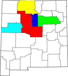
Location of the Albuquerque – Santa Fe – Las Vegas CSA and its components:
Albuquerque Metropolitan Area
Santa Fe Metropolitan Area
Las Vegas Micropolitan Area
Española Micropolitan Area
Grants Micropolitan Area
Los Alamos Micropolitan Area (it's near the top of the blue, near where the red and yellow meet)
The Albuquerque–Santa Fe–Las Vegas combined statistical area[1] (known as the Santa Fe–Española combined statistical area until 2013) is made up of nine counties in north central New Mexico. The combined statistical area consists of the Albuquerque and Santa Fe metropolitan statistical areas, and the Las Vegas, Los Alamos, Española, and Grants micropolitan statistical areas. As of the 2010 census, the CSA had a population of 1,146,049.[2] Roughly 55% of New Mexico's residents live in this area. Prior to the 2013 redefintions, the CSA consisted only of the Santa Fe metropolitan statistical area and the Española micropolitan statistical area.
Counties
- Bernalillo County
- Cibola County
- Los Alamos County
- Rio Arriba County
- Sandoval County
- San Miguel County
- Santa Fe County
- Torrance County
- Valencia County
Communities
Bernalillio County
- Albuquerque (Principal city)
- Carnuel
- Carpenter
- Cedar Crest
- Chilili
- Isleta Pueblo
- Isleta Village Proper
- Los Ranchos de Albuquerque
- Laguna Pueblo
- North Valley
- San Antonito
- South Valley
- Tijeras
- Zuzax
Cibola County
- Acoma Pueblo
- Acomita Lake
- Bibo
- Bluewater
- Bluewater Village
- Candy Kitchen
- Cebolleta
- Cebolletita
- Cubero
- Encinal
- Fence Lake
- Grants (City)
- Laguna
- Laguna Pueblo
- Mesita
- Milan
- Mountain View
- North Acomita Village
- Paguate
- Paraje
- Pinehill
- San Mateo
- San Rafael
- Seama
- Skyline-Ganipa
Los Alamos County
- Los Alamos (City)
- White Rock
Rio Arriba County
Sandoval County
San Miguel County
- Conchas Dam
- Las Ruedas
- Las Vegas (Principal city)
- Montezuma
- Mosquero
- North San Ysidro
- Pecos
- Ribera
- Rowe
- South San Ysidro
- Valles de San Geronimo
- Villanueva
Santa Fe County
- Agua Fria
- Cañada de los Alamos
- Cedar Grove
- Chimayó
- Chupadero
- Cuartelez
- Cundiyo
- Cuyamungue
- Edgewood
- El Rancho
- El Valle de Arroyo Seco
- Eldorado at Santa Fe
- Española (Part of)
- Galisteo
- Glorieta
- Jaconita
- La Cienega
- La Puebla
- Lamy
- Los Cerrillos
- Nambé Pueblo
- Madrid
- Pojoaque
- Rio Chiquito
- Rio en Medio
- San Ildefonso Pueblo
- Santa Cruz
- Santa Fe (Principal city)
- Seton Village
- Sombrillo
- Stanley
- Tesuque
- Waldo
Torrance County
Valencia County
See also
- List of metropolitan areas in New Mexico
- List of micropolitan areas in New Mexico
- List of cities in New Mexico
References
- ↑ EXECUTIVE OFFICE OF THE PRESIDENT - OFFICE OF MANAGEMENT AND BUDGET - OMB BULLETIN NO. 13-01 (February 28,2013)
- ↑ Population Change for Metropolitan and Micropolitan Statistical Areas in the United States and Puerto Rico (February 2013 Delineations): 2000 to 2010
 | ||
Santa Fe (capital) | |
| Topics |
|
| Society | |
| Regions | |
| Cities | |
| Counties | |
This article is issued from Wikipedia - version of the 6/20/2016. The text is available under the Creative Commons Attribution/Share Alike but additional terms may apply for the media files.