Alland'Huy-et-Sausseuil
| Alland'Huy-et-Sausseuil | ||
|---|---|---|
|
The Town Hall and School | ||
| ||
 Alland'Huy-et-Sausseuil | ||
|
Location within Grand Est region  Alland'Huy-et-Sausseuil | ||
| Coordinates: 49°30′48″N 4°33′23″E / 49.5133°N 4.5564°ECoordinates: 49°30′48″N 4°33′23″E / 49.5133°N 4.5564°E | ||
| Country | France | |
| Region | Grand Est | |
| Department | Ardennes | |
| Arrondissement | Vouziers | |
| Canton | Attigny | |
| Intercommunality | Crêtes Préardennaises | |
| Government | ||
| • Mayor (2008–2020) | Cédric Paté | |
| Area1 | 8.71 km2 (3.36 sq mi) | |
| Population (2009)2 | 247 | |
| • Density | 28/km2 (73/sq mi) | |
| Time zone | CET (UTC+1) | |
| • Summer (DST) | CEST (UTC+2) | |
| INSEE/Postal code | 08006 / 08130 | |
| Elevation |
77–121 m (253–397 ft) (avg. 100 m or 330 ft) | |
|
1 French Land Register data, which excludes lakes, ponds, glaciers > 1 km² (0.386 sq mi or 247 acres) and river estuaries. 2 Population without double counting: residents of multiple communes (e.g., students and military personnel) only counted once. | ||
Alland'Huy-et-Sausseuil is a French commune in the Ardennes department in the Grand Est region of northern France.
Geography
Alland'Huy-et-Sausseuil is located some 10 km east of Rethel and 35 km south-west of Charleville-Mézières. The D30 road from Amagne to Écordal passes through the northern part of the commune. The village can be accessed off the D30 via the D14 which passes through the village then continues east to Charbogne. There is also the D43 road from just south of Écordal which passes south through the commune to Saulces-Champenoises. A branch railway line passes through the commune from Lucquy station in the west to the station just south of the village and the line continues south-east to Attigny station. Apart from the village the commune consists entirely of farmland.[1]
La Foivre stream flows south through the eastern part of the commune and continues to join the Aisne south of the commune. There are several other small streams in the east of the commune and the Ruisseau de Saulces in the west.[1]
Neighbouring communes and villages[1]
 |
Sorcy-Bauthemont | Chesnois-Auboncourt | Écordal |  |
| Amagne | |
Charbogne | ||
| ||||
| | ||||
| Ambly-Fleury | Attigny |
History
This commune was occupied by the Germans during the First World War and again during the Second. The village was partially destroyed.
On 6 April 1944 six people were arrested on the Chesnois farm and deported for helping airmen of the U.S. Air Force, whose aircraft were shot down, to evade capture by the Germans.[2]
Heraldry
 |
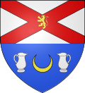
Blazon: Party per fesse, in chief argent saltire of gules charged with a lion of Or, in base azure a crescent of Or between two jugs argent handled and spouts facing. |
Administration
List of Successive Mayors[3]
| From | To | Name | Party | Position |
|---|---|---|---|---|
| 1864 | 1886 | Jean Auguste Pierlot | ||
| 1889 | 1892 | Michel Alphonse Coche | ||
| 1902 | 1907 | Jean Louis Cyrille Edmond Thille | ||
| 1913 | ? | Jean Baptiste Elie GÉNIN | ||
| 1931 | ? | Raoul Etienne Coche | ||
| 2001 | 2008 | Nadine Pamart | ||
| 2008 | 2011 | Laurent Danloup | ||
| 2011 | 2020 | Cédric Paté | Farmer |
(Not all data is known)
Demography
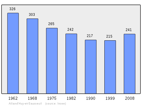
In 2009 the commune had 247 inhabitants. The evolution of the number of inhabitants is known through the population censuses conducted in the commune since 1793. From the 21st century, a census of communes with fewer than 10,000 inhabitants is held every five years, unlike larger towns that have a sample survey every year.[Note 1]
| 1793 | 1800 | 1806 | 1821 | 1831 | 1836 | 1841 | 1846 | 1851 |
|---|---|---|---|---|---|---|---|---|
| 385 | 399 | 449 | 493 | 612 | 672 | 646 | 643 | 591 |
| 1856 | 1861 | 1866 | 1872 | 1876 | 1881 | 1886 | 1891 | 1896 |
|---|---|---|---|---|---|---|---|---|
| - | - | 590 | 640 | 589 | 586 | 614 | 551 | 537 |
| 1901 | 1906 | 1911 | 1921 | 1926 | 1931 | 1936 | 1946 | 1954 |
|---|---|---|---|---|---|---|---|---|
| 548 | 524 | 522 | 529 | 463 | 431 | 431 | 341 | 372 |
| 1962 | 1968 | 1975 | 1982 | 1990 | 1999 | 2006 | 2009 | - |
|---|---|---|---|---|---|---|---|---|
| 326 | 303 | 265 | 242 | 217 | 215 | 235 | 247 | - |
Sources : Ldh/EHESS/Cassini until 1962, INSEE database from 1968 (population without double counting and municipal population from 2006)

Sites and Monuments
- The Church of Saint Catherine (12th century)
 is a Romanesque church located in the heart of the village. The building was listed as a historical monument in 1986.[4]
 - Some beautiful fortified farms, mostly made of brick.
- A Chateau in the hamlet of Sausseuil.
Notable people linked to the commune
- Charles Batteux (1713-1780) was a clergyman, Translator, Latin scholar, author of scholastic books. Professor of rhetoric. Held a Chair of Greek and Latin philosophy. Member of the Academy of Sciences in 1754.
- The French Resistance fighters arrested by the Gestapo at the Chesnois farm in 1944: the Fromentin family (Georges, Georgette, Jean, Lucienne), Paul Sagnet, Blanche Deloche-Sagnet, Charles Lambert, Robert Couvin.
See also
- Communes of the Ardennes department
- Cantons of the Ardennes department
- Arrondissements of the Ardennes department
External links
- Alland'Huy-et-Sausseuil on the old National Geographic Institute website (French)
- Alland'Huy-et-Sausseuil on Lion1906
- Alland'Huy-et-Sausseuil on Google Maps
- Alland'Huy-et-Sausseuil on Géoportail, National Geographic Institute (IGN) website (French)
- Allandhuy and Sausscuille on the 1750 Cassini Map
- Alland'Huy-et-Sausseuil on the INSEE website (French)
- INSEE (French)
Notes and references
Notes
- ↑ At the beginning of the 21st century, the methods of identification have been modified by law No. 2002-276 of 27 February 2002 , the so-called "law of local democracy" and in particular Title V "census operations" which allow, after a transitional period running from 2004 to 2008, the annual publication of the legal population of the different French administrative districts. For municipalities with a population greater than 10,000 inhabitants, a sample survey is conducted annually, the entire territory of these municipalities is taken into account at the end of the period of five years. The first "legal population" after 1999 under this new law came into force on 1 January 2009 and was based on the census of 2006.
References
- 1 2 3 Google Maps
- ↑ Alland'huy-et-Sausseuil: commemoration of the martyrs of March-April 1944, L'Union, 19 April 2011 (French)
- ↑ List of Mayors of France
- ↑ Ministry of Culture, Mérimée PA00078329 Church of Saint Catherine (French)

| Wikimedia Commons has media related to Alland'Huy-et-Sausseuil. |