Darjeeling district
| Darjeeling district দার্জিলিং জেলা दार्जिलिङग् जिल्ला | |
|---|---|
| District of West Bengal | |
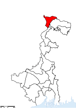 Location of Darjeeling district in West Bengal | |
| Country | India |
| State | West Bengal |
| Administrative division | Jalpaiguri |
| Headquarters | Darjeeling |
| Government | |
| • Lok Sabha constituencies | Darjeeling |
| • Assembly seats | Kalimpong, Darjeeling, Kurseong, Matigara-Naxalbari, Siliguri, Phansidewa |
| Area | |
| • Total | 3,149 km2 (1,216 sq mi) |
| Population (2011) | |
| • Total | 1,846,825 |
| • Density | 590/km2 (1,500/sq mi) |
| • Urban | 727,963 |
| Demographics | |
| • Literacy | 79.56% (excluding 0-6 population) |
| • Sex ratio | 970 |
| Major highways | NH 31, NH 55 |
| Website | Official website |
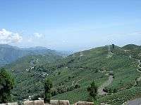
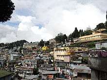
Darjeeling District (Bengali: দার্জিলিং জেলা; Nepali: दार्जिलिङग् जिल्ला) (pron: dɑ:rʤi:lɪŋ) is the northernmost district of the state of West Bengal in eastern India in the foothills of the Himalayas. The district is famous for its beautiful hill stations (often referred to as the Queen of the Hills) and Darjeeling tea. Darjeeling is the district headquarters.
Kalimpong, Kurseong and Siliguri, three other major towns in the district, are the subdivisional headquarters of the district. Mirik, another town of the district, has been developed as a lake resort since the late 1970s.
Geographically, the district can be divided into two broad divisions, the hills and the plains. The entire hilly region of the district comes under the Gorkhaland Territorial Administration, a semi-autonomous administrative body under the state government of West Bengal. This body covers the three hill subdivisions of Darjeeling, Kurseong and Kalimpong. The foothills of Darjeeling Himalayas, which comes under the Siliguri subdivision, is known as the Terai. The district is bounded on the north by Sikkim, on the south by Kishanganj district of Bihar state, on the east by Jalpaiguri district and on the west by Nepal. Darjeeling district has a length from north to south of 18 miles (29 km) and a breadth from east to west of 16 miles (26 km). As of 2011 it was the second least populous district of West Bengal (out of 19), after Dakshin Dinajpur.[1]
History
The name Darjeeling comes from the Tibetan words, Dorje (thunderbolt) and Ling (place or land), meaning the land of the thunderbolt. The history of Darjeeling district is linked to that of the Sikkim, East India Company, Nepal and Bhutan.
Most of Darjeeling formed a part of dominions of the Chogyal of Sikkim, who had been engaged in an unsuccessful warfare against the Gorkhas of Nepal. From 1780, the Gorkhas made several attempts to capture the entire region of Darjeeling. By the beginning of 19th century, they had overrun Sikkim as far eastward as the Teesta River and had conquered and annexed the Terai.
In the meantime, the British were engaged in preventing the Gorkhas from over-running the whole of the northern frontier. The Anglo-Gorkha war broke out in 1814, which resulted in the defeat of the Gorkhas and subsequently led to the signing of the Sugauli Treaty in 1815. According to the treaty, Nepal had to cede all those territories which the Gorkhas had annexed from the Chogyal of Sikkim to the British East India Company (i.e., the area between Mechi River and Teesta River). In 1817, through the Treaty of Titalia, the British East India Company reinstated the Chogyal of Sikkim, restored all the tracts of land between the Mechi and the Teesta rivers to the Chogyal of Sikkim and guaranteed his sovereignty. In 1835, the hill of Darjeeling, including an enclave of 138 square miles (360 km2), was given to the British East India Company by Sikkim.
In November 1864, the Treaty of Sinchula was executed in which the Bhutan Dooars with the passes leading into the hills and Kalimpong were ceded to the British by Bhutan. The Darjeeling district can be said to have assumed its present shape and size in 1866 with an area of 1234 sq. miles.
Before 1861 and from 1870–1874, Darjeeling District was a "Non-Regulated Area" (where acts and regulations of the British Raj did not automatically apply in the district in line with rest of the country, unless specifically extended). From 1862 to 1870, it was considered a "Regulated Area". The phrase "Non-Regulated Area" was changed to "Scheduled District" in 1874 and again to "Backward Tracts" in 1919. The status was known as "Partially Excluded Area" from 1935 until the independence of India.
Gorkhaland Movement
During the 1980s, the Gorkha National Liberation Front led an intensive and often violent campaign for the creation of a separate Gorkhaland state within India, across the Nepali-speaking areas in northern West Bengal. The movement reached its peak around 1986-1988 but ended with the establishment of the Darjeeling Gorkha Hill Council in 1988.
The hill areas of Darjeeling enjoyed some measure of autonomy under the Darjeeling Gorkha Hill Council. However, the demand for full statehood within India has emerged once again, with the Gorkha Janmukti Morcha as its chief proponent.[2] The Gorkhaland Territorial Administration replaced the DGHC in August 2012 after the GJM signed an agreement with the government.[3]
Geography
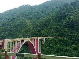
The Darjeeling hill area is formed of comparatively recent rock structure that has a direct bearing on landslides. Heavy monsoon precipitation contributes to the landslides. Soils of Darjeeling hill areas are extremely varied, depending on elevation, degree of slope, vegetative cover and geolithology.
The Himalayas serve as the source of natural resources for the population residing in the hills as well as in the plains. As human population expands in the hills, forests are being depleted for the extension of agricultural lands, introduction of new settlements, roadways, etc. The growing changes coming in the wake of urbanisation and industrialisation leave deep impressions on the hill ecosystem.
The economy of Darjeeling hill area depends on tea production, horticulture, agriculture, forestry and tourism. The major portions of the forests are today found at elevations of 2000 meters and above. The area in between 1000–2000 meters is cleared either for tea plantation or cultivation. About 30 percent of the forest covers found in the lower hills are deciduous. Evergreen forest constitutes only about 6 percent of the total forest coverage. Shorea robusta remains the most prominent species of tropical moist deciduous forest along with heavy undergrowth.
Teesta, Rangeet, Mechi, Balason, Mahananda, Lish, Gish, Chel, Ramman, Murti and Jaldhaka are the important rivers of the district.
Climate
| Climate data for Darjeeling | |||||||||||||
|---|---|---|---|---|---|---|---|---|---|---|---|---|---|
| Month | Jan | Feb | Mar | Apr | May | Jun | Jul | Aug | Sep | Oct | Nov | Dec | Year |
| Record high °C (°F) | 16 (61) |
17 (63) |
23 (73) |
24 (75) |
25 (77) |
24 (75) |
25 (77) |
25 (77) |
25 (77) |
23 (73) |
19 (66) |
17 (63) |
25 (77) |
| Average high °C (°F) | 8 (46) |
9 (48) |
14 (57) |
17 (63) |
18 (64) |
18 (64) |
19 (66) |
18 (64) |
18 (64) |
16 (61) |
12 (54) |
9 (48) |
14.7 (58.3) |
| Average low °C (°F) | 2 (36) |
2 (36) |
6 (43) |
9 (48) |
12 (54) |
13 (55) |
14 (57) |
14 (57) |
13 (55) |
10 (50) |
6 (43) |
3 (37) |
8.7 (47.6) |
| Record low °C (°F) | −3 (27) |
−2 (28) |
−1 (30) |
1 (34) |
6 (43) |
8 (46) |
9 (48) |
11 (52) |
10 (50) |
4 (39) |
2 (36) |
−1 (30) |
−3 (27) |
| Average precipitation mm (inches) | 13 (0.51) |
28 (1.1) |
43 (1.69) |
104 (4.09) |
216 (8.5) |
589 (23.19) |
798 (31.42) |
638 (25.12) |
447 (17.6) |
130 (5.12) |
23 (0.91) |
8 (0.31) |
3,037 (119.57) |
| Source: http://www.bbc.co.uk/weather/world/city_guides/results.shtml?tt=TT004930 | |||||||||||||
Divisions
Sub-divisions
Darjeeling District comprises four sub-divisions:
Assembly constituencies
The district was previously divided into five assembly constituencies.[4] As per order of the Delimitation Commission in respect of the delimitation of constituencies in West Bengal, the district has been divided into six assembly constituencies:[5]
- Kalimpong (assembly constituency no. 22),
- Darjeeling (assembly constituency no. 23),
- Kurseong (assembly constituency no. 24),
- Matigara-Naxalbari (SC) (assembly constituency no. 25),
- Siliguri (assembly constituency no. 26) and
- Phansidewa (ST) (assembly constituency no. 27).
Phansidewa constituency will continue to be reserved for Scheduled Tribes (ST) candidates. Matigara-Naxalbari constituency will be reserved for Scheduled Castes (SC) candidates. Along with one assembly constituency from North Dinajpur district, the six assembly constituencies of this district will form the Darjeeling Lok Sabha constituency.
Demographics
According to the 2011 census Darjeeling district has a population of 1,846,823,[1] roughly equal to the nation of Kosovo.[6] This gives it a ranking of 257th in India (out of a total of 640).[1] The district has a population density of 586 inhabitants per square kilometre (1,520/sq mi).[1] Its population growth rate over the decade 2001-2011 was 14.77%.[1] Darjeeling has a sex ratio of 970 females for every 1000 males,[1] and a literacy rate of 79.56%.[1][7]
In 2001, the population of the district was 1,609,172. The rural population was 1,088,740 and urban population was 520,432. Total males were 830,644 and females were 778,528. The density of population was 511 per km2. The decennial population growth rate (1991–2001) was 23.79%.[8]
The original inhabitants of the Darjeeling Hills were the Lepchas or Rongpa (the ravine folks) as they prefer themselves to be known as. They are decidedly Mongolian in physical features. The Limbus are another ancient inhabitants of this district. The greater bulk of the people in the hills today are the Gorkhas. They are industrious and enterprising as a race and speak Nepali and other dialects. Among the population are the Sherpas. They are well known for their contributions to mountaineering. Also much in evidence in the hills are the Denzongpas (Bhutias). There is also a sizeable population of Tibetans who arrived from Tibet since the 1950s. In the plains, one will find several communities like the Gorkhas, the adivasi people originally from Chotanagpur and Santhal Parganas, and a greater bulk of Bengali people.
Languages
The official language of all of West Bengal is Bengali, and Nepali is also recognised as official language in Darjeeling and Kurseon sub-divisions of the district of Darjeeling (but not the rest of the district).[9] The major languages spoken in Darjeeling district are Nepali (which is spoken by more than 60% of the population in Darjeeling Hill subdivision and 15% in Kalimpong and Kurseon subdivision), Bengali and Hindi are predominant in Terai region or Plain Siliguri subdivision. Other languages spoken are Bantawa, Bijori,[10] Bodo, Chamling, Dzongkha, Gurung, Kamta, Khaling, Kisan, Lepcha, Lhomi, Limbu, Sherpa, Sikkimese and Tamang.[11]
Flora and fauna
In 1986, Darjeeling district became home to Neora Valley National Park, which has an area of 88 km2 (34.0 sq mi).[12] It is also home to Singalila National Park, which was set up in 1986 as a wildlife sanctuary and converted to a national park in 1992. It has an area of 79 km2 (30.5 sq mi).[12]
Darjeeling district has three wildlife sanctuaries: Jorepokhri, Mahananda, and Senchal.[12]
See also
References
- 1 2 3 4 5 6 7 "District Census Handbook, Darjiling" (PDF). Directorate of Census Operations, West Bengal. 2011. Retrieved 29 September 2015.
- ↑ "Gorkhaland State a distinct possibility". The Hindu. Chennai, India. 15 May 2004.
- ↑ "Gorkha Territorial Administration members sworn in; Shinde, Mamata assure support". The Times of India. 5 August 2012. Retrieved 5 August 2012.
- ↑ "General election to the Legislative Assembly, 2001 – List of Parliamentary and Assembly Constituencies" (PDF). West Bengal. Election Commission of India. Retrieved 16 November 2008.
- ↑ "Press Note, Delimitation Commission" (PDF). Assembly Constituencies in West Bengal. Delimitation Commission. Retrieved 16 November 2008.
- ↑ US Directorate of Intelligence. "Country Comparison:Population". Retrieved 1 October 2011.
Kosovo 1,825,632 July 2011 est.
- ↑ "Census of India : Provisional Population Totals Paper 1 of 2011 : West Bengal". Censusindia.gov.in. Retrieved 13 June 2012.
- ↑ Archived 5 March 2010 at the Wayback Machine.
- ↑ "Report of the Commissioner for Linguistic Minorities in India: 50th report (delivered to the Lokh Sabha in 2014)" (PDF). National Commissioner for Linguistic Minorities, Ministry of Minority Affairs, Government of India. p. 95. Retrieved 13 July 2015.
- ↑ M. Paul Lewis, ed. (2009). "Bijori: A language of India". Ethnologue: Languages of the World (16th ed.). Dallas, Texas: SIL International. Retrieved 30 September 2011.
- ↑ "India". Ethnologue. Retrieved 1 August 2016.
- 1 2 3 Indian Ministry of Forests and Environment. "Protected areas: Sikkim". Retrieved 25 September 2011.
External links
| Wikimedia Commons has media related to Darjeeling district. |
- Darjeeling District official website
 Darjeeling (district) travel guide from Wikivoyage

Cities, towns and locations in Darjeeling District | |||||||||||||||
|---|---|---|---|---|---|---|---|---|---|---|---|---|---|---|---|
| Cities, municipal and census towns |
| ||||||||||||||
| Locations other than cities and towns | |||||||||||||||
| See also |
| ||||||||||||||
Coordinates: 27°02′N 88°10′E / 27.03°N 88.16°E