Kharagpur
| Kharagpur খড়্গপুর | |
|---|---|
| Urban Agglomeration | |
|
| |
| Nickname(s): KGP,The Mini India | |
 Kharagpur | |
| Coordinates: 22°19′49″N 87°19′25″E / 22.330239°N 87.323653°ECoordinates: 22°19′49″N 87°19′25″E / 22.330239°N 87.323653°E | |
| Country |
|
| State | West Bengal |
| District | Paschim Medinipur |
| Named for | Railway settlement, India's first IIT,Largest city in West Midnapur district |
| Government | |
| • Type | Municipal Corporation |
| • Body | KMC |
| • MLA | Dilip Kumar Ghosh (BJP) |
| • Mayor | Pradip Sarkar(TMC) |
| Area | |
| • Total | 321 km2 (124 sq mi) |
| Elevation | 61 m (200 ft) |
| Population (2011)[1] | |
| • Total | 207,604[2] |
| • Rank | 91 in india |
| Demonym(s) | Kharagpurian, |
| Languages | |
| • Official | Bengali & English |
| Time zone | IST (UTC+5:30) |
| PIN | 721301 / 721304 |
| Telephone code | 03222 |
| Vehicle registration | WB-34-xxxx |
| Lok Sabha constituency | Medinipur |
| Vidhan Sabha constituency | Kharagpur Sadar |
| Website |
paschimmedinipur |
Kharagpur ![]() pronunciation (Bengali: খড়্গপুর) is an important industrial city in Paschim Medinipur district of West Bengal, India. It is multi-cultural and cosmopolitan city. It is the most populated city of Paschim Medinipur district.[3] The first Indian Institutes of Technology (IIT), a group of Institutes of National Importance, was founded in Kharagpur as early as in May 1950.[4] It is 116 km from Kolkata and forms an important station on Howrah-Mumbai, Howrah-Chennai road and railway route. This city also has one of the largest railway workshops in India, and the third longest railway platform in the world (1072.5 m).[5] Kharagpur has an Air Force base in Kalaikunda, and another in Salua. There have been plans by the IAF to allow civil flights in Kalaikunda.[6]
pronunciation (Bengali: খড়্গপুর) is an important industrial city in Paschim Medinipur district of West Bengal, India. It is multi-cultural and cosmopolitan city. It is the most populated city of Paschim Medinipur district.[3] The first Indian Institutes of Technology (IIT), a group of Institutes of National Importance, was founded in Kharagpur as early as in May 1950.[4] It is 116 km from Kolkata and forms an important station on Howrah-Mumbai, Howrah-Chennai road and railway route. This city also has one of the largest railway workshops in India, and the third longest railway platform in the world (1072.5 m).[5] Kharagpur has an Air Force base in Kalaikunda, and another in Salua. There have been plans by the IAF to allow civil flights in Kalaikunda.[6]
History
Kharagpur received its name from the twelfth king of Mallabhum, Kharga Malla, when he conquered it.[7][8] Kharagpur was a part of the Hijli Kingdom and ruled by Hindu Oriya rulers as a feudatory under Gajapati Kings of Orissa. Historians claim that in the 16th century, Kharagpur was still a small village surrounded by dense forests. The village was on high rocky barren land. The only inhabited settlement near Kharagpur was Hijli. Hijli was a small island village on the banks of the Rasulpur River, in the delta of Bay of Bengal. It developed into a port town in 1687. Hijli was also a province and it existed until 1886. It covered parts of Bengal and Orissa. It had important towns like Tamluk, Panskura, and Debra, along with the Kelghai and Haldi rivers on the north, south, and east sides bounded by Bay of Bengal and Kharagpur, Keshiary, Dantan, and Jaleswar on the west.
Hijli was ruled by Taj Khan who was the disciple of Guru Peer Mackdram Sha Chisti. It was also ruled by the Kushan, Gupta, and Pal dynasties, and by the Mughals. It is said that Hijli had excellent business and trade centers with judiciary, prison, and administrative offices during the reign of Hindu Kings and during the Mughal Raj. The capital of Hijli was in Bahiri up to 1628 and was shifted to Hijli afterwards. Hijli Province was at its peak in 1754 and was highly prosperous during this period.
Captain Nicolson was the first English colonialist to invade Hijli and captured the port. In 1687 Job Charnock with soldiers and warships captured Hijli, defeating Hindu and Mughal defenders. After the war with the Mughals, a treaty was signed between Job Charnock and the Mughal Emperor. The loss suffered by Job Charnock forced him to leave Hijli and to proceed towards Uluberia, while the Mughal Emperor continued to rule the province. From there, they finally settled at Sutanuti in Kolkata to establish their business in Eastern India. This was the start of the East India Company in India. Hijli as we know it today is only a small part of the Hijli Province, and was created for establishing administrative offices by the British in the 19th century. It is curious that almost the entire Kharagpur division of today has boundaries identical to Hijli Province.
In the 18th century Khejuri, another port town was set up on the banks of the Koukhali River in the delta region . It was established by the British primarily for carrying out trade with European countries. Khejuri was also an island . In the devastating cyclone of 1864, both ports were destroyed. The islands have since merged with the mainland.
Railways in Kharagpur
The first railway establishment at Kharagpur started with the commissioning of the rail link between Cuttack – Balasore – Kharagpur and from Sini to Kolaghat via Kharagpur. Kharagpur as a junction station was established in Railway map in December 1898. The public mood and the reaction of society on introduction of rail transport in this region has been nicely depicted by the famous Bengali Novelist Dr Ramapada Choudhury (who was born and raised in Kharagpur) in his novel Prothom Prohor. It is said that the people were initially afraid to travel by train for fear of the bridge collapsing, and for fear of getting outcaste or Dalit status, since there were no separate seating arrangement for different castes and religions. However, things changed due to famines in the early 20th century. The railway company came forward and offered jobs to the local unemployed men, gave them free ride by train, and even offered a blanket for travelling by train. This promotional scheme broke the taboos and made rail transport acceptable to the society.
Midnapur's District Headquarters was connected to the bank of the Kosai River in February 1900. Construction of the bridge over Kosai completed in June 1901. The rail line from Howrah to Kolaghat up to the Eastern bank and from Kharagpur up to Western bank of Rupnarayan River was completed in 1899. However, trains between Howrah and Kharagpur was possible only in April 1900 after the bridge over Rupnarayan river was completed.
Howrah – Amta light Railway (2 ft gauge - 610 mm ) line was completed in 1898 and was operated by M/s Martin & Co. of Calcutta. This link remained operative till 1971. After closure of the light railways, the demand for a broad gauge line between Howrah and Amta gained momentum. The project was completed in four phases. In the first phase, the line between Santragachi and Domjur was completed in 1984. In the 2nd phase under Project Unigauge it got extended up to Bargachia in 1985. Extension up to Munsirhat (Mahendralal Nagar station) was completed in 2000, and the final lap up to Amta got completed in December 2004.
The need for a rail link between Panskura and Tamluk was conceived at the beginning of 20th century, almost at the same time the rail link between Howrah and Kharagpur was opened. The railway company received offers for construction from two Agencies, M/S Martin & Company and M/s Babu Nibaran Chandra Dutta. The former against guaranteed return of 3.5% while the latter without any guarantee. Although the offer of the latter was lucrative, the dilemma of whether to offer the work of construction to a native or not forced the project to be abandoned. After Independence, the requirement of rail link connecting Panskura and Durgachak came up primarily for the purpose of constructing Haldia Port. The rail link between Panskura – Durgachak via Tamluk completed in 1968, which was later extended to Haldia in 1975. Extension of rail link to Digha from Tamluk was sanctioned in 1984; it took 20 years to complete, in two phases. The first phase linked Tamluk and Contai in November 2003, and the tourist destination Digha was connected to Howrah in December 2004.
Geographical location of Kharagpur and its rail links with the rest of the country favored construction of a centralized workshop with facilities to carry out major repairs of all broad gauge stock. The work was sanctioned in 1900; construction of the workshop was completed in 1904.
Geography
Kharagpur, the fourth largest city of West Bengal in area after Kolkata, Durgapur and Asansol and fifth most populated city of West Bengal after Kolkata, Asansol, Siliguri, Durgapur - located at 22°19′49″N 87°19′25″E / 22.330239°N 87.323653°E, covering an area of about 127 km2 located in south-western Midnapore.[9] It has an average elevation of 29 metres (95 ft). This sub-division town is formed with Dalma Pahar and alluvial tract of Midnapore. It is intersected by numerous waterways, the important rivers being Subarnarekha, Keleghai and Kangsabati.
Urban structure
Nimpura is a place for housing of thousands of Railway Employees. There is a long winding road from Nimpura to Hijli which goes through Tangrahut (Arambati), Talbagicha and another one from Kalaikunda to Gopali through Hiradihi,Talbagicha. The south of Kharagpur is a planned area belonging to the Indian Railways which was established by Britishers as residential area. Nearby is the Kharagpur Municipality and the fire station. Kharagpur Railway Colony is the biggest railway settlement in India having about 13,000 quarters. There are several railway residential areas namely Chhotta Ayma, Bara Ayma, Old Settlement, New Settlement, Mathurakati, Nimpura, South Side, Traffic etc. The BNR ground is a very large playground which can be developed and properly maintained. Outside railway settlement popular areas are Bhawanipur, Subhaspally, Kharida, Malancha, Jhapatapur, Prem Bazaar, amongst others. Important market place has developed around Gole Bazaar which is one of the favourite and reliable shopping destination for locals. Other markets like-Gate Bazar,Inda Bazar,Puratan Bazar,Janata Market,Kaushallya,DVC market,IIT Tech market are also renownded in Kharagpur town.Twin is witnessing growth around Chowringhee, Inda area's where new construction has taken place. Biz Bazaar operated by Future Group has opened its store in Kharagpur.
| Kharagpur | ||||||||||||||||||||||||||||||||||||||||||||||||||||||||||||
|---|---|---|---|---|---|---|---|---|---|---|---|---|---|---|---|---|---|---|---|---|---|---|---|---|---|---|---|---|---|---|---|---|---|---|---|---|---|---|---|---|---|---|---|---|---|---|---|---|---|---|---|---|---|---|---|---|---|---|---|---|
| Climate chart (explanation) | ||||||||||||||||||||||||||||||||||||||||||||||||||||||||||||
| ||||||||||||||||||||||||||||||||||||||||||||||||||||||||||||
| ||||||||||||||||||||||||||||||||||||||||||||||||||||||||||||
Climate
Kharagpur has a tropical wet and dry climate. Summers start in March and are hot and humid, with average temperatures close to 30 °C (86 °F). They are followed by the monsoon season that sees about 1140 mm (45 inches) of rain. Winters are brief but chilly, lasting from December to mid February, with average temperatures around 22 °C (72 °F). Total annual rainfall is around 1400mm (55 in).
Demographics
In the 2011 census, Kharagpur Urban Agglomeration had a population of 293,719[2] out of which 150,487 were males and 143,232 were females. . The 0–6 years population was 25,130. Effective literacy rate for the 7+ population was 85.61.[10]
As of 2001 India census,[11] Kharagpur had a population of 207,984 (municipality area) and 88,339 (railway settlement area), the fourth largest in West Bengal. Males constitute 52% of the population and females 48%. Kharagpur has an average literacy rate of 64%, higher than the national average of 59.5%: male literacy is 75%, and female literacy is 52%. In Kharagpur, 10% of the population is under 6 years of age. Kharagpur acquires its unique place in India as a town of mixed ethnicity and linguistic diversity.
Kharagpur (Town) police station has jurisdiction over Kharagpur municipality.[12][13]
Kharagpur (Local) police station has jurisdiction over Kharagpur I and Kharagpur II CD Blocks.[12][13]
Civic administration and utility services
Kharagpur Municipality looks after civic affairs in the city. There is a proposal to upgrade it to a Municipal Corporation after including railway area under its jurisdiction. As of now responsibility of civic amenities in railway area lies with the Divisional Railway Manager, Kharagpur Division who is also the head of railway establishment in Kharagpur.
State-owned Bharat Sanchar Nigam Limited, or BSNL, as well as private enterprises, among them Vodafone, Bharti Airtel, Reliance, Idea Cellular, Aircel, and Tata DoCoMo, are the leading telephone, cell phone and internet service providers in the city.[14][15]
Transport
Railways
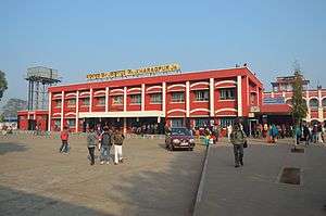
Kharagpur Railway Junction is the busiest junction station in South Eastern Railway Zone after Howrah. Hence, it is often termed as Gateway to South Eastern Railway. Kharagpur has the third longest platform of the world, Everyday approximately 275 trains pass through kharagpur which includes freight. It has also been identified as one of Dedicated Freight Corridors (DFC) - on the East-West (Howrah-Mumbai), on the East-Coast (Kharagpur-Vijayawada).
Roadways
Kharagpur also well connected with various places by road.
NH-6(Bombay-Kolkata Road) passes through this city.
Education
School
- St.Joseph's School
- Christopher day School
- Sacred Heart School
- St. Agnes School
- D.A.V Model School IIT Kharagpur.
- Railway Mixed Higher Secondary School (English Medium), Kharagpur
- Griffins International School, NH-60, Mouza P.O. Khatranga, Khatranga, West Bengal
- Hijli High School.
- Kendriya Vidyalaya IIT Kharagpur
- Kendriya Vidyalaya Jhapatapur
- Kendriya Vidyalaya Kalaikunda
- Kendriya Vidyalaya Air Force Station Salua
- South Eastern Railway Boys Higher Secondary School (now South Eastern Railway Mixed SR High School)
- Inda Krishnalal Shiksha Niketan,
- Inda Girls,Kharagpur
- Silver Jubilee High School,
- South Development Boys & Girls High School
- Nimpura Arya Vidyapeeth,
- Atulmani High School
- Janakalyan High School
- Talbagicha High School.
- Hitkarini Higher Secondary School.
College
- Kharagpur College.
- Hijli College.Higher Secondary
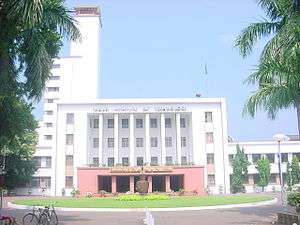
IIT Kharagpur
The Indian Institute of Technology Kharagpur (or IIT Kharagpur) is a public engineering, management, medical and law institution established by the government of India in 1951. The first of the IITs to be established, it is recognized as an Institute of National Importance by the government of India.
The institute was established to train scientists and engineers after India attained independence in 1947. It shares its organisational structure and undergraduate admission process with sister IITs. The students and alumni of IIT Kharagpur are informally referred to as KGPians. Among all IITs, IIT Kharagpur has the largest campus (2,100 acres),[16] the most departments, and the highest student enrolment.
Healthcare
The need for a centralized Hospital at Khargpur was also felt in late 19th century and the Hospital with complete medical facilities was established in 1897. Dr Arthur Martin Leake, Victorian Cross winner was appointed as Chief Medical Officer of Kharagpur Hospital in 1904. However the town needs good private hospitals and advanced medication facilities as in current scenario its citizens have to depend on Kolkata for treatment, which is at a distance of 116 km. The two prominent hospitals at present are General Hospital and Railway Hospital.
Today Railway Main Hospital and Kharagpur Sub-divisional Hospital (Chandmari Hospital) are main public sector hospitals in Kharagpur. A number of private clinics and nursing homes also operate.
Culture
Apart from Bengali,Telugu,Hindi are widely spoken languages.
Places of worship include a "Durga Mandir" at Gole Bazar,Sitala Mandir at Puratan Bazar, Jama Masjid at Gole Bazar, "Kanaka Durga Temple near Nimpura,"Jagannath Mandir" near Gate Bazar,"Gurudwara" at Subhaspally and at Nimpura, Jalaram Temple at Jhapatapur and several religious structures.The most famous festivals here are Durga Puja, Eid-ul-Fitr, Ganesh Puja, Eid-ul-Zoha, Saraswati Puja, Shab-e-Barat, Kali Puja, Muharram, Ammavaari Puja, Navratri, Barah wafat and others. The biggest festival of all is the Dussehra or Ravan Pora.
Kharagpur has a Book Fair ("Kharagpur-er Boimela" in Bengali) which started in 2000 and happens every January. A Flower Fair ("Ful Mela" in Bengali) is also organized every year.
Tourism
Kosai River forms an important picnic spot.
Industrial setup
Kharagpur has one of the largest industrial setup in the West Bengal. Many large industrial setups are located in and around Kharagpur due to its proximity to Kolkata, good rail and road connectivity via NH-6, availability of labour, and raw materials. Important establishments like Tata Metaliks, Tata Bearings, Siemens, Kharagpur Metal, ISD Cement, Godrej, Telcon, Century Extrusions, Humboldt, Rashmi Metaliks, BRG Group,Bengal Energy,Ramco Cement have set up their plants in and around Kharagpur. Many small iron rolling mills and rice mills dot the town. There is also an flourishing real estate market.
References
- ↑ "West Bengal (India): Districts, Cities, Towns and Outgrowth Wards - Population Statistics in Maps and Charts".
- 1 2 "Kharagpur City demography". Census 2011. Retrieved 27 May 2015.
- ↑ "Cities having population 1 lakh and above, Census 2011" (PDF). Census of India. Government of India, Ministry of Home Affairs. Retrieved 23 December 2013.
- ↑ "Brief history of the Institute and context of its formation". Indian Institute of Technology, Kharagpur. Indian Institute of Technology, Kharagpur. Retrieved 23 December 2013.
- ↑ Singh, Mahendra (1 October 2013). "Gorakhpur set to have longest railway platform in world". Times of India. Retrieved 23 December 2013.
- ↑ see also http://articles.timesofindia.indiatimes.com/2011-09-30/kolkata/30229574_1_iaf-aircraft-forest-land-cultivable-land
- ↑ Dasgupta, Gautam Kumar; Biswas, Samira,; Mallik, Rabiranjan, (2009), Heritage Tourism: An Anthropological Journey to Bishnupur, New Delhi: Mittal, p. 32, ISBN 8183242944
- ↑ Mallik, Abhaya Pada (1921). History of Bishnupur-Raj: An Ancient Kingdom of West Bengal (the University of Michigan ed.). Calcutta. p. 14. Retrieved 11 March 2016.
- ↑ "Maps, Weather, and Airports for Kharagpur, India".
- ↑ "Urban Agglomerations/Cities having population 1 lakh and above" (PDF). Provisional Population Totals, Census of India 2011. Retrieved 21 October 2011.
- ↑ "Census of India 2001: Data from the 2001 Census, including cities, villages and towns (Provisional)". Census Commission of India. Archived from the original on 16 June 2004. Retrieved 1 November 2008.
- 1 2 "District Statistical Handbook 2014 Paschim Medinipur". Tables 2.1, 2.2. Department of Statistics and Programme Implementation, Government of West Bengal. Retrieved 14 October 2016.
- 1 2 "District at a Glance". Paschim Medinipur District Police. Retrieved 27 October 2016.
- ↑ "Annual report 2010–11" (PDF). Telecom Regulatory Authority of India. Retrieved 13 June 2012.
- ↑ "The Indian telecom services performance indicators October — December 2011" (PDF). Telecom Regulatory Authority of India. 13 April 2012. pp. 122–126. Retrieved 25 June 2012.
- ↑ "Institute History". IIT Kharagpur. Retrieved 2 May 2008.
External links
| Wikimedia Commons has media related to Kharagpur. |
-
 Kharagpur travel guide from Wikivoyage
 - Indian Institute of Technology, Kharagpur
- IIT
- [ KGP Railway]
- Kharagpur’s diaspora reunited
- Kharagpur Official Google+ Page
- Apprise Technologies, an IT company located in Kharagpur
Cities, towns and locations in Paschim Medinipur District | |||||||||||||||
|---|---|---|---|---|---|---|---|---|---|---|---|---|---|---|---|
| Cities, municipal and census towns |
| ||||||||||||||
| Locations other than cities and towns |
| ||||||||||||||
| Related topics |
| ||||||||||||||