Medina County, Ohio
| Medina County, Ohio | ||
|---|---|---|
|
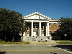
Medina County Courthouse | ||
| ||
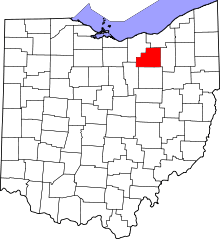 Location in the U.S. state of Ohio | ||
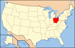 Ohio's location in the U.S. | ||
| Founded | 1812 | |
| Named for | Medina[1] | |
| Seat | Medina | |
| Largest city | Brunswick | |
| Area | ||
| • Total | 423 sq mi (1,096 km2) | |
| • Land | 421 sq mi (1,090 km2) | |
| • Water | 1.7 sq mi (4 km2), 0.4% | |
| Population | ||
| • (2010) | 172,332 | |
| • Density | 409/sq mi (158/km²) | |
| Congressional districts | 7th, 16th | |
| Time zone | Eastern: UTC-5/-4 | |
| Website |
www | |

Medina County (pronounced /məˈdaɪnə/, commonly misprounced as /məˈdiːnə/[2]) is a county in the U.S. state of Ohio. As of the 2010 census, the population was 172,332.[3] Its county seat is Medina.[4] The county was created in 1812 and later organized in 1818.[5] It is named for Medina, though the "I" in it is pronounced as in "dine."[6]
Medina County is part of the Cleveland-Elyria, OH Metropolitan Statistical Area, although some sections have closer ties to the Akron area.
History
After the discovery of the New World, the land that became Medina County was originally part of the French colony of Canada (New France), which was ceded in 1763 to Great Britain and renamed Province of Quebec. In the late 18th century the land became part of the Connecticut Western Reserve in the Northwest Territory, then was purchased by the Connecticut Land Company in 1795. Parts of Medina County and neighbouring Lorain became home to the The Black River Colony founded in 1852, a religious community centered on the pious lifestyle of the German Baptist Brethren.
Geography
According to the U.S. Census Bureau, the county has a total area of 423 square miles (1,100 km2), of which 421 square miles (1,090 km2) is land and 1.7 square miles (4.4 km2) (0.4%) is water.[7]
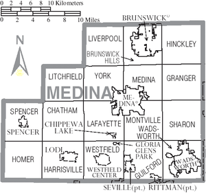
Adjacent counties
- Cuyahoga County (northeast)
- Summit County (east)
- Wayne County (south)
- Ashland County (southwest)
- Lorain County (northwest)
Demographics
| Historical population | |||
|---|---|---|---|
| Census | Pop. | %± | |
| 1820 | 3,082 | — | |
| 1830 | 7,560 | 145.3% | |
| 1840 | 18,352 | 142.8% | |
| 1850 | 24,441 | 33.2% | |
| 1860 | 22,517 | −7.9% | |
| 1870 | 20,092 | −10.8% | |
| 1880 | 21,453 | 6.8% | |
| 1890 | 21,742 | 1.3% | |
| 1900 | 21,958 | 1.0% | |
| 1910 | 23,598 | 7.5% | |
| 1920 | 26,067 | 10.5% | |
| 1930 | 29,677 | 13.8% | |
| 1940 | 33,034 | 11.3% | |
| 1950 | 40,417 | 22.3% | |
| 1960 | 65,315 | 61.6% | |
| 1970 | 82,717 | 26.6% | |
| 1980 | 113,150 | 36.8% | |
| 1990 | 122,354 | 8.1% | |
| 2000 | 151,095 | 23.5% | |
| 2010 | 172,332 | 14.1% | |
| Est. 2015 | 176,395 | [8] | 2.4% |
| U.S. Decennial Census[9] 1790-1960[10] 1900-1990[11] 1990-2000[12] 2010-2015[3] | |||
2000 census
As of the census[13] of 2010, there were 172,332 people, 54,542 households, and 42,215 families residing in the county. The population density was 358 people per square mile (138/km²). There were 56,793 housing units at an average density of 135 per square mile (52/km²). The racial makeup of the county was 97.26% White, 0.88% Black or African American, 0.15% Native American, 0.64% Asian, 0.02% Pacific Islander, 0.25% from other races, and 0.80% from two or more races. 0.93% of the population were Hispanic or Latino of any race. 26.8% were of German, 11.5% Irish, 8.6% Italian, 8.4% English, 8.4% Polish and 7.8% American ancestry according to Census 2000. 95.3% spoke English, 1.2% Spanish and 1.0% German as their first language.
There were 54,542 households, of which 37.70% had children under the age of 18 living with them, 66.50% were married couples living together, 7.80% had a female householder with no husband present, and 22.60% were non-families. 18.90% of all households were made up of individuals and 6.90% had someone living alone who was 65 years of age or older. The average household size was 2.74 and the average family size was 3.15.
In the county, the population was spread out with 27.50% under the age of 18, 7.00% from 18 to 24, 30.60% from 25 to 44, 24.40% from 45 to 64, and 10.50% who were 65 years of age or older. The median age was 37 years. For every 100 females there were 97.10 males. For every 100 females age 18 and over, there were 94.90 males.
The median income for a household in the county was $55,811, and the median income for a family was $62,489. Males had a median income of $44,600 versus $27,513 for females. The per capita income for the county was $24,251. About 3.50% of families and 4.60% of the population were below the poverty line, including 5.90% of those under age 18 and 4.80% of those age 65 or over.
2010 census
As of the 2010 United States Census, there were 172,332 people, 65,143 households, and 48,214 families residing in the county.[14] The population density was 409.0 inhabitants per square mile (157.9/km2). There were 69,181 housing units at an average density of 164.2 per square mile (63.4/km2).[15] The racial makeup of the county was 96.1% white, 1.2% black or African American, 1.0% Asian, 0.1% American Indian, 0.4% from other races, and 1.2% from two or more races. Those of Hispanic or Latino origin made up 1.6% of the population.[14] In terms of ancestry, 32.7% were German, 18.3% were Irish, 11.6% were English, 10.7% were Italian, 10.4% were Polish, and 7.4% were American.[16]
Of the 65,143 households, 35.3% had children under the age of 18 living with them, 61.5% were married couples living together, 8.7% had a female householder with no husband present, 26.0% were non-families, and 21.6% of all households were made up of individuals. The average household size was 2.63 and the average family size was 3.07. The median age was 40.4 years.[14]
The median income for a household in the county was $66,193 and the median income for a family was $76,699. Males had a median income of $56,523 versus $38,163 for females. The per capita income for the county was $29,986. About 4.4% of families and 6.3% of the population were below the poverty line, including 8.6% of those under age 18 and 5.6% of those age 65 or over.[17]
Politics
| Year | Republican | Democrat |
|---|---|---|
| 2016 | 59.51% 53,811 | 34.93% 31,582 |
| 2012 | 55.45% 50,418 | 42.65% 38,785 |
| 2008 | 53.16% 48,189 | 45.14% 40,924 |
| 2004 | 56.78% 48,196 | 42.73% 36,272 |
| 2000 | 55.84% 37,349 | 39.82% 26,635 |
Communities
Cities
Villages
- Briarwood Beach
- Chippewa Lake
- Creston (part)
- Gloria Glens Park
- Lodi
- Seville
- Spencer
- Westfield Center
Townships
Unincorporated communities
- Abbeyville
- Beebetown
- Bennetts Corners
- Chatham
- Coddingville
- Crawford Corners
- Erhart
- Friendsville
- Granger
- Hinckley
- Homerville
- Lester
- Litchfield
- Mallet Creek
- Pawnee
- Remsen Corners
- River Styx
- Sharon Center
- Valley City
- Weymouth
- Windfall
Notable people
- Martin and Anna Bates, record holders for tallest married couple
- Connor Cook, quarterback for the Michigan State Spartans
- R. Sheldon Duecker, a retired Bishop of the United Methodist Church, born and raised in Westfield Township.
- Pete Rademacher, Olympic boxer
- Amos Root, developed innovative beekeeping techniques in the United States during the mid-19th century
- William G. Batchelder III Speaker of the Ohio House of Representatives
- Kyle Juszczyk, Baltimore Ravens player
- Jobie Hughes, one of the authors of the Lorien Legacies, was raised in Spencer, where he attended Black River High School
See also
References
- ↑ Gannett, Henry (1905). The Origin of Certain Place Names in the United States. U.S. Government Printing Office. p. 204.
- ↑ Cahsman, Pat. "Proper pronunciation please". Retrieved 31 October 2015.
- 1 2 "State & County QuickFacts". United States Census Bureau. Retrieved February 9, 2015.
- ↑ "Find a County". National Association of Counties. Archived from the original on May 31, 2011. Retrieved 2011-06-07.
- ↑ "Ohio: Individual County Chronologies". Ohio Atlas of Historical County Boundaries. The Newberry Library. 2007. Retrieved February 14, 2015.
- ↑ "Medina County data". Ohio State University Extension Data Center. Retrieved 2007-04-28.
- ↑ "2010 Census Gazetteer Files". United States Census Bureau. August 22, 2012. Retrieved February 9, 2015.
- ↑ "County Totals Dataset: Population, Population Change and Estimated Components of Population Change: April 1, 2010 to July 1, 2015". Retrieved July 2, 2016.
- ↑ "U.S. Decennial Census". United States Census Bureau. Archived from the original on May 11, 2015. Retrieved February 9, 2015.
- ↑ "Historical Census Browser". University of Virginia Library. Retrieved February 9, 2015.
- ↑ Forstall, Richard L., ed. (March 27, 1995). "Population of Counties by Decennial Census: 1900 to 1990". United States Census Bureau. Retrieved February 9, 2015.
- ↑ "Census 2000 PHC-T-4. Ranking Tables for Counties: 1990 and 2000" (PDF). United States Census Bureau. April 2, 2001. Retrieved February 9, 2015.
- ↑ "American FactFinder". United States Census Bureau. Retrieved 2015-06-27.
- 1 2 3 "DP-1 Profile of General Population and Housing Characteristics: 2010 Demographic Profile Data". United States Census Bureau. Retrieved 2015-12-27.
- ↑ "Population, Housing Units, Area, and Density: 2010 - County". United States Census Bureau. Retrieved 2015-12-27.
- ↑ "DP02 SELECTED SOCIAL CHARACTERISTICS IN THE UNITED STATES – 2006-2010 American Community Survey 5-Year Estimates". United States Census Bureau. Retrieved 2015-12-27.
- ↑ "DP03 SELECTED ECONOMIC CHARACTERISTICS – 2006-2010 American Community Survey 5-Year Estimates". United States Census Bureau. Retrieved 2015-12-27.
- ↑ "Dave Leip's Atlas of U.S. Presidential Elections". Retrieved 2016-03-26.
External links
| Wikimedia Commons has media related to Medina County, Ohio. |
- Medina County District Library's website
- Medina County Government's website
- Medina County Sheriff's Office
- Medina County News and Events
 |
Lorain County | Cuyahoga County | | |
| |
Summit County | |||
| ||||
| | ||||
| Ashland County | Wayne County |
Municipalities and communities of Medina County, Ohio, United States | ||
|---|---|---|
| Cities | | |
| Villages | ||
| Townships | ||
| Unincorporated communities | ||
| Footnotes | ‡This populated place also has portions in an adjacent county or counties | |
Coordinates: 41°07′N 81°54′W / 41.12°N 81.90°W