National Register of Historic Places listings in Coffee County, Tennessee
Location of Coffee County in Tennessee
This is a list of the National Register of Historic Places listings in Coffee County, Tennessee.
This is intended to be a complete list of the properties and districts on the National Register of Historic Places in Coffee County, Tennessee, United States. Latitude and longitude coordinates are provided for many National Register properties and districts; these locations may be seen together in a map.[1]
There are 11 properties and districts listed on the National Register in the county.
| Anderson – Bedford – Benton – Bledsoe – Blount – Bradley – Campbell – Cannon – Carroll – Carter – Cheatham – Chester – Claiborne – Clay – Cocke – Coffee – Crockett – Cumberland – Davidson – Decatur – DeKalb – Dickson – Dyer – Fayette – Fentress – Franklin – Gibson – Giles – Grainger – Greene – Grundy – Hamblen – Hamilton – Hancock – Hardeman – Hardin – Hawkins – Haywood – Henderson – Henry – Hickman – Houston – Humphreys – Jackson – Jefferson – Johnson – Knox – Lake – Lauderdale – Lawrence – Lewis – Lincoln – Loudon – Macon – Madison – Marion – Marshall – Maury – McMinn – McNairy – Meigs – Monroe – Montgomery – Moore – Morgan – Obion – Overton – Perry – Pickett – Polk – Putnam – Rhea – Roane – Robertson – Rutherford – Scott – Sequatchie – Sevier – Shelby – Smith – Stewart – Sullivan – Sumner – Tipton – Trousdale – Unicoi – Union – Van Buren – Warren – Washington – Wayne – Weakley – White – Williamson – Wilson |
- This National Park Service list is complete through NPS recent listings posted December 2, 2016.[2]
Current listings
| [3] | Name on the Register[4] | Image | Date listed[5] | Location | City or town | Description |
|---|---|---|---|---|---|---|
| 1 | Cascade Distillery Site | 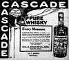 |
(#94000578) |
Western side of Cascade Dr., about 0.7 miles northwest of the junction with Riley Creek Rd. 35°25′14″N 86°14′21″W / 35.420556°N 86.239167°W |
Normandy | The original site of the George Dickel distillery, the current site of which lies just to the north |
| 2 | Coffee County Courthouse | 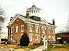 |
(#74001905) |
Public Sq. 35°28′59″N 86°05′20″W / 35.483056°N 86.088889°W |
Manchester | Built in 1871 |
| 3 | Crouch-Ramsey Family Farm | 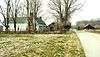 |
(#05000830) |
3016 Hickory Grove Rd. 35°32′41″N 85°57′28″W / 35.544722°N 85.957778°W |
Summitville | Tennessee Century Farm established by Thomas Cunningham in 1901; house and log barn date to the 19th century |
| 4 | Farrar Distillery | Upload image | (#84003472) |
Noah Fork Rd. 35°34′50″N 86°10′18″W / 35.580556°N 86.171667°W |
Noah | |
| 5 | L.D. Hickerson House | 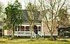 |
(#89001395) |
215 N. Washington St. 35°21′56″N 86°12′36″W / 35.365556°N 86.21°W |
Tullahoma | Built in 1895 by Lytle David Hickerson |
| 6 | John H. Leming House |  |
(#11000092) |
414 E. Main St. 35°28′56″N 86°04′59″W / 35.482222°N 86.083056°W |
Manchester | Built by John Leming in 1899 |
| 7 | Manchester Cumberland Presbyterian Church | Upload image | (#92000781) |
Junction of Church and W. High Sts. 35°29′04″N 86°05′26″W / 35.484444°N 86.090556°W |
Manchester | |
| 8 | North Atlantic Street Historic District | 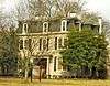 |
(#88001052) |
200-500 blocks of N. Atlantic St. 35°21′58″N 86°12′43″W / 35.366111°N 86.211944°W |
Tullahoma | Victorian houses built in the late 19th century for merchants and railroad managers |
| 9 | North Washington Street Historic District |  |
(#89001396) |
603-611 N. Washington St. 35°22′12″N 86°12′50″W / 35.37°N 86.213889°W |
Tullahoma | 1920s-era cottages built for railroad workers |
| 10 | Old Stone Fort | 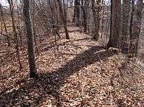 |
(#73001757) |
West of Manchester 35°28′59″N 86°06′29″W / 35.483056°N 86.108056°W |
Manchester | |
| 11 | Wilkinson-Keele House |  |
(#06001040) |
313 S. Ramsey St. 35°28′55″N 86°05′03″W / 35.481944°N 86.084167°W |
Manchester | Built in 1888 |
See also
| Wikimedia Commons has media related to National Register of Historic Places in Coffee County, Tennessee. |
- List of National Historic Landmarks in Tennessee
- National Register of Historic Places listings in Tennessee
References
- ↑ The latitude and longitude information provided in this table was derived originally from the National Register Information System, which has been found to be fairly accurate for about 99% of listings. For about 1% of NRIS original coordinates, experience has shown that one or both coordinates are typos or otherwise extremely far off; some corrections may have been made. A more subtle problem causes many locations to be off by up to 150 yards, depending on location in the country: most NRIS coordinates were derived from tracing out latitude and longitudes off of USGS topographical quadrant maps created under the North American Datum of 1927, which differs from the current, highly accurate WGS84 GPS system used by most on-line maps. Chicago is about right, but NRIS longitudes in Washington are higher by about 4.5 seconds, and are lower by about 2.0 seconds in Maine. Latitudes differ by about 1.0 second in Florida. Some locations in this table may have been corrected to current GPS standards.
- ↑ "National Register of Historic Places: Weekly List Actions". National Park Service, United States Department of the Interior. Retrieved on December 2, 2016.
- ↑ Numbers represent an ordering by significant words. Various colorings, defined here, differentiate National Historic Landmarks and historic districts from other NRHP buildings, structures, sites or objects.
- ↑ National Park Service (2008-04-24). "National Register Information System". National Register of Historic Places. National Park Service.
- ↑ The eight-digit number below each date is the number assigned to each location in the National Register Information System database, which can be viewed by clicking the number.
| Topics | |
|---|---|
| Lists by states |
|
| Lists by insular areas | |
| Lists by associated states | |
| Other areas | |
| |
Municipalities and communities of Coffee County, Tennessee, United States | ||
|---|---|---|
| Cities | ||
| CDPs | ||
| Unincorporated communities | ||
| Footnotes | ‡This populated place also has portions in an adjacent county or counties | |
This article is issued from Wikipedia - version of the 6/7/2016. The text is available under the Creative Commons Attribution/Share Alike but additional terms may apply for the media files.