| [3] |
Name on the Register[4] |
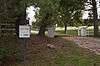
Image |
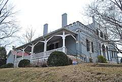
Date listed[5] |
Location |
City or town |
Description |
|---|
| 1 |
Jonathan Amis House |
Upload image |
000000001984-04-26-0000April 26, 1984
(#84003620) |
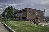
Covey Hollow Rd.
35°29′27″N 87°02′43″W / 35.490833°N 87.045278°W / 35.490833; -87.045278 (Jonathan Amis House) |
McCains |
|
| 2 |
Ashwood Rural Historic District |
Upload image |
000000001989-02-10-0000February 10, 1989
(#88003247) |
Spans U.S. Route 43 between Columbia and Mount Pleasant
35°34′24″N 87°08′18″W / 35.573333°N 87.138333°W / 35.573333; -87.138333 (Ashwood Rural Historic District) |
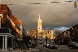
Columbia |
|
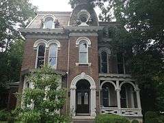
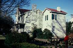
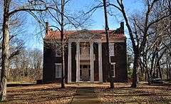
| 3 |
The Athenaeum |
|
000000001973-04-24-0000April 24, 1973
(#73001809) |
808 Athenaeum St.
35°36′51″N 87°02′29″W / 35.614167°N 87.041389°W / 35.614167; -87.041389 (The Athenaeum) |
Columbia |
|
| 4 |
Beechlawn Advance and Retreat |
Upload image |
000000001971-05-14-0000May 14, 1971
(#71000824) |
South of Columbia on U.S. Route 31
35°34′08″N 87°02′32″W / 35.568889°N 87.042222°W / 35.568889; -87.042222 (Beechlawn Advance and Retreat) |
Columbia |
|
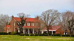
| 5 |
Blythewood |
Upload image |
000000001973-04-11-0000April 11, 1973
(#73001810) |
Trotwood and Hatcher Lane
35°36′18″N 87°03′49″W / 35.604948°N 87.063735°W / 35.604948; -87.063735 (Blythewood) |
Columbia |
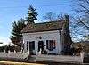
|
| 6 |
Merritt H. Booker House |
Upload image |
000000001985-07-18-0000July 18, 1985
(#85001561) |
Scott Hollow Rd.
35°28′15″N 87°00′33″W / 35.470833°N 87.009167°W / 35.470833; -87.009167 (Merritt H. Booker House) |
Culleoka |
|
| 7 |
Breckenridge Hatter's Shop |
|
000000001984-12-13-0000December 13, 1984
(#84000613) |
N. Main St.
35°32′07″N 87°12′23″W / 35.535278°N 87.206389°W / 35.535278; -87.206389 (Breckenridge Hatter's Shop) |
Mount Pleasant |
|
| 8 |
Martin Cheairs House |
|
000000001976-12-12-0000December 12, 1976
(#76001787) |
U.S. Route 31
35°44′53″N 86°55′54″W / 35.748056°N 86.931667°W / 35.748056; -86.931667 (Martin Cheairs House) |
Spring Hill |
|
| 9 |
Church House |
|
000000001978-10-19-0000October 19, 1978
(#78002609) |
312 W. 7th St.
35°36′56″N 87°02′19″W / 35.615556°N 87.038611°W / 35.615556; -87.038611 (Church House) |
Columbia |
|
| 10 |
Cleburne Jersey Farm |
Upload image |
000000002000-11-22-0000November 22, 2000
(#00001430) |
2319 Sugar Ridge Rd.
35°46′32″N 86°56′19″W / 35.775556°N 86.938611°W / 35.775556; -86.938611 (Cleburne Jersey Farm) |
Spring Hill |
|
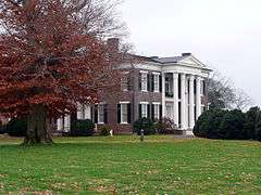
| 11 |
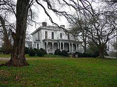
Clifton Place |
Upload image |
000000001970-07-08-0000July 8, 1970
(#70000613) |
Southwest of Columbia on the Mt. Pleasant Highway
35°34′40″N 87°06′52″W / 35.577778°N 87.114444°W / 35.577778; -87.114444 (Clifton Place) |
Columbia |
|
| 12 |
Columbia Arsenal |
|
000000001977-09-19-0000September 19, 1977
(#77001281) |
W. 7th St.
35°36′53″N 87°03′30″W / 35.614722°N 87.058333°W / 35.614722; -87.058333 (Columbia Arsenal) |
Columbia |
|
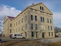
| 13 |
Columbia Central High School |
|
000000001980-04-21-0000April 21, 1980
(#80003848) |
W. 8th St.
35°36′49″N 87°02′29″W / 35.613611°N 87.041389°W / 35.613611; -87.041389 (Columbia Central High School) |
Columbia |
|
| 14 |
Columbia Commercial Historic District |
|
000000001984-08-16-0000August 16, 1984
(#84003625) |
Roughly bounded by 7th, 8th, Woodland, and High St.
35°36′50″N 87°02′04″W / 35.613889°N 87.034444°W / 35.613889; -87.034444 (Columbia Commercial Historic District) |
Columbia |
|
| 15 |
Columbia Hydroelectric Station |
|
000000001990-02-09-0000February 9, 1990
(#89002364) |
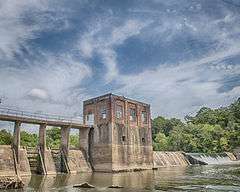
Riverside Park, Riverside Dr., and the Duck River
35°36′56″N 87°00′53″W / 35.615556°N 87.014722°W / 35.615556; -87.014722 (Columbia Hydroelectric Station) |
Columbia |
|
| 16 |
Columbia West End Historic District |
Upload image |
000000001986-03-13-0000March 13, 1986
(#86000394) |
Roughly along W. 7th St. between Frierson St. and the former Seaboard System railroad line
35°36′58″N 87°02′49″W / 35.616111°N 87.046944°W / 35.616111; -87.046944 (Columbia West End Historic District) |
Columbia |
|
| 17 |
Culleoka Methodist Episcopal Church, South |
Upload image |
000000001986-05-22-0000May 22, 1986
(#86001134) |
Quality St.
35°28′53″N 86°59′06″W / 35.481389°N 86.985°W / 35.481389; -86.985 (Culleoka Methodist Episcopal Church, South) |
Culleoka |
|
| 18 |
Derryberry House |
Upload image |
000000001990-11-07-0000November 7, 1990
(#90001656) |
New Lasea Rd. east of its junction with Interstate 65
35°40′21″N 86°52′40″W / 35.6725°N 86.877778°W / 35.6725; -86.877778 (Derryberry House) |
Spring Hill |
|
| 19 |
Elm Springs |
Upload image |
000000001986-03-13-0000March 13, 1986
(#86000402) |
Mooresville Pike
35°35′05″N 87°01′50″W / 35.584722°N 87.030556°W / 35.584722; -87.030556 (Elm Springs) |
Columbia |
|
| 20 |
Ewell Farm |
|
000000001976-05-24-0000May 24, 1976
(#76001788) |
Depot Lane
35°45′38″N 86°56′37″W / 35.760556°N 86.943611°W / 35.760556; -86.943611 (Ewell Farm) |
Spring Hill |
|
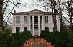
| 21 |
Fairmont |
Upload image |
000000001983-09-01-0000September 1, 1983
(#83003052) |
Mooresville Pike
35°35′10″N 87°01′31″W / 35.586111°N 87.025278°W / 35.586111; -87.025278 (Fairmont) |
Columbia |
|
| 22 |
First United Methodist Church of Columbia |
|
000000001984-08-30-0000August 30, 1984
(#84003628) |
222 W. 7th St.
35°36′55″N 87°02′11″W / 35.615278°N 87.036389°W / 35.615278; -87.036389 (First United Methodist Church of Columbia) |
Columbia |
|
| 23 |
Lucius Frierson House |
Upload image |
000000001978-09-01-0000September 1, 1978
(#78002610) |
W. 7th St.
35°36′57″N 87°02′25″W / 35.615833°N 87.040278°W / 35.615833; -87.040278 (Lucius Frierson House) |
Columbia |
|
| 24 |
John Gordon House |
|
000000001974-04-18-0000April 18, 1974
(#74000333) |
Northwest of Williamsport off State Route 50
35°43′11″N 87°15′38″W / 35.719722°N 87.260556°W / 35.719722; -87.260556 (John Gordon House) |
Williamsport |
|
| 25 |
Grace Episcopal Church |
|
000000001976-05-17-0000May 17, 1976
(#76001789) |
U.S. Route 31
35°45′09″N 86°55′45″W / 35.7525°N 86.929167°W / 35.7525; -86.929167 (Grace Episcopal Church) |
Spring Hill |
|
| 26 |
Hamilton Place |
Upload image |
000000001973-07-16-0000July 16, 1973
(#73001812) |
Mt. Pleasant Pike, west of Columbia off U.S. Route 43
35°34′18″N 87°09′11″W / 35.571667°N 87.153056°W / 35.571667; -87.153056 (Hamilton Place) |
Columbia |
|
| 27 |
James Kennedy House |
Upload image |
000000001987-11-06-0000November 6, 1987
(#87001780) |
Rogers Ford Rd.
35°39′25″N 86°59′45″W / 35.656944°N 86.995833°W / 35.656944; -86.995833 (James Kennedy House) |
Columbia |
|
| 28 |
Patrick Maguire House |
Upload image |
000000001983-12-15-0000December 15, 1983
(#83004270) |
105 N. Campbell Boulevard
35°37′34″N 87°02′28″W / 35.626111°N 87.041111°W / 35.626111; -87.041111 (Patrick Maguire House) |
Columbia |
|
| 29 |
Dr. Samuel Mayes House |
Upload image |
000000001993-10-25-0000October 25, 1993
(#93000345) |
Junction of Zion Ln. and Canaan Rd.
35°36′00″N 87°10′53″W / 35.6°N 87.181389°W / 35.6; -87.181389 (Dr. Samuel Mayes House) |
Columbia |
|
| 30 |
Mayes-Hutton House |
|
000000001970-07-08-0000July 8, 1970
(#70000614) |
306 W. 6th St.
35°37′01″N 87°02′17″W / 35.616944°N 87.038056°W / 35.616944; -87.038056 (Mayes-Hutton House) |
Columbia |
|
| 31 |
Mercer Hall |
|
000000001982-12-16-0000December 16, 1982
(#82001730) |
902 Mercer Ct.
35°36′35″N 87°02′46″W / 35.609722°N 87.046111°W / 35.609722; -87.046111 (Mercer Hall) |
Columbia |
|
| 32 |
Washington Miller House |
Upload image |
000000002012-11-14-0000November 14, 2012
(#12000944) |
1450 Frye Rd.
35°42′04″N 86°59′25″W / 35.701045°N 86.99024°W / 35.701045; -86.99024 (Washington Miller House) |
Columbia |
|
| 33 |
Mount Pleasant Commercial Historic District |
Upload image |
000000002003-11-13-0000November 13, 2003
(#03001160) |
Roughly bounded by N. and S. Main Sts., Public Sq., and Hay Long Ave.
35°32′05″N 87°12′26″W / 35.534601°N 87.207309°W / 35.534601; -87.207309 (Mount Pleasant Commercial Historic District) |
Mount Pleasant |
|
| 34 |
North Main Street Historic District |
Upload image |
000000001989-08-08-0000August 8, 1989
(#89000263) |
Roughly N. Main St. from Shofner St. to 3rd St.
35°32′24″N 87°12′14″W / 35.54°N 87.203889°W / 35.54; -87.203889 (North Main Street Historic District) |
Mount Pleasant |
|
| 35 |
Old Natchez Trace |
|
000000001975-05-30-0000May 30, 1975
(#75002125) |
From the Alabama/Tennessee border to State Route 100 in Davidson County
Coordinates missing |
Santa Fe |
Extends into Davidson, Hickman, Lawrence, Lewis, Wayne, and Williamson counties
|
| 36 |
Pillow Place |
Upload image |
000000001983-12-08-0000December 8, 1983
(#83004271) |
Campbellsville Pike
35°34′17″N 87°04′52″W / 35.571389°N 87.081111°W / 35.571389; -87.081111 (Pillow Place) |
Columbia |
|
| 37 |
Pillow-Bethel House |
Upload image |
000000001976-12-12-0000December 12, 1976
(#76001785) |
Southwest of Columbia off U.S. Route 43
35°34′05″N 87°06′56″W / 35.568056°N 87.115556°W / 35.568056; -87.115556 (Pillow-Bethel House) |
Columbia |
|
| 38 |
Pine Hill |
Upload image |
000000001983-12-15-0000December 15, 1983
(#83004272) |
Old Zion Lane
35°35′11″N 87°07′39″W / 35.586389°N 87.1275°W / 35.586389; -87.1275 (Pine Hill) |
Ashwood |
|
| 39 |
Pleasant Historic District |
Upload image |
000000001989-08-08-0000August 8, 1989
(#89000264) |
Roughly bounded by Haylong Ave., Pleasant, Bond, Wheeler, Adams, and Cherry Sts., Washington Ave., and College St.
35°32′06″N 87°12′48″W / 35.535°N 87.213333°W / 35.535; -87.213333 (Pleasant Historic District) |
Mount Pleasant |
|
| 40 |
Pleasant Mount Cumberland Presbyterian Church |
Upload image |
000000001977-08-16-0000August 16, 1977
(#77001282) |
Southeast of Columbia off State Route 50
35°32′32″N 86°58′08″W / 35.542222°N 86.968889°W / 35.542222; -86.968889 (Pleasant Mount Cumberland Presbyterian Church) |
Columbia |
|
| 41 |
Polk Sisters' House |
|
000000001975-05-21-0000May 21, 1975
(#75001770) |
305 W. 7th St.
35°36′54″N 87°02′16″W / 35.615°N 87.037778°W / 35.615; -87.037778 (Polk Sisters' House) |
Columbia |
|
| 42 |
James K. Polk House |
|
000000001966-10-15-0000October 15, 1966
(#66000728) |
W. 7th and S. High Sts.
35°36′54″N 87°02′14″W / 35.615°N 87.037222°W / 35.615; -87.037222 (James K. Polk House) |
Columbia |
|
| 43 |
Prewitt-Amis-Finney House |
Upload image |
000000001997-12-01-0000December 1, 1997
(#97001503) |
2629 Pullen Mill Rd.
35°27′44″N 87°00′02″W / 35.462222°N 87.000556°W / 35.462222; -87.000556 (Prewitt-Amis-Finney House) |
Culleoka |
|
| 44 |
Rally Hill |
Upload image |
000000001984-08-16-0000August 16, 1984
(#84003638) |
319 W. 8th St.
35°36′48″N 87°02′20″W / 35.613333°N 87.038889°W / 35.613333; -87.038889 (Rally Hill) |
Columbia |
|
| 45 |
Rattle and Snap |
|
000000001971-11-11-0000November 11, 1971
(#71000825) |
Andrew Jackson Highway (State Route 43)
35°33′38″N 87°09′12″W / 35.560556°N 87.153333°W / 35.560556; -87.153333 (Rattle and Snap) |
Columbia |
|
| 46 |
Rippavilla |
|
000000001996-07-19-0000July 19, 1996
(#96000773) |
U.S. Route 31, approximately 1.5 miles south of its junction with Kedron Rd.
35°43′54″N 86°57′14″W / 35.731667°N 86.953889°W / 35.731667; -86.953889 (Rippavilla) |
Spring Hill |
|
| 47 |
Ritter-Morton House |
|
000000001976-12-12-0000December 12, 1976
(#76001790) |
McLemore Ave.
35°45′02″N 86°55′45″W / 35.750556°N 86.929167°W / 35.750556; -86.929167 (Ritter-Morton House) |
Spring Hill |
|
| 48 |
Rockdale Furnace Historic District (40MU487) |
Upload image |
000000001988-07-21-0000July 21, 1988
(#88001100) |
Address Restricted
|
Rockdale |
|
| 49 |
St. John's Episcopal Church |
|
000000001970-07-08-0000July 8, 1970
(#70000615) |
West of Columbia on U.S. Route 43
35°34′27″N 87°08′20″W / 35.574167°N 87.138889°W / 35.574167; -87.138889 (St. John's Episcopal Church) |
Columbia |
|
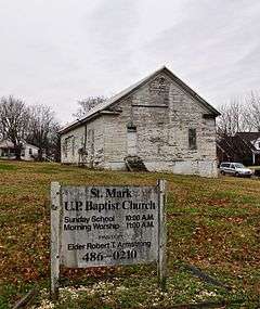
| 50 |
St. Mark United Primitive Baptist Church |
|
000000002000-07-14-0000July 14, 2000
(#00000811) |
Maury Hill St.
35°45′01″N 86°55′58″W / 35.750278°N 86.932778°W / 35.750278; -86.932778 (St. Mark United Primitive Baptist Church) |
Spring Hill |
|
| 51 |
St. Peter's Episcopal Church |
|
000000001979-06-27-0000June 27, 1979
(#79002448) |
311 W. 7th St.
35°36′52″N 87°02′18″W / 35.614444°N 87.038333°W / 35.614444; -87.038333 (St. Peter's Episcopal Church) |
Columbia |
|
| 52 |
Andrew Scott House |
Upload image |
000000001995-08-04-0000August 4, 1995
(#95000976) |
3991 Pulaski Highway
35°27′57″N 87°02′31″W / 35.465833°N 87.041944°W / 35.465833; -87.041944 (Andrew Scott House) |
Culleoka |
|
| 53 |
Shelby Bend Archeological District |
Upload image |
000000001990-02-01-0000February 1, 1990
(#89001760) |
Address Restricted
|
Greenfield Bend |
Extends into Hickman County
|
| 54 |
Skipwith Hall |
Upload image |
000000001977-11-23-0000November 23, 1977
(#77001283) |
West of Columbia on State Route 50
35°38′29″N 87°08′35″W / 35.641389°N 87.143056°W / 35.641389; -87.143056 (Skipwith Hall) |
Columbia |
|
| 55 |
Spring Hill Presbyterian Church |
|
000000001984-07-19-0000July 19, 1984
(#84003640) |
S. Main St.
35°44′56″N 86°55′52″W / 35.748889°N 86.931111°W / 35.748889; -86.931111 (Spring Hill Presbyterian Church) |
Spring Hill |
|
| 56 |
State Bank of Tennessee |
Upload image |
000000001978-11-02-0000November 2, 1978
(#78002611) |
201 W. 7th St.
35°36′53″N 87°02′09″W / 35.614722°N 87.035833°W / 35.614722; -87.035833 (State Bank of Tennessee) |
Columbia |
|
| 57 |
Absalom Thompson House |
Upload image |
000000001979-09-11-0000September 11, 1979
(#79002449) |
South of Spring Hill on Denning Rd
35°43′19″N 86°55′47″W / 35.721944°N 86.929722°W / 35.721944; -86.929722 (Absalom Thompson House) |
Spring Hill |
|
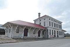
| 58 |
Union Station |
|
000000001986-10-23-0000October 23, 1986
(#86002908) |
Depot St.
35°36′29″N 87°02′14″W / 35.608056°N 87.037222°W / 35.608056; -87.037222 (Union Station) |
Columbia |
|
| 59 |
Vine Hill |
|
000000001983-07-15-0000July 15, 1983
(#83003053) |
Sawdust Rd.
35°38′47″N 87°12′47″W / 35.646389°N 87.213056°W / 35.646389; -87.213056 (Vine Hill) |
Cross Bridges |
|
| 60 |
Walnut Grove |
|
000000001984-03-08-0000March 8, 1984
(#84003641) |
510 N. Main St.
35°32′25″N 87°12′11″W / 35.540278°N 87.203056°W / 35.540278; -87.203056 (Walnut Grove) |
Mount Pleasant |
|
| 61 |
William Watkins House |
Upload image |
000000001986-10-23-0000October 23, 1986
(#86002901) |
Canaan Rd.
35°33′53″N 87°11′39″W / 35.564722°N 87.194167°W / 35.564722; -87.194167 (William Watkins House) |
Mount Pleasant |
|
| 62 |
Webster Farm |
|
000000001996-07-19-0000July 19, 1996
(#96000770) |
3166 Hampshire Pike
35°37′19″N 87°13′15″W / 35.621944°N 87.220833°W / 35.621944; -87.220833 (Webster Farm) |
Cross Bridges |
|
| 63 |
George Webster House |
Upload image |
000000001984-04-05-0000April 5, 1984
(#84003646) |
Sawdust Rd.
35°38′02″N 87°12′44″W / 35.633889°N 87.212222°W / 35.633889; -87.212222 (George Webster House) |
Williamsport |
|
| 64 |
West Sixth Street and Mayes Place Historic District |
Upload image |
000000001978-02-25-0000February 25, 1978
(#78002612) |
W. 6th St. and Mayes Pl.
35°37′00″N 87°02′18″W / 35.616667°N 87.038333°W / 35.616667; -87.038333 (West Sixth Street and Mayes Place Historic District) |
Columbia |
|
| 65 |
White Hall |
|
000000001984-04-05-0000April 5, 1984
(#84003661) |
Duplex Rd.
35°45′08″N 86°55′32″W / 35.752222°N 86.925556°W / 35.752222; -86.925556 (White Hall) |
Spring Hill |
|
| 66 |
Zion Presbyterian Church |
|
000000001972-06-13-0000June 13, 1972
(#72001245) |
6.3 miles west of Columbia off State Route 99
Coordinates missing |
Columbia |
|


.jpg)

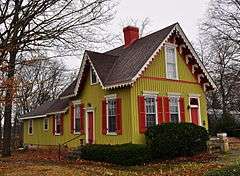
.jpg)
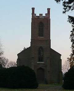
%2C_State_Route_1%2C_Columbia_vicinity_(Maury_County%2C_Tennessee).jpg)