National Register of Historic Places listings in Monroe County, Tennessee
Location of Monroe County in Tennessee
This is a list of the National Register of Historic Places listings in Monroe County, Tennessee.
This is intended to be a complete list of the properties and districts on the National Register of Historic Places in Monroe County, Tennessee, United States. Latitude and longitude coordinates are provided for many National Register properties and districts; these locations may be seen together in a map.[1]
There are currently 18 properties listed on the National Register in the county, including 1 National Historic Landmark.
| Anderson – Bedford – Benton – Bledsoe – Blount – Bradley – Campbell – Cannon – Carroll – Carter – Cheatham – Chester – Claiborne – Clay – Cocke – Coffee – Crockett – Cumberland – Davidson – Decatur – DeKalb – Dickson – Dyer – Fayette – Fentress – Franklin – Gibson – Giles – Grainger – Greene – Grundy – Hamblen – Hamilton – Hancock – Hardeman – Hardin – Hawkins – Haywood – Henderson – Henry – Hickman – Houston – Humphreys – Jackson – Jefferson – Johnson – Knox – Lake – Lauderdale – Lawrence – Lewis – Lincoln – Loudon – Macon – Madison – Marion – Marshall – Maury – McMinn – McNairy – Meigs – Monroe – Montgomery – Moore – Morgan – Obion – Overton – Perry – Pickett – Polk – Putnam – Rhea – Roane – Robertson – Rutherford – Scott – Sequatchie – Sevier – Shelby – Smith – Stewart – Sullivan – Sumner – Tipton – Trousdale – Unicoi – Union – Van Buren – Warren – Washington – Wayne – Weakley – White – Williamson – Wilson |
- This National Park Service list is complete through NPS recent listings posted December 2, 2016.[2]
Current listings
| [3] | Name on the Register[4] | Image | Date listed[5] | Location | City or town | Description |
|---|---|---|---|---|---|---|
| 1 | Calderwood Dam | 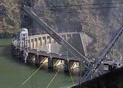 |
(#89001069) |
Tennessee River at the end of Calderwood Rd. 35°29′32″N 83°58′58″W / 35.492222°N 83.982778°W |
Calderwood | Extends into Blount County |
| 2 | Chota and Tanasi Cherokee Village Sites | 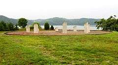 |
(#73001813) |
Address Restricted |
Vonore | Archaeological sites for 18th-century Cherokee villages of Chota and Tanasi; now submerged under Tellico Lake, though both sites memorialized with monuments along the shoreline |
| 3 | Citico Site |  |
(#78002614) |
Address Restricted |
Vonore | Archaeological site for 18th-century Cherokee village; now submerged by Tellico Lake |
| 4 | Cooke-Kefauver House |  |
(#74001921) |
Kefauver Lane 35°30′40″N 84°21′28″W / 35.511111°N 84.357778°W |
Madisonville | |
| 5 | First Presbyterian Church |  |
(#01000772) |
601 Church St. 35°36′09″N 84°27′49″W / 35.6025°N 84.463611°W |
Sweetwater | Gothic Revival-style church; congregation founded in 1860, church built in 1887 |
| 6 | Fort Loudoun | 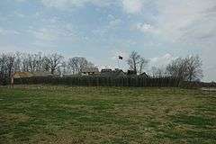 |
(#66000729) |
U.S. Route 411 35°35′45″N 84°12′13″W / 35.595833°N 84.203611°W |
Vonore | |
| 7 | William J. Fowler Mill and House | Upload image | (#83003057) |
Sweetwater Rd. 35°38′35″N 84°18′43″W / 35.643056°N 84.311944°W |
Eve Mills | |
| 8 | Icehouse Bottom Site | 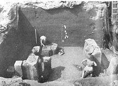 |
(#78002615) |
Address Restricted |
Vonore | Archaic and Woodland period site excavated in the early 1970s; now submerged by Tellico Lake |
| 9 | Elisha Johnson Mansion | Upload image | (#74001923) |
Ballplay Rd. 35°21′30″N 84°16′25″W / 35.358333°N 84.273611°W |
Tellico Plains | |
| 10 | John McCroskey House | 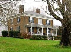 |
(#00000125) |
3224 Sweetwater-Vonore Rd. 35°36′33″N 84°21′15″W / 35.609167°N 84.354167°W |
Sweetwater | Built in 1859 |
| 11 | Mialoquo Site | |
(#78002616) |
Address Restricted |
Vonore | Archaeological site for 18th-century Cherokee village; now submerged by Tellico Lake |
| 12 | Monroe County Courthouse | 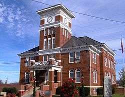 |
(#95000341) |
Town Sq. 35°31′11″N 84°21′46″W / 35.519722°N 84.362778°W |
Madisonville | |
| 13 | Charles Owen House |  |
(#98000875) |
1019 Mayes St. 35°36′31″N 84°27′47″W / 35.608611°N 84.463056°W |
Sweetwater | Federal-style house built in the late 1820s |
| 14 | Scott Mansion | Upload image | (#92001816) |
Scott Mansion Rd., about 1¼ miles east of State Route 68 35°23′13″N 84°17′20″W / 35.386944°N 84.288889°W |
Tellico Plains | |
| 15 | Stickley House |  |
(#74001922) |
West of the junction of U.S. Route 411 and State Route 68 35°31′09″N 84°21′58″W / 35.519167°N 84.366111°W |
Madisonville | Greek Revival-style house built in 1846, and designed by architect Thomas Blanchard |
| 16 | Tellico Blockhouse Site | 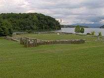 |
(#75001771) |
2 miles east of Vonore off State Route 72 35°36′00″N 84°12′11″W / 35.6°N 84.203056°W |
Vonore | Late 18th-century trading outpost; layout marked by posts and stones, with interpretive signs |
| 17 | Tomotley Site |  |
(#78002617) |
Address Restricted |
Vonore | Archaeological site for 18th-century Cherokee village; now submerged by Tellico Lake |
| 18 | Toqua Site |  |
(#78002618) |
Address Restricted |
Vonore | Archaeological site for 18th-century Cherokee village; now submerged by Tellico Lake |
Former listings
| [3] | Name on the Register | Image | Date listed | Date removed | Location | City or town | Summary |
|---|---|---|---|---|---|---|---|
| 1 | McGhee Mansion | Upload image | (#74001924) | E of Vonore on Fort Loudoun Rd. |
Vonore | Also known as Tuskega. Burned down by arsonist November 14, 1984. |
See also
| Wikimedia Commons has media related to National Register of Historic Places in Monroe County, Tennessee. |
- List of National Historic Landmarks in Tennessee
- National Register of Historic Places listings in Tennessee
References
- ↑ The latitude and longitude information provided in this table was derived originally from the National Register Information System, which has been found to be fairly accurate for about 99% of listings. For about 1% of NRIS original coordinates, experience has shown that one or both coordinates are typos or otherwise extremely far off; some corrections may have been made. A more subtle problem causes many locations to be off by up to 150 yards, depending on location in the country: most NRIS coordinates were derived from tracing out latitude and longitudes off of USGS topographical quadrant maps created under the North American Datum of 1927, which differs from the current, highly accurate WGS84 GPS system used by most on-line maps. Chicago is about right, but NRIS longitudes in Washington are higher by about 4.5 seconds, and are lower by about 2.0 seconds in Maine. Latitudes differ by about 1.0 second in Florida. Some locations in this table may have been corrected to current GPS standards.
- ↑ "National Register of Historic Places: Weekly List Actions". National Park Service, United States Department of the Interior. Retrieved on December 2, 2016.
- 1 2 Numbers represent an ordering by significant words. Various colorings, defined here, differentiate National Historic Landmarks and historic districts from other NRHP buildings, structures, sites or objects.
- ↑ National Park Service (2008-04-24). "National Register Information System". National Register of Historic Places. National Park Service.
- ↑ The eight-digit number below each date is the number assigned to each location in the National Register Information System database, which can be viewed by clicking the number.
| Topics | |
|---|---|
| Lists by states |
|
| Lists by insular areas | |
| Lists by associated states | |
| Other areas | |
| |
Municipalities and communities of Monroe County, Tennessee, United States | ||
|---|---|---|
| Cities | ||
| Towns | ||
| Unincorporated communities |
| |
| Footnotes | ‡This populated place also has portions in an adjacent county or counties | |
This article is issued from Wikipedia - version of the 6/15/2016. The text is available under the Creative Commons Attribution/Share Alike but additional terms may apply for the media files.