National Register of Historic Places listings in Stewart County, Tennessee
This is a list of the National Register of Historic Places listings in Stewart County, Tennessee.
This is intended to be a complete list of the properties and districts on the National Register of Historic Places in Stewart County, Tennessee, United States. Latitude and longitude coordinates are provided for many National Register properties and districts; these locations may be seen together in a map.[1]
There are 15 properties and districts listed on the National Register in the county. Ten of these are the ruins of iron furnaces. In the 19th century, Stewart County was a major center for iron mining and production. Production of iron in the county began some time shortly before 1828 and continued until 1927, when the last blast furnace shut down. All of the county's iron furnaces were "stone stack" cold-blast furnaces that used charcoal obtained from burning timber from local forests.[2]
| Anderson – Bedford – Benton – Bledsoe – Blount – Bradley – Campbell – Cannon – Carroll – Carter – Cheatham – Chester – Claiborne – Clay – Cocke – Coffee – Crockett – Cumberland – Davidson – Decatur – DeKalb – Dickson – Dyer – Fayette – Fentress – Franklin – Gibson – Giles – Grainger – Greene – Grundy – Hamblen – Hamilton – Hancock – Hardeman – Hardin – Hawkins – Haywood – Henderson – Henry – Hickman – Houston – Humphreys – Jackson – Jefferson – Johnson – Knox – Lake – Lauderdale – Lawrence – Lewis – Lincoln – Loudon – Macon – Madison – Marion – Marshall – Maury – McMinn – McNairy – Meigs – Monroe – Montgomery – Moore – Morgan – Obion – Overton – Perry – Pickett – Polk – Putnam – Rhea – Roane – Robertson – Rutherford – Scott – Sequatchie – Sevier – Shelby – Smith – Stewart – Sullivan – Sumner – Tipton – Trousdale – Unicoi – Union – Van Buren – Warren – Washington – Wayne – Weakley – White – Williamson – Wilson |
- This National Park Service list is complete through NPS recent listings posted December 2, 2016.[3]
Current listings
| [4] | Name on the Register[5] | Image | Date listed[6] | Location | City or town | Description |
|---|---|---|---|---|---|---|
| 1 | Bear Spring Furnace (40SW207) | .jpg) |
(#88000259) |
Address Restricted |
Dover | |
| 2 | Bellwood Furnace (40SW210) | Upload image | (#88000382) |
Address Restricted |
Bumpus Mills | |
| 3 | Brunsoni Furnace (40SW219) | Upload image | (#88000255) |
Address Restricted |
Cumberland City | |
| 4 | Clark Furnace (40SW212) | 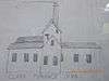 |
(#88000249) |
Address Restricted |
Standing Rock | |
| 5 | Cross Creek Furnace (40SW217) | Upload image | (#88000256) |
Address Restricted |
Indian Mound | |
| 6 | Dover Flint Quarries | Upload image | (#73001833) |
Address Restricted |
Dover | |
| 7 | Eclipse Furnace (40SW213) | .jpg) |
(#88000260) |
Address Restricted |
McKinnon | |
| 8 | Fort Donelson National Battlefield | .jpg) |
(#66000076) |
1 mile west of Dover on U.S. Route 79 36°29′14″N 87°51′07″W / 36.487222°N 87.851944°W |
Dover | |
| 9 | Fort Henry Site | Upload image | (#75001789) |
Northwest of Dover off U.S. Route 79 on Fort Henry Rd. 36°30′20″N 88°01′45″W / 36.505556°N 88.029167°W |
Dover | |
| 10 | Great Western Furnace | 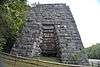 |
(#75001790) |
Northwest of Dover on State Route 49 36°38′24″N 87°58′32″W / 36.64°N 87.975556°W |
Dover | |
| 11 | Henry Hollister House | Upload image | (#88000262) |
Chapel Ridge Rd. 36°22′56″N 87°40′28″W / 36.382222°N 87.674444°W |
Cumberland City | |
| 12 | LaGrange Furnace (40SW214) |  |
(#88000383) |
Address Restricted |
McKinnon | |
| 13 | Rough and Ready Furnace (40SW215) | Upload image | (#88000251) |
Address Restricted |
Cumberland City | |
| 14 | Saline Furnace (40SW218) | Upload image | (#88000258) |
Address Restricted |
Bumpus Mills | |
| 15 | Samuel Stacker House | Upload image | (#88000257) |
Long Branch Rd. 36°27′39″N 87°47′42″W / 36.460833°N 87.795°W |
Dover |
See also
| Wikimedia Commons has media related to National Register of Historic Places in Stewart County, Tennessee. |
- List of National Historic Landmarks in Tennessee
- National Register of Historic Places listings in Tennessee
References
- ↑ The latitude and longitude information provided in this table was derived originally from the National Register Information System, which has been found to be fairly accurate for about 99% of listings. For about 1% of NRIS original coordinates, experience has shown that one or both coordinates are typos or otherwise extremely far off; some corrections may have been made. A more subtle problem causes many locations to be off by up to 150 yards, depending on location in the country: most NRIS coordinates were derived from tracing out latitude and longitudes off of USGS topographical quadrant maps created under the North American Datum of 1927, which differs from the current, highly accurate WGS84 GPS system used by most on-line maps. Chicago is about right, but NRIS longitudes in Washington are higher by about 4.5 seconds, and are lower by about 2.0 seconds in Maine. Latitudes differ by about 1.0 second in Florida. Some locations in this table may have been corrected to current GPS standards.
- ↑ "The Stewart County Iron Industry". Historical Markers Across Tennessee. Retrieved 2 September 2014.
- ↑ "National Register of Historic Places: Weekly List Actions". National Park Service, United States Department of the Interior. Retrieved on December 2, 2016.
- ↑ Numbers represent an ordering by significant words. Various colorings, defined here, differentiate National Historic Landmarks and historic districts from other NRHP buildings, structures, sites or objects.
- ↑ National Park Service (2008-04-24). "National Register Information System". National Register of Historic Places. National Park Service.
- ↑ The eight-digit number below each date is the number assigned to each location in the National Register Information System database, which can be viewed by clicking the number.
| Topics | |
|---|---|
| Lists by states |
|
| Lists by insular areas | |
| Lists by associated states | |
| Other areas | |
| |
Municipalities and communities of Stewart County, Tennessee, United States | ||
|---|---|---|
| City | ||
| Towns | ||
| Unincorporated communities | ||
| Ghost town | ||
| Footnotes | ‡This populated place also has portions in an adjacent county or counties | |