| [3] |
Name on the Register[4] |
Image |
Date listed[5] |
Location |
City or town |
Description |
|---|
| 1 |
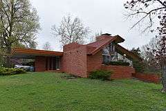
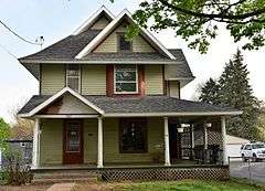
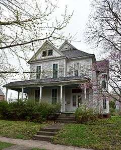
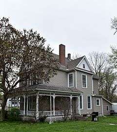
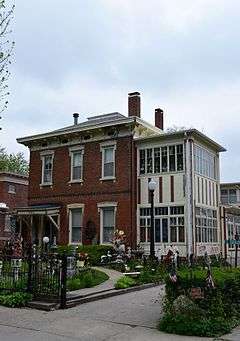
Carroll Alsop House |
|
000000001988-11-09-0000November 9, 1988
(#88002142) |
1907 A Ave., E.
41°17′49″N 92°37′21″W / 41.296944°N 92.6225°W / 41.296944; -92.6225 (Carroll Alsop House) |
Oskaloosa |
|
| 2 |
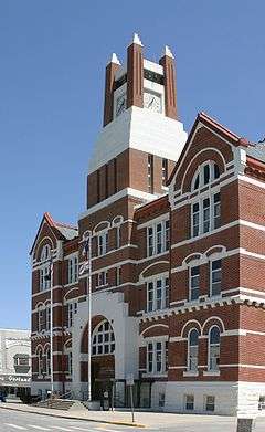
Bellefountain Bridge |
|
000000001998-05-15-0000May 15, 1998
(#98000506) |
Ashland Ave. over the Des Moines River
41°19′58″N 92°51′56″W / 41.332778°N 92.865556°W / 41.332778; -92.865556 (Bellefountain Bridge) |
Tracy |
|
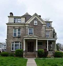
| 3 |
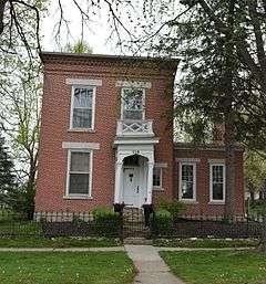
Dr. William E. and Ethel Rosenberger Berry House |
|
000000001996-03-29-0000March 29, 1996
(#96000343) |
116 Rosenberger Ave.
41°18′22″N 92°38′46″W / 41.306111°N 92.646111°W / 41.306111; -92.646111 (Dr. William E. and Ethel Rosenberger Berry House) |
Oskaloosa |
|
| 4 |
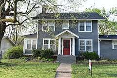
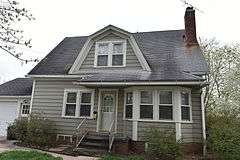
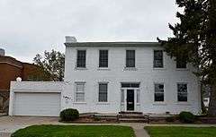
Thomas J. Conover House |
|
000000001996-03-28-0000March 28, 1996
(#96000342) |
1010 N. Market St.
41°18′14″N 92°38′39″W / 41.303889°N 92.644167°W / 41.303889; -92.644167 (Thomas J. Conover House) |
Oskaloosa |
|
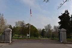
| 5 |
Edmundson Park Historic District |
|
000000002007-09-27-0000September 27, 2007
(#07001005) |
Junction of 11th Ave., W. and Edmundson Dr.
41°17′07″N 92°39′36″W / 41.28524°N 92.65991°W / 41.28524; -92.65991 (Edmundson Park Historic District) |
Oskaloosa |
|
| 6 |
Eveland Bridge |
|
000000001998-05-15-0000May 15, 1998
(#98000504) |
Fulton Ave. over the Des Moines River
41°14′34″N 92°45′24″W / 41.242708°N 92.756528°W / 41.242708; -92.756528 (Eveland Bridge) |
Oskaloosa |
|
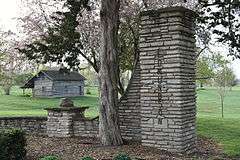
| 7 |
Forest Cemetery Entrance |
|
000000001991-12-13-0000December 13, 1991
(#91001765) |
Junction of N. 9th St. and J Ave., E.
41°18′12″N 92°38′02″W / 41.303333°N 92.633889°W / 41.303333; -92.633889 (Forest Cemetery Entrance) |
Oskaloosa |
|
| 8 |
E.H. Gibbs House |
Upload image |
000000001991-12-13-0000December 13, 1991
(#91001761) |
William Penn University campus, N. Market Extension
41°18′31″N 92°38′41″W / 41.308611°N 92.644722°W / 41.308611; -92.644722 (E.H. Gibbs House) |
Oskaloosa |
|
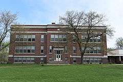
| 9 |
Ulysses Simpson Grant Elementary School |
|
000000002008-12-10-0000December 10, 2008
(#08001163) |
715 B Ave., E.
41°17′50″N 92°38′16″W / 41.29716°N 92.6378°W / 41.29716; -92.6378 (Ulysses Simpson Grant Elementary School) |
Oskaloosa |
|
| 10 |
Phil Hoffman House |
|
000000001991-12-13-0000December 13, 1991
(#91001760) |
807 High Ave., E.
41°17′44″N 92°38′09″W / 41.295556°N 92.635833°W / 41.295556; -92.635833 (Phil Hoffman House) |
Oskaloosa |
|
| 11 |
Iowa Yearly Meeting House-College Avenue Friends Church |
|
000000001996-03-29-0000March 29, 1996
(#96000344) |
912 N. C St.
41°18′12″N 92°38′53″W / 41.303333°N 92.648056°W / 41.303333; -92.648056 (Iowa Yearly Meeting House-College Avenue Friends Church) |
Oskaloosa |
|
| 12 |
William A. and Ida C. Johnson House |
|
000000001996-03-28-0000March 28, 1996
(#96000346) |
307 College Ave.
41°18′14″N 92°38′50″W / 41.303889°N 92.647222°W / 41.303889; -92.647222 (William A. and Ida C. Johnson House) |
Oskaloosa |
|
| 13 |
Dr. William H. and Mae R. Klose House |
|
000000001996-03-29-0000March 29, 1996
(#96000350) |
1002 Penn Boulevard
41°18′23″N 92°38′51″W / 41.306389°N 92.6475°W / 41.306389; -92.6475 (Dr. William H. and Mae R. Klose House) |
Oskaloosa |
|
| 14 |
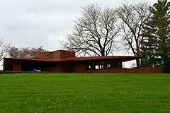
Lake Keomah State Park, Bathhouse-Lodge Area (Area A) |
Upload image |
000000001990-11-15-0000November 15, 1990
(#90001666) |
Off Iowa Highway 371 south of its junction with Iowa Highway 92
41°17′26″N 92°32′27″W / 41.290556°N 92.540833°W / 41.290556; -92.540833 (Lake Keomah State Park, Bathhouse-Lodge Area (Area A)) |
Oskaloosa |
|
| 15 |
Lake Keomah State Park, Erosion Control Area (Area B) |
Upload image |
000000001990-11-15-0000November 15, 1990
(#90001667) |
Off Iowa Highway 371 south of its junction with Iowa Highway 92
41°17′07″N 92°32′32″W / 41.285278°N 92.542222°W / 41.285278; -92.542222 (Lake Keomah State Park, Erosion Control Area (Area B)) |
Oskaloosa |
|
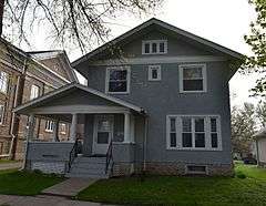
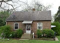
| 16 |
Jack Lamberson House |
|
000000001988-11-09-0000November 9, 1988
(#88002146) |
511 N. Park Ave.
41°18′01″N 92°37′37″W / 41.300278°N 92.626944°W / 41.300278; -92.626944 (Jack Lamberson House) |
Oskaloosa |
|
| 17 |
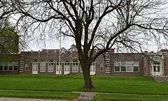
Lincoln School |
|
000000001991-12-13-0000December 13, 1991
(#91001766) |
911 B Ave., W.
41°17′51″N 92°39′17″W / 41.2975°N 92.654722°W / 41.2975; -92.654722 (Lincoln School) |
Oskaloosa |
|
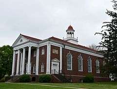
| 18 |
Mahaska County Courthouse |
|
000000001981-07-02-0000July 2, 1981
(#81000255) |
Market St. and 2nd Ave.
41°17′42″N 92°38′35″W / 41.295°N 92.643056°W / 41.295; -92.643056 (Mahaska County Courthouse) |
Oskaloosa |
|
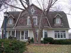
| 19 |
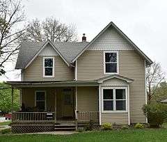
Maj. James W. McMullin House |
|
000000001985-04-11-0000April 11, 1985
(#85000723) |
403 1st Ave., E.
41°17′40″N 92°38′26″W / 41.294444°N 92.640556°W / 41.294444; -92.640556 (Maj. James W. McMullin House) |
Oskaloosa |
|
| 20 |
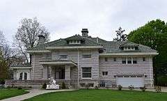
W.A. McNeill House |
|
000000001999-10-21-0000October 21, 1999
(#99001267) |
1282 C Ave., E.
41°17′54″N 92°37′36″W / 41.298333°N 92.626667°W / 41.298333; -92.626667 (W.A. McNeill House) |
Oskaloosa |
|
| 21 |
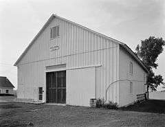
Daniel Nelson House and Barn |
|
000000001974-11-20-0000November 20, 1974
(#74000798) |
2211 Nelson Lane
41°19′14″N 92°37′50″W / 41.320556°N 92.630556°W / 41.320556; -92.630556 (Daniel Nelson House and Barn) |
Oskaloosa |
|
| 22 |
North Skunk River Bridge |
Upload image |
000000001998-05-15-0000May 15, 1998
(#98000503) |
County Road G13 over the North Skunk River
41°29′41″N 92°38′00″W / 41.494722°N 92.633333°W / 41.494722; -92.633333 (North Skunk River Bridge) |
New Sharon |
|
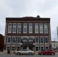
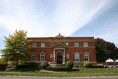
| 23 |
Oskaloosa City Hall |
|
000000001991-12-13-0000December 13, 1991
(#91001764) |
Northeastern corner of the junction of S. Market St. and 2nd Ave., E.
41°17′37″N 92°38′40″W / 41.293611°N 92.644444°W / 41.293611; -92.644444 (Oskaloosa City Hall) |
Oskaloosa |
|
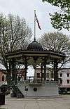
| 24 |
Oskaloosa City Park and Band Stand |
|
000000001983-07-28-0000July 28, 1983
(#83000389) |
City Park
41°17′42″N 92°38′38″W / 41.295°N 92.643889°W / 41.295; -92.643889 (Oskaloosa City Park and Band Stand) |
Oskaloosa |
|
| 25 |
Oskaloosa City Square Commercial Historic District |
|
000000001986-04-10-0000April 10, 1986
(#86000716) |
Roughly bounded by A Ave., E, N. and S. 2nd St., 2nd Ave., E, and N. and S. A St.
41°17′48″N 92°38′39″W / 41.296667°N 92.644167°W / 41.296667; -92.644167 (Oskaloosa City Square Commercial Historic District) |
Oskaloosa |
|
| 26 |
Oskaloosa Fire Station |
|
000000001991-12-13-0000December 13, 1991
(#91001763) |
109-111 2nd Ave., E.
41°17′37″N 92°38′39″W / 41.293611°N 92.644167°W / 41.293611; -92.644167 (Oskaloosa Fire Station) |
Oskaloosa |
|
| 27 |
Oskaloosa Monthly Meeting of Friends Parsonage |
|
000000001996-03-29-0000March 29, 1996
(#96000348) |
910 N. C St.
41°18′10″N 92°38′53″W / 41.302778°N 92.648056°W / 41.302778; -92.648056 (Oskaloosa Monthly Meeting of Friends Parsonage) |
Oskaloosa |
|
| 28 |
Oskaloosa Public Library |
|
000000001991-12-13-0000December 13, 1991
(#83004763) |
Southwestern corner of the junction of Market St. and 2nd Ave.
41°17′35″N 92°38′42″W / 41.293056°N 92.645°W / 41.293056; -92.645 (Oskaloosa Public Library) |
Oskaloosa |
|
| 29 |
Paradise Block Historic District |
|
000000001991-12-13-0000December 13, 1991
(#91001767) |
402, 406, 408, 410, 414, 418, and 510-714 High Ave. E.
41°17′43″N 92°38′18″W / 41.295278°N 92.638333°W / 41.295278; -92.638333 (Paradise Block Historic District) |
Oskaloosa |
|
| 30 |
Penn College Historic District |
|
000000001996-04-04-0000April 4, 1996
(#96000391) |
201 Trueblood Ave.
41°18′32″N 92°38′47″W / 41.308889°N 92.646389°W / 41.308889; -92.646389 (Penn College Historic District) |
Oskaloosa |
|
| 31 |
Pierson-Betts House |
|
000000001996-03-28-0000March 28, 1996
(#96000347) |
815 Penn Boulevard
41°18′22″N 92°38′52″W / 41.306111°N 92.647778°W / 41.306111; -92.647778 (Pierson-Betts House) |
Oskaloosa |
|
| 32 |
President's Cottage |
|
000000001996-03-28-0000March 28, 1996
(#96000340) |
425 College Ave.
41°18′13″N 92°39′00″W / 41.303611°N 92.65°W / 41.303611; -92.65 (President's Cottage) |
Oskaloosa |
|
| 33 |
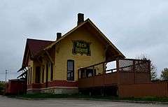
Rock Island Passenger Depot |
|
000000001989-10-30-0000October 30, 1989
(#89001780) |
Rock Island Ave. between 1st and 2nd Sts.
41°17′21″N 92°38′34″W / 41.289167°N 92.642778°W / 41.289167; -92.642778 (Rock Island Passenger Depot) |
Oskaloosa |
|
| 34 |
Rose Hill Methodist Episcopal Church |
|
000000002003-04-11-0000April 11, 2003
(#03000201) |
304 Main St.
41°19′14″N 92°27′55″W / 41.320556°N 92.465278°W / 41.320556; -92.465278 (Rose Hill Methodist Episcopal Church) |
Rose Hill |
|
| 35 |
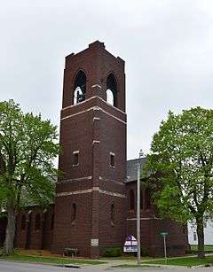
St. James Episcopal Church |
|
000000001991-12-13-0000December 13, 1991
(#91001762) |
Southwestern corner of the junction of 1st Ave. and S. 3rd St.
41°17′39″N 92°38′29″W / 41.294167°N 92.641389°W / 41.294167; -92.641389 (St. James Episcopal Church) |
Oskaloosa |
|
| 36 |
Seeberger-Loring-Kilburn House |
|
000000001983-07-14-0000July 14, 1983
(#83000390) |
509 High Ave., E.
41°17′44″N 92°38′22″W / 41.295556°N 92.639444°W / 41.295556; -92.639444 (Seeberger-Loring-Kilburn House) |
Oskaloosa |
|
| 37 |
John H. Shoemake House |
|
000000001984-03-22-0000March 22, 1984
(#84001276) |
116 2nd Ave., W.
41°17′36″N 92°38′44″W / 41.293333°N 92.645556°W / 41.293333; -92.645556 (John H. Shoemake House) |
Oskaloosa |
|
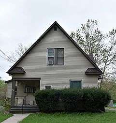
| 38 |
Smith-Johnson House |
|
000000001977-11-09-0000November 9, 1977
(#77000538) |
713 High Ave., E.
41°17′44″N 92°38′13″W / 41.295556°N 92.636944°W / 41.295556; -92.636944 (Smith-Johnson House) |
Oskaloosa |
|
| 39 |
Spring Creek Friends Cemetery |
Upload image |
000000001996-03-29-0000March 29, 1996
(#96000351) |
Junction of Osburn Ave. and 235th St.
41°18′41″N 92°36′09″W / 41.311389°N 92.6025°W / 41.311389; -92.6025 (Spring Creek Friends Cemetery) |
Oskaloosa |
|
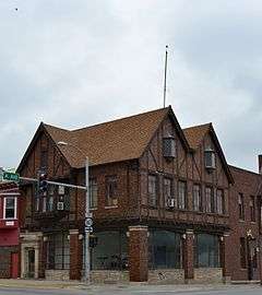
| 40 |
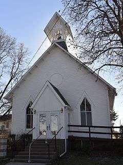
Spring Creek Meeting House-H Street Mission |
Upload image |
000000001996-03-28-0000March 28, 1996
(#96000339) |
207 N. H St.
41°17′47″N 92°39′17″W / 41.296389°N 92.654722°W / 41.296389; -92.654722 (Spring Creek Meeting House-H Street Mission) |
Oskaloosa |
|
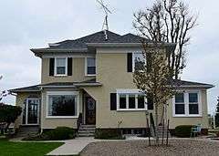
| 41 |
Spurgin Residence |
|
000000001996-03-28-0000March 28, 1996
(#96000341) |
313 College Ave.
41°18′14″N 92°39′00″W / 41.303889°N 92.65°W / 41.303889; -92.65 (Spurgin Residence) |
Oskaloosa |
|
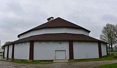
| 42 |
Stock Judging Pavilion |
|
000000001984-04-12-0000April 12, 1984
(#84001280) |
Southern Iowa Fairgrounds
41°18′04″N 92°39′43″W / 41.301111°N 92.661944°W / 41.301111; -92.661944 (Stock Judging Pavilion) |
Oskaloosa |
|
| 43 |
Dr. Ella Stokes House |
|
000000001996-03-29-0000March 29, 1996
(#96000349) |
416 W. College Hill Ave.
41°18′21″N 92°38′59″W / 41.305833°N 92.649722°W / 41.305833; -92.649722 (Dr. Ella Stokes House) |
Oskaloosa |
|
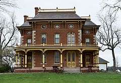
| 44 |
Prof. Edgar H. and Irene D. Stranahan House |
|
000000001996-03-28-0000March 28, 1996
(#96000345) |
1001 Gurney St.
41°18′23″N 92°38′49″W / 41.306389°N 92.646944°W / 41.306389; -92.646944 (Prof. Edgar H. and Irene D. Stranahan House) |
Oskaloosa |
|
| 45 |
Vander Wilt Farmstead Historic District |
|
000000002004-01-08-0000January 8, 2004
(#03001370) |
1345 Iowa Highway 163, Sec. 22, T26N, R17W, SW of NE
41°22′22″N 92°48′11″W / 41.372778°N 92.803056°W / 41.372778; -92.803056 (Vander Wilt Farmstead Historic District) |
Leighton |
|
| 46 |
John K. Voorhees House |
|
000000001982-03-05-0000March 5, 1982
(#82002632) |
Northwest of Oskaloosa on Iowa Highway 163
41°23′09″N 92°49′22″W / 41.385833°N 92.822778°W / 41.385833; -92.822778 (John K. Voorhees House) |
Oskaloosa |
|