| [3] |
Name on the Register[4] |
Image |
Date listed[5] |
Location |
City or town |
Description |
|---|
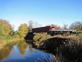
| 1 |
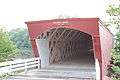
James Allen Stone Barn |
Upload image |
000000001987-09-29-0000September 29, 1987
(#87001658) |
2½ miles southeast of Earlham
41°26′56″N 94°06′20″W / 41.448889°N 94.105556°W / 41.448889; -94.105556 (James Allen Stone Barn) |
Earlham |
|
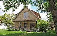
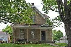
| 2 |
George and Susan Guiberson Armstrong House |
Upload image |
000000001987-09-29-0000September 29, 1987
(#87001668) |
2½ miles north of Winterset on G4R
41°23′18″N 93°58′26″W / 41.388333°N 93.973889°W / 41.388333; -93.973889 (George and Susan Guiberson Armstrong House) |
Winterset |
|
| 3 |
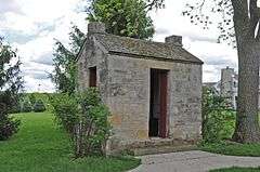
C.D. and Eliza Heath Bevington Privy |
|
000000001987-09-29-0000September 29, 1987
(#87001669) |
805 S. 2nd Ave.
41°19′40″N 94°00′53″W / 41.327778°N 94.014722°W / 41.327778; -94.014722 (C.D. and Eliza Heath Bevington Privy) |
Winterset |
|
| 4 |
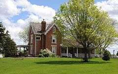
C.D. Bevington House and Stone Barn |
|
000000001976-12-12-0000December 12, 1976
(#76000785) |
805 S. 2nd Ave.
41°19′40″N 94°00′54″W / 41.327778°N 94.015°W / 41.327778; -94.015 (C.D. Bevington House and Stone Barn) |
Winterset |
|
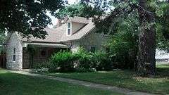
| 5 |
Seymour Church House |
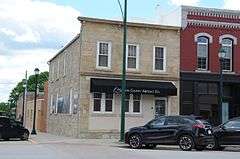
Upload image |
000000001987-09-29-0000September 29, 1987
(#87001683) |
U.S. Route 169
41°24′08″N 94°02′25″W / 41.402222°N 94.040278°W / 41.402222; -94.040278 (Seymour Church House) |
Winterset |
|
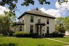
| 6 |
W.J. and Nettie J. Cornell House |
|
000000001991-01-11-0000January 11, 1991
(#90002132) |
602 W. Court Ave.
41°20′03″N 94°01′15″W / 41.334167°N 94.020833°W / 41.334167; -94.020833 (W.J. and Nettie J. Cornell House) |
Winterset |
|
| 7 |
J.D. Craven Women's Relief Corps Hall |
Upload image |
000000001984-01-19-0000January 19, 1984
(#84001274) |
South St.
41°12′50″N 94°11′07″W / 41.213889°N 94.185139°W / 41.213889; -94.185139 (J.D. Craven Women's Relief Corps Hall) |
Macksburg |
|
| 8 |
Cunningham Bridge |
Upload image |
000000001998-05-15-0000May 15, 1998
(#98000509) |
Upland Trail over the North River
41°24′06″N 93°51′40″W / 41.401667°N 93.861111°W / 41.401667; -93.861111 (Cunningham Bridge) |
Bevington |
|
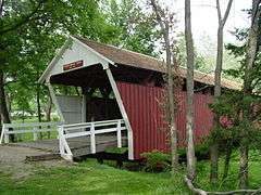
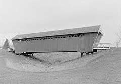
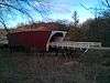
| 9 |
Cutler-Donahoe Covered Bridge |
|
000000001976-10-08-0000October 8, 1976
(#76000787) |
Winterset City Park
41°19′52″N 94°00′31″W / 41.331111°N 94.008611°W / 41.331111; -94.008611 (Cutler-Donahoe Covered Bridge) |
Winterset |
|
| 10 |
John and Amanda Bigler Drake House |
Upload image |
000000001987-09-29-0000September 29, 1987
(#87001670) |
11 miles west of Winterset on Iowa Highway 92
41°18′57″N 94°13′22″W / 41.315833°N 94.222778°W / 41.315833; -94.222778 (John and Amanda Bigler Drake House) |
Winterset |
|
| 11 |
Duff Barn |
Upload image |
000000001993-03-18-0000March 18, 1993
(#87001672) |
1½ miles north of Winterset on U.S. Route 169
41°22′03″N 94°00′53″W / 41.3675°N 94.014722°W / 41.3675; -94.014722 (Duff Barn) |
Winterset |
|
| 12 |
John M. Duncan House |
Upload image |
000000001987-09-29-0000September 29, 1987
(#87001673) |
½ mile south of Winterset on County Road P69
41°19′12″N 94°01′00″W / 41.32°N 94.016667°W / 41.32; -94.016667 (John M. Duncan House) |
Winterset |
|
| 13 |
Earlham Public School |
|
000000001982-06-02-0000June 2, 1982
(#82002631) |
809 Main St.
41°29′31″N 94°07′16″W / 41.491944°N 94.121111°W / 41.491944; -94.121111 (Earlham Public School) |
Earlham |
|
| 14 |
John and Elizabeth McMurn Early House |
Upload image |
000000001993-03-18-0000March 18, 1993
(#87001653) |
1 mile south of County Road G31 between County Roads P53 and P57
41°23′21″N 94°09′27″W / 41.389167°N 94.1575°W / 41.389167; -94.1575 (John and Elizabeth McMurn Early House) |
Earlham |
|
| 15 |
Henry and Elizabeth Adkinson Evans House |
Upload image |
000000001987-09-29-0000September 29, 1987
(#87001674) |
½ mile east of U.S. Route 169 on County Road G50
41°18′42″N 93°59′33″W / 41.311667°N 93.9925°W / 41.311667; -93.9925 (Henry and Elizabeth Adkinson Evans House) |
Winterset |
|
| 16 |
W.T. Ford House |
Upload image |
000000001987-09-29-0000September 29, 1987
(#87001654) |
2½ miles south of Earlham on County Road P57
41°27′13″N 94°08′06″W / 41.453611°N 94.135°W / 41.453611; -94.135 (W.T. Ford House) |
Earlham |
|
| 17 |
Guiberson House |
|
000000001979-07-10-0000July 10, 1979
(#79003697) |
302 S. 4th Ave.
41°19′56″N 94°01′06″W / 41.332361°N 94.018333°W / 41.332361; -94.018333 (Guiberson House) |
Winterset |
|
| 18 |
Daniel and Nancy Swaford Henderson House |
Upload image |
000000001987-09-29-0000September 29, 1987
(#87001655) |
8 miles south of Earlham on County Road P57
41°22′37″N 94°07′55″W / 41.376944°N 94.131944°W / 41.376944; -94.131944 (Daniel and Nancy Swaford Henderson House) |
Earlham |
|
| 19 |
Hogback Covered Bridge |
|
000000001976-08-28-0000August 28, 1976
(#76000788) |
4 miles north of Winterset
41°23′09″N 94°03′00″W / 41.385833°N 94.05°W / 41.385833; -94.05 (Hogback Covered Bridge) |
Winterset |
|
| 20 |
Holliwell Covered Bridge |
|
000000001976-08-28-0000August 28, 1976
(#76000789) |
4 miles southeast of Winterset
41°19′21″N 93°57′33″W / 41.3225°N 93.959167°W / 41.3225; -93.959167 (Holliwell Covered Bridge) |
Winterset |
|
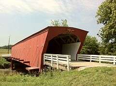
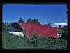
| 21 |
John S. and Elizabeth Beem Holmes Barn |
Upload image |
000000001987-09-29-0000September 29, 1987
(#87001665) |
County Road G50
41°17′00″N 93°57′14″W / 41.283333°N 93.953889°W / 41.283333; -93.953889 (John S. and Elizabeth Beem Holmes Barn) |
St. Charles |
|
| 22 |
Emily Hornback House |
|
000000001987-09-29-0000September 29, 1987
(#87001687) |
605 N. 1st St.
41°20′22″N 94°00′46″W / 41.339444°N 94.012778°W / 41.339444; -94.012778 (Emily Hornback House) |
Winterset |
|
| 23 |
Imes Covered Bridge |
|
000000001979-02-09-0000February 9, 1979
(#76000784) |
Iowa Highway 251
41°17′21″N 93°48′03″W / 41.289167°N 93.800833°W / 41.289167; -93.800833 (Imes Covered Bridge) |
St. Charles |
|
| 24 |
John Andrew and Sara Macumber Ice House |
Upload image |
000000001993-03-18-0000March 18, 1993
(#87001675) |
On County Road G53 1½ miles east of its junction with County Road P69
41°15′04″N 94°03′56″W / 41.251111°N 94.065556°W / 41.251111; -94.065556 (John Andrew and Sara Macumber Ice House) |
Winterset |
|
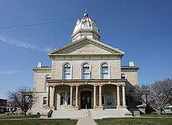
| 25 |
Madison County Courthouse |
|
000000001976-08-13-0000August 13, 1976
(#76000790) |
City Sq.
41°20′06″N 94°00′50″W / 41.335°N 94.013889°W / 41.335; -94.013889 (Madison County Courthouse) |
Winterset |
|
| 26 |
McDonald House |
Upload image |
000000001993-03-18-0000March 18, 1993
(#87001676) |
3½ miles west of Winterset off Iowa Highway 92
41°21′32″N 94°05′31″W / 41.358889°N 94.091944°W / 41.358889; -94.091944 (McDonald House) |
Winterset |
|
| 27 |
Peter and Isabelle McCulloch McQuie Milkhouse |
Upload image |
000000001987-09-29-0000September 29, 1987
(#87001656) |
Southwest of Earlham
41°25′51″N 94°09′34″W / 41.430833°N 94.159444°W / 41.430833; -94.159444 (Peter and Isabelle McCulloch McQuie Milkhouse) |
Earlham |
|
| 28 |
Miller Bridge |
Upload image |
000000001998-05-15-0000May 15, 1998
(#98000508) |
McBride Trail over an unnamed stream
41°24′45″N 93°56′34″W / 41.4125°N 93.942778°W / 41.4125; -93.942778 (Miller Bridge) |
Winterset |
|
| 29 |
Morgan Bridge |
Upload image |
000000001998-05-15-0000May 15, 1998
(#98000507) |
Maple Lane over a branch of Clanton Creek
41°10′16″N 93°55′55″W / 41.171111°N 93.931944°W / 41.171111; -93.931944 (Morgan Bridge) |
Old Peru |
|
| 30 |
William Anzi Nichols House |
Upload image |
000000001987-09-29-0000September 29, 1987
(#87001677) |
1 mile east of Winterset on Iowa Highway 92
41°20′42″N 93°59′57″W / 41.345°N 93.999167°W / 41.345; -93.999167 (William Anzi Nichols House) |
Winterset |
|
| 31 |
North River Stone Schoolhouse |
Upload image |
000000001977-04-11-0000April 11, 1977
(#77000537) |
North of Winterset off U.S. Route 169
41°24′10″N 94°02′32″W / 41.402778°N 94.042222°W / 41.402778; -94.042222 (North River Stone Schoolhouse) |
Winterset |
|
| 32 |
William Ogburn House |
Upload image |
000000001987-09-29-0000September 29, 1987
(#87001660) |
1½ miles north of East Peru
41°15′03″N 93°55′19″W / 41.250833°N 93.921944°W / 41.250833; -93.921944 (William Ogburn House) |
East Peru |
|
| 33 |
Hogan and Martha A. Runkle Queen House |
Upload image |
000000001987-09-29-0000September 29, 1987
(#87001667) |
5 miles west of St. Charles on County Road G50
41°18′05″N 93°53′51″W / 41.301389°N 93.8975°W / 41.301389; -93.8975 (Hogan and Martha A. Runkle Queen House) |
St. Charles |
|
| 34 |
Roseman Covered Bridge |
|
000000001976-09-01-0000September 1, 1976
(#76000792) |
West of Winterset off Iowa Highway 92
41°17′31″N 94°09′05″W / 41.291944°N 94.151389°W / 41.291944; -94.151389 (Roseman Covered Bridge) |
Winterset |
|
| 35 |
St. Patrick's Church |
Upload image |
000000001978-12-12-0000December 12, 1978
(#78001245) |
Northwest of Cumming
41°25′39″N 93°47′34″W / 41.4275°N 93.792778°W / 41.4275; -93.792778 (St. Patrick's Church) |
Cumming |
|
| 36 |
John and Fredericka Meyer Schnellbacher House |
Upload image |
000000001987-09-29-0000September 29, 1987
(#87001678) |
On County Road G47 1½ miles east of its junction with County Road P53
41°17′26″N 94°08′40″W / 41.290556°N 94.144444°W / 41.290556; -94.144444 (John and Fredericka Meyer Schnellbacher House) |
Winterset |
|
| 37 |
Nicholas Schoenenberger House and Barn |
Upload image |
000000001984-07-12-0000July 12, 1984
(#84001275) |
Off Iowa Highway 169
41°13′17″N 93°59′58″W / 41.221389°N 93.999444°W / 41.221389; -93.999444 (Nicholas Schoenenberger House and Barn) |
Winterset |
|
| 38 |
William and Mary (Messersmith) Seerley Barn and Milkhouse-Smokehouse |
Upload image |
000000002009-08-20-0000August 20, 2009
(#09000621) |
1840 137th Lane
41°26′45″N 94°05′24″W / 41.445833°N 94.09°W / 41.445833; -94.09 (William and Mary (Messersmith) Seerley Barn and Milkhouse-Smokehouse) |
Earlham |
|
| 39 |
William R. and Martha Foster Shriver House |
|
000000001993-03-18-0000March 18, 1993
(#87001689) |
616 E. Court Ave.
41°20′03″N 94°00′25″W / 41.334167°N 94.006944°W / 41.334167; -94.006944 (William R. and Martha Foster Shriver House) |
Winterset |
|
| 40 |
Hiram C. Smith House |
Upload image |
000000001987-09-29-0000September 29, 1987
(#87001684) |
6 miles west of Winterset on Iowa Highway 92
41°19′48″N 94°08′34″W / 41.33°N 94.142639°W / 41.33; -94.142639 (Hiram C. Smith House) |
Winterset |
|
| 41 |
Hiram C. Smith Milking Shed |
Upload image |
000000001987-09-29-0000September 29, 1987
(#87001686) |
6 miles west of Winterset on Iowa Highway 92
41°19′47″N 94°08′32″W / 41.329722°N 94.142222°W / 41.329722; -94.142222 (Hiram C. Smith Milking Shed) |
Winterset |
|
| 42 |
Sprague, Brown, and Knowlton Store |
Upload image |
000000001987-09-29-0000September 29, 1987
(#87001690) |
1st and Court
41°20′03″N 94°00′52″W / 41.334167°N 94.014444°W / 41.334167; -94.014444 (Sprague, Brown, and Knowlton Store) |
Winterset |
|
| 43 |
Miller Richard and Mary Fisher Tidrick House |
|
000000001993-03-18-0000March 18, 1993
(#93000126) |
122 S. 4th Ave.
41°20′01″N 94°01′06″W / 41.333611°N 94.018333°W / 41.333611; -94.018333 (Miller Richard and Mary Fisher Tidrick House) |
Winterset |
|
| 44 |
J.G. and Elizabeth S. Vawter House |
Upload image |
000000001987-09-29-0000September 29, 1987
(#87001692) |
223 S. 1st St.
41°19′58″N 94°00′46″W / 41.332778°N 94.012778°W / 41.332778; -94.012778 (J.G. and Elizabeth S. Vawter House) |
Winterset |
|
| 45 |
Henry C. Wallace House |
|
000000001985-01-03-0000January 3, 1985
(#85000005) |
422 W. Jefferson
41°20′07″N 94°01′09″W / 41.335278°N 94.019167°W / 41.335278; -94.019167 (Henry C. Wallace House) |
Winterset |
|
| 46 |
White, Munger and Company Store |
|
000000001987-09-29-0000September 29, 1987
(#87001693) |
102 W. Court
41°20′03″N 94°00′53″W / 41.334167°N 94.014722°W / 41.334167; -94.014722 (White, Munger and Company Store) |
Winterset |
|
| 47 |
Seth and Elizabeth Wilson House |
Upload image |
000000001987-09-29-0000September 29, 1987
(#87001659) |
1¾ miles east of County Road P57 on County Road G14
41°28′10″N 94°05′39″W / 41.469444°N 94.094167°W / 41.469444; -94.094167 (Seth and Elizabeth Wilson House) |
Earlham |
|
| 48 |
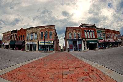
Winterset Courthouse Square Commercial Historic District |
|
000000002015-12-22-0000December 22, 2015
(#15000915) |
Roughly bounded by Green & 2nd Sts., 2nd Ave. & alley S. of Court Ave.
41°20′05″N 94°00′51″W / 41.334835°N 94.014156°W / 41.334835; -94.014156 (Winterset Courthouse Square Commercial Historic District) |
Winterset |
|