National Register of Historic Places listings in Montgomery County, Iowa
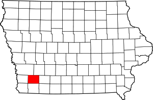
Location of Montgomery County in Iowa
This is a list of the National Register of Historic Places listings in Montgomery County, Iowa.
This is intended to be a complete list of the properties and districts on the National Register of Historic Places in Montgomery County, Iowa, United States. Latitude and longitude coordinates are provided for many National Register properties and districts; these locations may be seen together in a map.[1]
There are 17 properties and districts listed on the National Register in the county, and one former listing.
- This National Park Service list is complete through NPS recent listings posted December 16, 2016.[2]
Current listings
| [3] |
Name on the Register[4] |
Image |
Date listed[5] |
Location |
City or town |
Description |
|---|
| 1 |
Chautauqua Park |
Upload image |
000000001972-05-19-0000May 19, 1972
(#72000479) |
Oak St.
41°01′00″N 95°13′17″W / 41.016554°N 95.221300°W / 41.016554; -95.221300 (Chautauqua Park) |
Red Oak |
|
| 2 |
Chicago, Burlington Northern and Quincy Depot |
Upload image |
000000001999-04-29-0000April 29, 1999
(#99000489) |
305 S. 2nd St.
41°00′08″N 95°13′51″W / 41.002222°N 95.230833°W / 41.002222; -95.230833 (Chicago, Burlington Northern and Quincy Depot) |
Red Oak |
|
| 3 |
William and Amanda J. Ellis Farmstead Historic District |
Upload image |
000000002015-10-23-0000October 23, 2015
(#15000752) |
1134 I Ave.
41°08′26″N 95°12′50″W / 41.1405°N 95.214°W / 41.1405; -95.214 (William and Amanda J. Ellis Farmstead Historic District) |
Elliott vicinity |
|
| 4 |
Grant Commercial Historic District |
Upload image |
000000002002-09-12-0000September 12, 2002
(#02001031) |
Parts of 2nd St. and U Ave.
41°08′31″N 94°59′03″W / 41.141944°N 94.984167°W / 41.141944; -94.984167 (Grant Commercial Historic District) |
Grant |
|
| 5 |
Alfred Hebard House |
Upload image |
000000001984-04-12-0000April 12, 1984
(#84001290) |
700 8th St.
41°00′39″N 95°13′22″W / 41.010833°N 95.222778°W / 41.010833; -95.222778 (Alfred Hebard House) |
Red Oak |
|
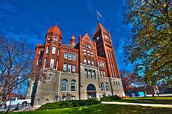
| 6 |
Montgomery County Courthouse |
|
000000001981-07-02-0000July 2, 1981
(#81000259) |
Coolbaugh and 2nd Sts.
41°00′34″N 95°13′50″W / 41.009444°N 95.230556°W / 41.009444; -95.230556 (Montgomery County Courthouse) |
Red Oak |
|
| 7 |
Montgomery County Jail |
Upload image |
000000001992-12-18-0000December 18, 1992
(#92001661) |
100 W. Coolbaugh St.
41°00′31″N 95°13′55″W / 41.008611°N 95.231944°W / 41.008611; -95.231944 (Montgomery County Jail) |
Red Oak |
|
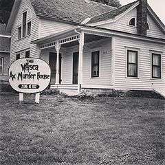
| 8 |
Josiah B. and Sara Moore House |
|
000000001997-12-01-0000December 1, 1997
(#97001471) |
508 E. 2nd St.
40°55′50″N 94°58′23″W / 40.930556°N 94.973056°W / 40.930556; -94.973056 (Josiah B. and Sara Moore House) |
Villisca |
|
| 9 |
Thos. D. Murphy Co. Factory and Power Plant |
Upload image |
000000002008-05-19-0000May 19, 2008
(#08000505) |
110 S. 2nd St.
41°00′17″N 95°13′49″W / 41.00466°N 95.23034°W / 41.00466; -95.23034 (Thos. D. Murphy Co. Factory and Power Plant) |
Red Oak |
|
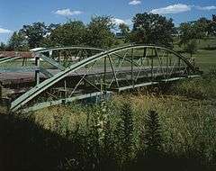
| 10 |
Nodaway River Bridge |
|
000000001998-05-15-0000May 15, 1998
(#98000494) |
Pedestrian path in Pilot Grove County Park
41°08′52″N 95°02′31″W / 41.147778°N 95.041944°W / 41.147778; -95.041944 (Nodaway River Bridge) |
Grant |
|
| 11 |
Edmund B. Osborne House |
Upload image |
000000001997-10-30-0000October 30, 1997
(#97001287) |
1020 Boundary St.
41°00′48″N 95°13′13″W / 41.013333°N 95.220278°W / 41.013333; -95.220278 (Edmund B. Osborne House) |
Red Oak |
|
| 12 |
Red Oak Firehouse and City Jail |
Upload image |
000000002006-01-11-0000January 11, 2006
(#05001508) |
318 E. Washington Ave.
41°00′28″N 95°13′42″W / 41.007776°N 95.228255°W / 41.007776; -95.228255 (Red Oak Firehouse and City Jail) |
Red Oak |
|
| 13 |
Red Oak Public Library |
Upload image |
000000001983-05-23-0000May 23, 1983
(#83000394) |
2nd and Washington Sts.
41°05′31″N 95°14′50″W / 41.091944°N 95.247222°W / 41.091944; -95.247222 (Red Oak Public Library) |
Red Oak |
|
| 14 |
Round Barn, Pilot Grove Township |
Upload image |
000000001986-06-30-0000June 30, 1986
(#86001467) |
County Road H20
41°06′21″N 95°04′50″W / 41.105833°N 95.080556°W / 41.105833; -95.080556 (Round Barn, Pilot Grove Township) |
Pilot Grove Township |
|
| 15 |
Round Barn, Washington Township |
Upload image |
000000001986-06-30-0000June 30, 1986
(#86001466) |
U.S. Route 71
41°03′39″N 94°59′01″W / 41.060833°N 94.983611°W / 41.060833; -94.983611 (Round Barn, Washington Township) |
Washington Township |
|
| 16 |
Sciola Missionary Baptist Church |
Upload image |
000000001983-07-18-0000July 18, 1983
(#83000395) |
U.S. Route 71
41°02′03″N 94°59′09″W / 41.034167°N 94.985833°W / 41.034167; -94.985833 (Sciola Missionary Baptist Church) |
Sciola |
|
| 17 |
Villisca National Guard Armory |
Upload image |
000000002015-05-18-0000May 18, 2015
(#15000227) |
316 E. 3rd St.
40°55′47″N 94°58′35″W / 40.9298°N 94.9763°W / 40.9298; -94.9763 (Villisca National Guard Armory) |
Villisca |
|
| [3] |
Name on the Register |
Image |
Date listed | Date removed |
Location |
City or town |
Summary |
|---|
| 1 |
B. F. Runnels House |
Upload image |
000000001979-06-04-0000June 4, 1979
(#79000918) | 000000002000-03-15-0000March 15, 2000 |
Southwest of Red Oak
|
Red Oak vicinity |
|
See also
References
- ↑ The latitude and longitude information provided in this table was derived originally from the National Register Information System, which has been found to be fairly accurate for about 99% of listings. For about 1% of NRIS original coordinates, experience has shown that one or both coordinates are typos or otherwise extremely far off; some corrections may have been made. A more subtle problem causes many locations to be off by up to 150 yards, depending on location in the country: most NRIS coordinates were derived from tracing out latitude and longitudes off of USGS topographical quadrant maps created under the North American Datum of 1927, which differs from the current, highly accurate WGS84 GPS system used by most on-line maps. Chicago is about right, but NRIS longitudes in Washington are higher by about 4.5 seconds, and are lower by about 2.0 seconds in Maine. Latitudes differ by about 1.0 second in Florida. Some locations in this table may have been corrected to current GPS standards.
- ↑ "National Register of Historic Places: Weekly List Actions". National Park Service, United States Department of the Interior. Retrieved on December 16, 2016.
- 1 2 Numbers represent an ordering by significant words. Various colorings, defined here, differentiate National Historic Landmarks and historic districts from other NRHP buildings, structures, sites or objects.
- ↑ National Park Service (2008-04-24). "National Register Information System". National Register of Historic Places. National Park Service.
- ↑ The eight-digit number below each date is the number assigned to each location in the National Register Information System database, which can be viewed by clicking the number.
|
|---|
|
| Topics | |
|---|
|
| Lists by states | |
|---|
|
| Lists by insular areas | |
|---|
|
| Lists by associated states | |
|---|
|
| Other areas | |
|---|
|
-
 Portal Portal
-
 WikiProject WikiProject
|