National Register of Historic Places listings in Boone County, Iowa
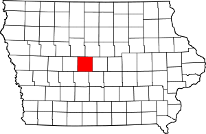
Location of Boone County in Iowa
This is a list of the National Register of Historic Places listings in Boone County, Iowa.
This is intended to be a complete list of the properties and districts on the National Register of Historic Places in Boone County, Iowa, United States. Latitude and longitude coordinates are provided for many National Register properties and districts; these locations may be seen together in a map.[1]
There are 18 properties listed on the National Register in the county.
- This National Park Service list is complete through NPS recent listings posted December 16, 2016.[2]
| [3] |
Name on the Register[4] |
Image |
Date listed[5] |
Location |
City or town |
Description |
|---|
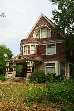
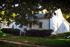
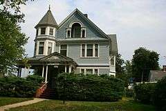
| 1 |
Alonzo J. and Flora Barkley House |
|
000000001995-07-21-0000July 21, 1995
(#95000857) |
326 Boone St.
42°03′33″N 93°52′54″W / 42.059167°N 93.881667°W / 42.059167; -93.881667 (Alonzo J. and Flora Barkley House) |
Boone |
|
| 2 |
Beaver Creek Bridge |
|
000000001998-06-25-0000June 25, 1998
(#98000762) |
210th St. over Beaver Creek
42°02′57″N 94°08′31″W / 42.049167°N 94.141944°W / 42.049167; -94.141944 (Beaver Creek Bridge) |
Ogden |
|
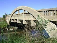
| 3 |
Big Creek Bridge |
Upload image |
000000001998-06-25-0000June 25, 1998
(#98000766) |
2110 300th St. over Big Creek
41°55′18″N 93°45′23″W / 41.921618°N 93.756514°W / 41.921618; -93.756514 (Big Creek Bridge) |
Madrid |
|
| 4 |
Big Creek Bridge 2 |
Upload image |
000000001998-06-25-0000June 25, 1998
(#98000767) |
2130 320th St. over Big Creek
41°53′33″N 93°45′02″W / 41.8925°N 93.750556°W / 41.8925; -93.750556 (Big Creek Bridge 2) |
Madrid |
|
| 5 |
Boone Bridge |
Upload image |
000000001998-06-25-0000June 25, 1998
(#98000761) |
Old U.S. Route 30 over the Des Moines River
42°02′32″N 93°56′00″W / 42.042222°N 93.933333°W / 42.042222; -93.933333 (Boone Bridge) |
Boone |
|
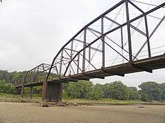
| 6 |
Boone Bridge 2 |
|
000000001998-06-25-0000June 25, 1998
(#98000765) |
1000 200th St. over the Des Moines River
42°03′47″N 93°58′13″W / 42.063056°N 93.970278°W / 42.063056; -93.970278 (Boone Bridge 2) |
Boone |
|
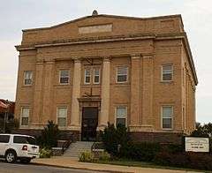
| 7 |
Boone County Courthouse |
|
000000001981-07-02-0000July 2, 1981
(#81000226) |
N. State and W. 2nd Sts.
42°03′32″N 93°54′21″W / 42.058889°N 93.905833°W / 42.058889; -93.905833 (Boone County Courthouse) |
Boone |
|
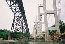
| 8 |
Boone Viaduct |
|
000000001978-11-17-0000November 17, 1978
(#78001207) |
West of Boone
42°03′33″N 93°58′12″W / 42.059167°N 93.97°W / 42.059167; -93.97 (Boone Viaduct) |
Boone |
|
| 9 |
Carl and Ulrika Dalander Cassel House |
|
000000001982-04-12-0000April 12, 1982
(#82002609) |
415 W. 2nd St.
41°52′32″N 93°49′31″W / 41.875556°N 93.825278°W / 41.875556; -93.825278 (Carl and Ulrika Dalander Cassel House) |
Madrid |
|
| 10 |
Champlin Memorial Masonic Temple |
|
000000001990-12-20-0000December 20, 1990
(#90001853) |
602 Story St.
42°03′44″N 93°52′45″W / 42.062222°N 93.879167°W / 42.062222; -93.879167 (Champlin Memorial Masonic Temple) |
Boone |
|
| 11 |
Ericson Public Library |
|
000000001983-05-23-0000May 23, 1983
(#83000344) |
702 Greene St.
42°03′47″N 93°52′58″W / 42.063056°N 93.882778°W / 42.063056; -93.882778 (Ericson Public Library) |
Boone |
|
| 12 |
First National Bank |
|
000000001989-06-28-0000June 28, 1989
(#88003232) |
8th and Story Sts.
42°03′47″N 93°52′58″W / 42.063056°N 93.882778°W / 42.063056; -93.882778 (First National Bank) |
Boone |
|
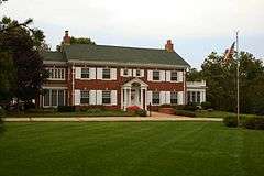
| 13 |
John H. Herman House |
|
000000001989-06-28-0000June 28, 1989
(#88003233) |
711 S. Story St.
42°02′56″N 93°52′50″W / 42.048889°N 93.880556°W / 42.048889; -93.880556 (John H. Herman House) |
Boone |
|
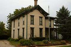
| 14 |
Perrigo-Holmes House |
|
000000001994-09-08-0000September 8, 1994
(#94001102) |
721 Carroll St.
42°03′48″N 93°53′07″W / 42.063333°N 93.885278°W / 42.063333; -93.885278 (Perrigo-Holmes House) |
Boone |
|
| 15 |
J.H. Riekenberg House |
|
000000001988-04-11-0000April 11, 1988
(#87002017) |
310 N. Tama St.
42°03′32″N 93°52′34″W / 42.058889°N 93.876111°W / 42.058889; -93.876111 (J.H. Riekenberg House) |
Boone |
|
| 16 |
Squaw Creek Bridge |
Upload image |
000000001998-06-25-0000June 25, 1998
(#98000763) |
120th St. and V Ave. over Squaw Creek
42°10′51″N 93°45′28″W / 42.180833°N 93.757778°W / 42.180833; -93.757778 (Squaw Creek Bridge) |
Ridgeport |
|
| 17 |
Squaw Creek Bridge 2 |
Upload image |
000000001998-06-25-0000June 25, 1998
(#98000764) |
110th St. and V Ave. over Squaw Creek
42°11′44″N 93°46′31″W / 42.195556°N 93.775278°W / 42.195556; -93.775278 (Squaw Creek Bridge 2) |
Ridgeport |
|
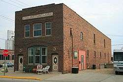
| 18 |
Stoll Building Works |
|
000000001997-05-02-0000May 2, 1997
(#97000390) |
824 Allen St.
42°03′53″N 93°52′43″W / 42.064719°N 93.878612°W / 42.064719; -93.878612 (Stoll Building Works) |
Boone |
|
| [3] |
Name on the Register |
Image |
Date listed | Date removed |
Location |
City or town |
Summary |
|---|
| 1 |
Finnegan Flats |
Upload image |
000000001977-09-20-0000September 20, 1977
(#77000499) | Unknown |
710-718 7th St.
|
Boone |
|
See also
References
- ↑ The latitude and longitude information provided in this table was derived originally from the National Register Information System, which has been found to be fairly accurate for about 99% of listings. For about 1% of NRIS original coordinates, experience has shown that one or both coordinates are typos or otherwise extremely far off; some corrections may have been made. A more subtle problem causes many locations to be off by up to 150 yards, depending on location in the country: most NRIS coordinates were derived from tracing out latitude and longitudes off of USGS topographical quadrant maps created under the North American Datum of 1927, which differs from the current, highly accurate WGS84 GPS system used by most on-line maps. Chicago is about right, but NRIS longitudes in Washington are higher by about 4.5 seconds, and are lower by about 2.0 seconds in Maine. Latitudes differ by about 1.0 second in Florida. Some locations in this table may have been corrected to current GPS standards.
- ↑ "National Register of Historic Places: Weekly List Actions". National Park Service, United States Department of the Interior. Retrieved on December 16, 2016.
- 1 2 Numbers represent an ordering by significant words. Various colorings, defined here, differentiate National Historic Landmarks and historic districts from other NRHP buildings, structures, sites or objects.
- ↑ National Park Service (2008-04-24). "National Register Information System". National Register of Historic Places. National Park Service.
- ↑ The eight-digit number below each date is the number assigned to each location in the National Register Information System database, which can be viewed by clicking the number.
|
|---|
|
| Topics | |
|---|
|
| Lists by states | |
|---|
|
| Lists by insular areas | |
|---|
|
| Lists by associated states | |
|---|
|
| Other areas | |
|---|
|
-
 Portal Portal
-
 WikiProject WikiProject
|