National Register of Historic Places listings in Buchanan County, Iowa
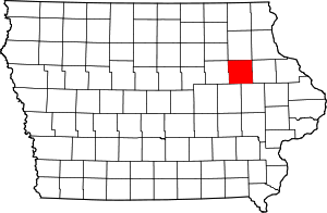
Location of Buchanan County in Iowa
This is a list of the National Register of Historic Places listings in Buchanan County, Iowa.
This is intended to be a complete list of the properties and districts on the National Register of Historic Places in Buchanan County, Iowa, United States. Latitude and longitude coordinates are provided for many National Register properties and districts; these locations may be seen together in a map.[1]
There are 19 properties and districts listed on the National Register in the county.
- This National Park Service list is complete through NPS recent listings posted December 16, 2016.[2]
Current listings
| [3] |
Name on the Register[4] |
Image |
Date listed[5] |
Location |
City or town |
Description |
|---|
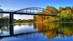
| 1 |
280th Street Bridge |
Upload image |
000000001998-06-25-0000June 25, 1998
(#98000756) |
280th St. over an unnamed stream
42°23′06″N 91°56′34″W / 42.385°N 91.942778°W / 42.385; -91.942778 (280th Street Bridge) |
Independence |
|
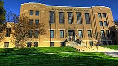
| 2 |
Buchanan County Court House |
|
000000002003-08-28-0000August 28, 2003
(#03000820) |
216 5th Ave.
42°28′14″N 91°53′21″W / 42.470556°N 91.889167°W / 42.470556; -91.889167 (Buchanan County Court House) |
Independence |
PWA Moderne-style courthouse built in 1940.
|
| 3 |
Fisher-Plane Commercial Building |
Upload image |
000000001997-03-08-0000March 8, 1997
(#97000212) |
119 and 121 1st St., E.
42°28′07″N 91°53′35″W / 42.468611°N 91.893056°W / 42.468611; -91.893056 (Fisher-Plane Commercial Building) |
Independence |
|
| 4 |
Mathias C. and Eva B. Crowell Fuhrman Farm |
Upload image |
000000001998-05-01-0000May 1, 1998
(#97000213) |
1780 185th St.
42°30′47″N 91°55′44″W / 42.513056°N 91.928889°W / 42.513056; -91.928889 (Mathias C. and Eva B. Crowell Fuhrman Farm) |
Independence |
|
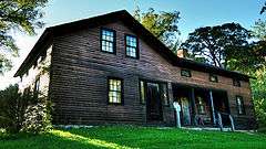
| 5 |
Captain Daniel S. and Fannie L. (Brooks) Lee House |
|
000000002010-01-07-0000January 7, 2010
(#09001203) |
803 1st St. East
42°28′08″N 91°53′06″W / 42.468797°N 91.88505°W / 42.468797; -91.88505 (Captain Daniel S. and Fannie L. (Brooks) Lee House) |
Independence |
|
| 6 |
Maas Commercial Building |
Upload image |
000000001998-08-14-0000August 14, 1998
(#98001047) |
209 1st St., E.
42°28′01″N 91°53′35″W / 42.466944°N 91.893056°W / 42.466944; -91.893056 (Maas Commercial Building) |
Independence |
|
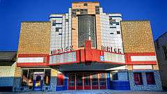
| 7 |
Malek Theatre |
|
000000002009-05-21-0000May 21, 2009
(#09000329) |
116 2nd Ave. NE
42°28′10″N 91°53′36″W / 42.4694°N 91.8932°W / 42.4694; -91.8932 (Malek Theatre) |
Independence |
|
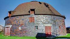
| 8 |
Erza McKenzie Round Barn |
|
000000001986-06-30-0000June 30, 1986
(#86001419) |
Off Iowa Highway 150
42°36′26″N 91°56′07″W / 42.607222°N 91.935278°W / 42.607222; -91.935278 (Erza McKenzie Round Barn) |
Hazleton |
|
| 9 |
Munson Building |
Upload image |
000000001976-11-21-0000November 21, 1976
(#76000736) |
210 2nd St., NE.
42°28′14″N 91°53′44″W / 42.470556°N 91.895556°W / 42.470556; -91.895556 (Munson Building) |
Independence |
|
| 10 |
Robert R. and Julia L. Plane House |
Upload image |
000000001999-08-27-0000August 27, 1999
(#99001030) |
301 3rd Ave., SE.
42°27′58″N 91°53′31″W / 42.466111°N 91.891944°W / 42.466111; -91.891944 (Robert R. and Julia L. Plane House) |
Independence |
|
| 11 |
Eliphalet W. and Catherine E. Jaquish Purdy House |
Upload image |
000000001996-03-07-0000March 7, 1996
(#96000237) |
215 3rd Ave., SW.
42°28′01″N 91°53′48″W / 42.466944°N 91.896667°W / 42.466944; -91.896667 (Eliphalet W. and Catherine E. Jaquish Purdy House) |
Independence |
|
| 12 |
Richardson-Jakway House |
|
000000001985-06-27-0000June 27, 1985
(#85001382) |
Rural Route #1
42°35′04″N 91°43′26″W / 42.584444°N 91.723889°W / 42.584444; -91.723889 (Richardson-Jakway House) |
Aurora |
|
| 13 |
Dr. Judd C. and Margaret S. Clarke Shellito House |
Upload image |
000000001997-01-16-0000January 16, 1997
(#96001588) |
310 5th Ave., SE.
42°27′58″N 91°53′20″W / 42.466111°N 91.888889°W / 42.466111; -91.888889 (Dr. Judd C. and Margaret S. Clarke Shellito House) |
Independence |
|
| 14 |
State Savings Bank |
Upload image |
000000001999-08-27-0000August 27, 1999
(#99001031) |
103 N. Water St.
42°23′40″N 91°45′41″W / 42.394444°N 91.761389°W / 42.394444; -91.761389 (State Savings Bank) |
Quasqueton |
|
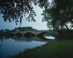
| 15 |
Taylor's Ford Bridge |
|
000000001998-06-25-0000June 25, 1998
(#98000755) |
Nolen Ave. over the Wapsipinicon River
42°23′58″N 91°48′46″W / 42.399444°N 91.812778°W / 42.399444; -91.812778 (Taylor's Ford Bridge) |
Independence |
|
| 16 |
Lowell E. Walter House |
|
000000001983-03-02-0000March 2, 1983
(#83000345) |
Off Quasqueton Diagonal Boulevard northwest of Quasqueton
42°24′31″N 91°46′11″W / 42.408611°N 91.769722°W / 42.408611; -91.769722 (Lowell E. Walter House) |
Quasqueton |
Preserved within Cedar Rock State Park.
|
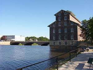
| 17 |
Wapsipinicon Mill |
|
000000001975-04-21-0000April 21, 1975
(#75000678) |
100 1st St., W.
42°28′08″N 91°53′53″W / 42.468889°N 91.898056°W / 42.468889; -91.898056 (Wapsipinicon Mill) |
Independence |
|
| 18 |
Wapsipinicon River Bridge |
|
000000001998-06-25-0000June 25, 1998
(#98000758) |
Iowa Highway 150 over the Wapsipinicon River
42°27′31″N 91°53′27″W / 42.458611°N 91.890833°W / 42.458611; -91.890833 (Wapsipinicon River Bridge) |
Independence |
|
| 19 |
Weins Commercial Building |
Upload image |
000000001997-01-16-0000January 16, 1997
(#96001585) |
129-131 2nd Ave., NE.
42°28′11″N 91°53′37″W / 42.469722°N 91.893611°W / 42.469722; -91.893611 (Weins Commercial Building) |
Independence |
|
| [3] |
Name on the Register |
Image |
Date listed | Date removed |
Location |
City or town |
Summary |
|---|
| 1 |
Otter Creek Bridge |
Upload image |
000000001998-06-25-0000June 25, 1998
(#98000757) | 000000002004-06-22-0000June 22, 2004 |
105th St. over Otter Cr.
|
Hazleton vicinity |
Pratt pony truss bridge built in 1870.
|
| 1 |
Otterville Bridge |
Upload image |
000000001998-06-25-0000June 25, 1998
(#98000759) | 000000002002-01-14-0000January 14, 2002 |
Bordner Dam Rd. over Wapsipinicon River
|
Independence vicinity |
|
See also
References
- ↑ The latitude and longitude information provided in this table was derived originally from the National Register Information System, which has been found to be fairly accurate for about 99% of listings. For about 1% of NRIS original coordinates, experience has shown that one or both coordinates are typos or otherwise extremely far off; some corrections may have been made. A more subtle problem causes many locations to be off by up to 150 yards, depending on location in the country: most NRIS coordinates were derived from tracing out latitude and longitudes off of USGS topographical quadrant maps created under the North American Datum of 1927, which differs from the current, highly accurate WGS84 GPS system used by most on-line maps. Chicago is about right, but NRIS longitudes in Washington are higher by about 4.5 seconds, and are lower by about 2.0 seconds in Maine. Latitudes differ by about 1.0 second in Florida. Some locations in this table may have been corrected to current GPS standards.
- ↑ "National Register of Historic Places: Weekly List Actions". National Park Service, United States Department of the Interior. Retrieved on December 16, 2016.
- 1 2 Numbers represent an ordering by significant words. Various colorings, defined here, differentiate National Historic Landmarks and historic districts from other NRHP buildings, structures, sites or objects.
- ↑ National Park Service (2008-04-24). "National Register Information System". National Register of Historic Places. National Park Service.
- ↑ The eight-digit number below each date is the number assigned to each location in the National Register Information System database, which can be viewed by clicking the number.
|
|---|
|
| Topics | |
|---|
|
| Lists by states | |
|---|
|
| Lists by insular areas | |
|---|
|
| Lists by associated states | |
|---|
|
| Other areas | |
|---|
|
-
 Portal Portal
-
 WikiProject WikiProject
|
_Lee_House.jpg)