| [3] |
Name on the Register |
Image |
Date listed[4] |
Location |
City or town |
Description |
|---|
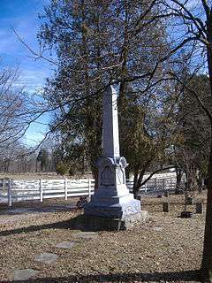
| 1 |
Ashbourne Farms |
|
000000002008-03-25-0000March 25, 2008
(#08000212) |
3800 Old Westport Rd.
38°27′03″N 85°25′22″W / 38.450833°N 85.422778°W / 38.450833; -85.422778 (Ashbourne Farms) |
La Grange |
|
| 2 |
Ashwood Avenue Historic District |
Upload image |
000000001989-08-07-0000August 7, 1989
(#89000951) |
Roughly Ash Ave. from La Grange Rd. to Elm Ave.
38°18′26″N 85°29′19″W / 38.307222°N 85.488611°W / 38.307222; -85.488611 (Ashwood Avenue Historic District) |
Pewee Valley |
|
| 3 |
John Leslie Bate House |
Upload image |
000000001987-01-08-0000January 8, 1987
(#87000144) |
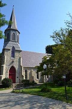
East of Buckeye Ln. off Kentucky Route 42
38°25′44″N 85°33′46″W / 38.428889°N 85.562778°W / 38.428889; -85.562778 (John Leslie Bate House) |
Goshen |
|
| 4 |
Bondurant-Hustin House |
Upload image |
000000001989-11-27-0000November 27, 1989
(#89001989) |
104 Castlewood Dr.
38°18′21″N 85°29′45″W / 38.305833°N 85.495833°W / 38.305833; -85.495833 (Bondurant-Hustin House) |
Pewee Valley |
|
| 5 |
Bradshaw-Duncan House |
Upload image |
000000002005-07-14-0000July 14, 2005
(#05000254) |
8502 Todds Point Rd.
38°18′12″N 85°26′03″W / 38.303333°N 85.434167°W / 38.303333; -85.434167 (Bradshaw-Duncan House) |
Crestwood |
|
| 6 |
Building at 301 La Grange Road |
Upload image |
000000001989-11-27-0000November 27, 1989
(#89001980) |
301 La Grange Rd.
38°18′38″N 85°29′14″W / 38.310556°N 85.487222°W / 38.310556; -85.487222 (Building at 301 La Grange Road) |
Pewee Valley |
|
| 7 |
Carpenter-Smith House |
Upload image |
000000001982-02-25-0000February 25, 1982
(#82002739) |
Covered Bridge Rd.
38°22′08″N 85°31′46″W / 38.368889°N 85.529444°W / 38.368889; -85.529444 (Carpenter-Smith House) |
Crestwood |
|
| 8 |
Central Avenue Historic District |
|
000000001989-08-07-0000August 7, 1989
(#89000950) |
Roughly Central Ave. from Peace Ln. to Mt. Mercy Dr.
38°18′40″N 85°29′35″W / 38.311111°N 85.493056°W / 38.311111; -85.493056 (Central Avenue Historic District) |
Pewee Valley |
|
| 9 |
Central La Grange Historic District |
|
000000001988-09-08-0000September 8, 1988
(#88001316) |
Primarily along Washington, Main, and Jefferson Sts., Kentucky Ave., and 1st through 6th Aves.
38°24′25″N 85°22′54″W / 38.406944°N 85.381667°W / 38.406944; -85.381667 (Central La Grange Historic District) |
La Grange |
|
| 10 |
Clifton |
Upload image |
000000001997-08-18-0000August 18, 1997
(#97000874) |
4801 Greenhaven Ln.
38°27′50″N 85°28′55″W / 38.463889°N 85.481944°W / 38.463889; -85.481944 (Clifton) |
Goshen |
|
| 11 |
Albert E. Clore House |
Upload image |
000000001983-05-26-0000May 26, 1983
(#83002842) |
6400 Clore Lane
38°19′58″N 85°30′04″W / 38.332778°N 85.501111°W / 38.332778; -85.501111 (Albert E. Clore House) |
Crestwood |
|
| 12 |
Confederate Memorial in Pewee Valley |
|
000000001997-07-17-0000July 17, 1997
(#97000673) |
Confederate Cemetery, junction of Maple Ave. and Old Floydsburg Rd.
38°18′11″N 85°28′32″W / 38.303056°N 85.475556°W / 38.303056; -85.475556 (Confederate Memorial in Pewee Valley) |
Pewee Valley |
|
| 13 |
Joseph H. Ellis House |
Upload image |
000000001989-11-27-0000November 27, 1989
(#89001988) |
320 Maple Ave.
38°18′20″N 85°28′46″W / 38.305556°N 85.479444°W / 38.305556; -85.479444 (Joseph H. Ellis House) |
Pewee Valley |
|
| 14 |
Forrester-Duvall House |
Upload image |
000000001989-11-27-0000November 27, 1989
(#89001987) |
115 Old Forest Rd.
38°18′12″N 85°29′12″W / 38.303333°N 85.486667°W / 38.303333; -85.486667 (Forrester-Duvall House) |
Pewee Valley |
|
| 15 |
D. W. Griffith House |
|
000000001976-06-03-0000June 3, 1976
(#76000935) |
206 N. 4th St.
38°24′30″N 85°23′02″W / 38.408333°N 85.383889°W / 38.408333; -85.383889 (D. W. Griffith House) |
La Grange |
|
| 16 |
Harrods Creek Baptist Church and Rev. William Kellar House |
Upload image |
000000001976-09-08-0000September 8, 1976
(#76000934) |
Northwest of Crestwood on Old Brownsboro Rd.
38°21′32″N 85°30′39″W / 38.358889°N 85.510833°W / 38.358889; -85.510833 (Harrods Creek Baptist Church and Rev. William Kellar House) |
Crestwood |
|
| 17 |
The Hermitage |
Upload image |
000000001982-12-02-0000December 2, 1982
(#82001572) |
Off U.S. Route 42
38°24′51″N 85°32′38″W / 38.414167°N 85.543889°W / 38.414167; -85.543889 (The Hermitage) |
Goshen |
|
| 18 |
William Ingram House |
Upload image |
000000001983-08-18-0000August 18, 1983
(#83002843) |
6800 Shrader Lane
38°24′11″N 85°29′47″W / 38.403056°N 85.496389°W / 38.403056; -85.496389 (William Ingram House) |
Buckner |
|
| 19 |
Johnson's Landing House and Farm |
Upload image |
000000002016-08-04-0000August 4, 2016
(#16000505) |
2300 Rose Island Rd.
38°25′33″N 85°35′44″W / 38.425735°N 85.595621°W / 38.425735; -85.595621 (Johnson's Landing House and Farm) |
Goshen |
|
| 20 |
Abraham Kellar House |
Upload image |
000000001979-07-09-0000July 9, 1979
(#79001029) |
West of Brownsboro off Kentucky Route 329
38°21′36″N 85°31′26″W / 38.36°N 85.523889°W / 38.36; -85.523889 (Abraham Kellar House) |
Brownsboro |
|
| 21 |
Locke-Mount House |
Upload image |
000000001982-11-24-0000November 24, 1982
(#82001573) |
South of Goshen off U.S. Route 42
38°21′59″N 85°35′02″W / 38.366389°N 85.583889°W / 38.366389; -85.583889 (Locke-Mount House) |
Goshen |
|
| 22 |
The Locust |
Upload image |
000000001975-07-30-0000July 30, 1975
(#75000817) |
LaGrange Rd. off Kentucky Route 146
38°19′12″N 85°29′13″W / 38.32°N 85.486944°W / 38.32; -85.486944 (The Locust) |
Pewee Valley |
|
| 23 |
McMahan House |
|
000000001982-05-13-0000May 13, 1982
(#82002741) |
203 Washington St.
38°24′25″N 85°22′37″W / 38.406806°N 85.376944°W / 38.406806; -85.376944 (McMahan House) |
La Grange |
|
| 24 |
William McMakin House |
Upload image |
000000001987-01-08-0000January 8, 1987
(#87000211) |
Off Kentucky Route 1817
38°22′11″N 85°27′55″W / 38.369722°N 85.465278°W / 38.369722; -85.465278 (William McMakin House) |
Brownsboro |
|
| 25 |
George Miller House |
Upload image |
000000001989-11-27-0000November 27, 1989
(#89001986) |
331 Central Ave.
38°19′05″N 85°29′41″W / 38.318056°N 85.494722°W / 38.318056; -85.494722 (George Miller House) |
Pewee Valley |
|
| 26 |
Dr. Thomas C. Peebles House |
Upload image |
000000001989-11-27-0000November 27, 1989
(#89001985) |
114 Maple Ave.
38°18′35″N 85°28′58″W / 38.309722°N 85.482778°W / 38.309722; -85.482778 (Dr. Thomas C. Peebles House) |
Pewee Valley |
|
| 27 |
Pewee Valley Confederate Cemetery |
|
000000001989-11-27-0000November 27, 1989
(#89001984) |
Maple Ave., southeast of its junction with Old Floydsburg Rd.
38°18′12″N 85°28′34″W / 38.303333°N 85.476111°W / 38.303333; -85.476111 (Pewee Valley Confederate Cemetery) |
Pewee Valley |
|
| 28 |
John Ritter House |
Upload image |
000000001987-01-08-0000January 8, 1987
(#87000159) |
Old Floydsburg Rd. off Kentucky Route 1408
38°18′39″N 85°27′34″W / 38.310833°N 85.459444°W / 38.310833; -85.459444 (John Ritter House) |
Floydsburg |
|
| 29 |
Ross-Hollenbach Farm |
Upload image |
000000002008-07-08-0000July 8, 2008
(#08000651) |
4701 S. Highway 1694 (Sleepy Hollow Rd.)
38°21′20″N 85°32′47″W / 38.355489°N 85.546314°W / 38.355489; -85.546314 (Ross-Hollenbach Farm) |
Brownsboro |
|
| 30 |
Russell Court |
|
000000001988-11-10-0000November 10, 1988
(#88002612) |
Roughly bounded by Madison St., Chestnut St., E. Jefferson St., and Maple St.
38°24′42″N 85°22′19″W / 38.411667°N 85.371944°W / 38.411667; -85.371944 (Russell Court) |
La Grange |
|
| 31 |
St. Aloysius Church |
|
000000001989-11-27-0000November 27, 1989
(#89001983) |
202 Mt. Mercy Dr.
38°18′29″N 85°29′30″W / 38.308056°N 85.491667°W / 38.308056; -85.491667 (St. Aloysius Church) |
Pewee Valley |
|
| 32 |
Saint James' Episcopal Church |
|
000000001985-12-05-0000December 5, 1985
(#85003072) |
401 Old LaGrange Rd.
38°18′47″N 85°29′04″W / 38.313056°N 85.484444°W / 38.313056; -85.484444 (Saint James' Episcopal Church) |
Pewee Valley |
|
| 33 |
Reuben Sale House |
Upload image |
000000001982-11-24-0000November 24, 1982
(#82001574) |
3700 Smith Lane
38°28′04″N 85°25′30″W / 38.467778°N 85.425°W / 38.467778; -85.425 (Reuben Sale House) |
La Grange |
|
| 34 |
William Alexander Smith House |
Upload image |
000000001989-11-27-0000November 27, 1989
(#89001982) |
108 Mt. Mercy Dr.
38°18′21″N 85°29′39″W / 38.305833°N 85.494167°W / 38.305833; -85.494167 (William Alexander Smith House) |
Pewee Valley |
|
| 35 |
Spring Hill |
Upload image |
000000001980-04-02-0000April 2, 1980
(#80001664) |
South of Ballardsville off Kentucky Route 53
38°19′56″N 85°20′01″W / 38.332222°N 85.333611°W / 38.332222; -85.333611 (Spring Hill) |
Ballardsville |
|
| 36 |
Tanglewood |
Upload image |
000000001989-11-27-0000November 27, 1989
(#89001981) |
417 La Grange Rd.
38°18′52″N 85°29′02″W / 38.314444°N 85.483889°W / 38.314444; -85.483889 (Tanglewood) |
Pewee Valley |
|
| 37 |
Phillip R. Taylor House |
Upload image |
000000001983-05-24-0000May 24, 1983
(#83002844) |
Shuler Lane
38°20′18″N 85°34′06″W / 38.338333°N 85.568333°W / 38.338333; -85.568333 (Phillip R. Taylor House) |
Louisville |
|
| 38 |
Tuliphurst |
Upload image |
000000001989-11-27-0000November 27, 1989
(#89001979) |
115 La Grange Rd.
38°18′18″N 85°29′27″W / 38.305°N 85.490833°W / 38.305; -85.490833 (Tuliphurst) |
Pewee Valley |
|
| 39 |
Van Horn-Ross House |
Upload image |
000000001989-11-27-0000November 27, 1989
(#89001978) |
138 Rosswoods Dr.
38°18′50″N 85°29′40″W / 38.313889°N 85.494444°W / 38.313889; -85.494444 (Van Horn-Ross House) |
Pewee Valley |
|
| 40 |
Waldeck Farm |
Upload image |
000000002001-01-04-0000January 4, 2001
(#00001618) |
5900 W. Kentucky Route 22
38°19′41″N 85°27′30″W / 38.328056°N 85.458333°W / 38.328056; -85.458333 (Waldeck Farm) |
Crestwood |
|
| 41 |
Wesley Methodist Church |
Upload image |
000000001987-01-08-0000January 8, 1987
(#87000179) |
Haunz Ln.
38°19′54″N 85°32′07″W / 38.331667°N 85.535278°W / 38.331667; -85.535278 (Wesley Methodist Church) |
Anchorage |
|
| 42 |
Wildwood Farm |
Upload image |
000000002006-03-30-0000March 30, 2006
(#06000214) |
3901 Axton Ln.
38°26′55″N 85°32′10″W / 38.448611°N 85.536111°W / 38.448611; -85.536111 (Wildwood Farm) |
Skylight |
|
| 43 |
Woodland |
Upload image |
000000002016-08-08-0000August 8, 2016
(#16000506) |
3008 Ann Trese Cove
38°21′42″N 85°20′42″W / 38.361653°N 85.345136°W / 38.361653; -85.345136 (Woodland) |
Crestwood vicinity |
|
| 44 |
Wooldridge-Rose House |
Upload image |
000000002006-09-13-0000September 13, 2006
(#06000810) |
315 Wooldridge Ave.
38°19′03″N 85°29′24″W / 38.3175°N 85.49°W / 38.3175; -85.49 (Wooldridge-Rose House) |
Pewee Valley |
|
| 45 |
William Woolfolk House |
Upload image |
000000001987-01-08-0000January 8, 1987
(#87000202) |
Off U.S. Route 42
38°26′17″N 85°27′23″W / 38.438056°N 85.456389°W / 38.438056; -85.456389 (William Woolfolk House) |
La Grange |
|
| 46 |
Yager House |
Upload image |
000000001982-06-17-0000June 17, 1982
(#82002740) |
Southeast of Goshen on Covered Bridge Rd.
38°22′44″N 85°32′07″W / 38.378889°N 85.535278°W / 38.378889; -85.535278 (Yager House) |
Goshen |
|
| 47 |
Yew Dell Farm |
Upload image |
000000002011-08-19-0000August 19, 2011
(#11000540) |
5800 N. Camden Ln.
38°20′21″N 85°27′47″W / 38.339167°N 85.463056°W / 38.339167; -85.463056 (Yew Dell Farm) |
Crestwood |
|
| 48 |
Yewell-Snyder House |
Upload image |
000000001983-11-03-0000November 3, 1983
(#83003802) |
6206 N. Hitt Lane
38°20′32″N 85°32′46″W / 38.342222°N 85.546111°W / 38.342222; -85.546111 (Yewell-Snyder House) |
Brownsboro |
|