National Register of Historic Places listings in Allen County, Kentucky
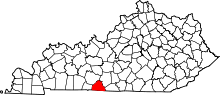
Location of Allen County in Kentucky
This is a list of the National Register of Historic Places listings in Allen County, Kentucky.
This is intended to be a complete list of the properties and districts on the National Register of Historic Places in Allen County, Kentucky, United States. The locations of National Register properties and districts for which the latitude and longitude coordinates are included below, may be seen in a map.[1]
There are 11 properties and districts listed on the National Register in the county.
- This National Park Service list is complete through NPS recent listings posted December 16, 2016.[2]
- Adair
- Allen
- Anderson
- Ballard
- Barren
- Bath
- Bell
- Boone
- Bourbon
- Boyd
- Boyle
- Bracken
- Breckinridge
- Breathitt
- Bullitt
- Butler
- Caldwell
- Calloway
- Campbell
- Carlisle
- Carroll
- Carter
- Casey
- Christian
- Clark
- Clay
- Clinton
- Crittenden
- Cumberland
- Daviess
- Edmonson
- Elliott
- Estill
- Fayette
- Fleming
- Floyd
- Franklin
- Fulton
- Gallatin
- Garrard
- Grant
- Graves
- Grayson
- Green
- Greenup
- Hancock
- Hardin
- Harlan
- Harrison
- Hart
- Henderson
- Henry
- Hickman
- Hopkins
- Jackson
- Jefferson
- Jessamine
- Johnson
- Kenton
- Knott
- Knox
- LaRue
- Laurel
- Lawrence
- Lee
- Leslie
- Letcher
- Lewis
- Lincoln
- Livingston
- Logan
- Lyon
- Madison
- Magoffin
- Marion
- Marshall
- Martin
- Mason
- McCracken
- McCreary
- McLean
- Meade
- Menifee
- Mercer
- Metcalfe
- Monroe
- Montgomery
- Morgan
- Muhlenberg
- Nelson
- Nicholas
- Ohio
- Oldham
- Owen
- Owsley
- Pendleton
- Perry
- Pike
- Powell
- Pulaski
- Robertson
- Rockcastle
- Rowan
- Russell
- Scott
- Shelby
- Simpson
- Spencer
- Taylor
- Todd
- Trigg
- Trimble
- Union
- Warren
- Washington
- Wayne
- Webster
- Whitley
- Wolfe
- Woodford
Current listings
| [3] | Name on the Register | Image | Date listed[4] | Location | City or town | Description |
|---|---|---|---|---|---|---|
| 1 | Allen County Poor Farm | Upload image | (#91001662) |
3540 Holland Rd. 36°43′37″N 86°08′31″W / 36.726944°N 86.141944°W |
Scottsville | |
| 2 | Big Spring School-Oliver Farmstead | Upload image | (#03000712) |
3293 and 3109 Big Springs Rd. 36°52′58″N 86°14′13″W / 36.882778°N 86.236944°W |
Settle | |
| 3 | Dumont Hill | 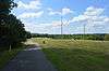 |
(#03001227) |
0.25 miles north of Kentucky Route 1386 36°45′32″N 86°11′55″W / 36.758889°N 86.198611°W |
Scottsville | |
| 4 | Dr. Pellie G. Graves House | 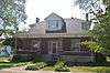 |
(#01000798) |
301 N. 4th St. 36°45′17″N 86°11′10″W / 36.754722°N 86.186111°W |
Scottsville | |
| 5 | Edward and Julia Satterfield House | Upload image | (#05001304) |
10085 Bowling Green Rd. 36°49′59″N 86°19′11″W / 36.833056°N 86.319722°W |
Scottsville | |
| 6 | Scottsville Downtown Commercial Historic District | |
(#01000797) |
Public Square and extending roughly one block north and south on Court St., and one block east and west on Main 36°45′13″N 86°11′27″W / 36.753611°N 86.190833°W |
Scottsville | |
| 7 | Scottsville Freight Depot | 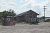 |
(#01000799) |
E. Main St. at 8th St. 36°45′10″N 86°10′54″W / 36.752778°N 86.181667°W |
Scottsville | |
| 8 | Scottsville Public Spring | 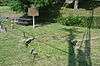 |
(#01000801) |
Junction of 1st and Locust Sts. 36°45′05″N 86°11′23″W / 36.751389°N 86.189722°W |
Scottsville | |
| 9 | The Tabernacle |  |
(#01000800) |
829 Holland Rd. 36°44′44″N 86°10′58″W / 36.745694°N 86.182778°W |
Scottsville | |
| 10 | J.L. Turner and Son Building | 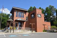 |
(#01001253) |
Old East Main St. at 7th St. 36°45′08″N 86°11′00″W / 36.752222°N 86.183333°W |
Scottsville | |
| 11 | Andrew M. Whitney House and Barn | Upload image | (#94000250) |
Kentucky Route 1855 northeast of Scottsville 36°47′37″N 86°04′01″W / 36.793611°N 86.066944°W |
Scottsville |
See also
| Wikimedia Commons has media related to National Register of Historic Places in Allen County, Kentucky. |
References
- ↑ The latitude and longitude information provided in this table was derived originally from the National Register Information System, which has been found to be fairly accurate for about 99% of listings. For about 1% of NRIS original coordinates, experience has shown that one or both coordinates are typos or otherwise extremely far off; some corrections may have been made. A more subtle problem causes many locations to be off by up to 150 yards, depending on location in the country: most NRIS coordinates were derived from tracing out latitude and longitudes off of USGS topographical quadrant maps created under the North American Datum of 1927, which differs from the current, highly accurate WGS84 GPS system used by most on-line maps. Chicago is about right, but NRIS longitudes in Washington are higher by about 4.5 seconds, and are lower by about 2.0 seconds in Maine. Latitudes differ by about 1.0 second in Florida. Some locations in this table may have been corrected to current GPS standards.
- ↑ "National Register of Historic Places: Weekly List Actions". National Park Service, United States Department of the Interior. Retrieved on December 16, 2016.
- ↑ Numbers represent an ordering by significant words. Various colorings, defined here, differentiate National Historic Landmarks and historic districts from other NRHP buildings, structures, sites or objects.
- ↑ The eight-digit number below each date is the number assigned to each location in the National Register Information System database, which can be viewed by clicking the number.
| Topics | |
|---|---|
| Lists by states |
|
| Lists by insular areas | |
| Lists by associated states | |
| Other areas | |
| |
Municipalities and communities of Allen County, Kentucky, United States | ||
|---|---|---|
| City | | |
| Unincorporated communities |
| |
This article is issued from Wikipedia - version of the 4/2/2016. The text is available under the Creative Commons Attribution/Share Alike but additional terms may apply for the media files.