| [3] |
Name on the Register |
Image |
Date listed[4] |
Location |
City or town |
Description |
|---|
| 1 |
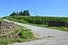
Archeological Site 15 Ne 3 |
Upload image |
000000001979-09-27-0000September 27, 1979
(#79001027) |
11 miles (18 km) north of Bardstown along the road to Lenore[5]
37°55′55″N 85°30′21″W / 37.931944°N 85.505944°W / 37.931944; -85.505944 (Archeological Site 15 Ne 3) |
Lenore |
|
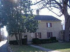
| 2 |
Baldwin's Tourist Court Residence-Office |
|
000000002011-11-10-0000November 10, 2011
(#11000797) |
321 W. Stephen Foster Ave.
37°48′36″N 85°28′20″W / 37.810000°N 85.472222°W / 37.810000; -85.472222 (Baldwin's Tourist Court Residence-Office) |
Bardstown |
|
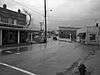
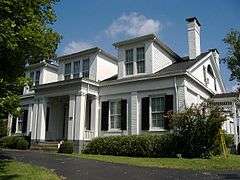
| 3 |
Bardstown Historic District |
|
000000001983-02-17-0000February 17, 1983
(#83002837) |
Roughly bounded by 1st, 3rd (U.S. Routes 31E/150), and 5th Sts., Muir Ave., and railroad track; also generally bounded by 1st St., 5th St., Muir Ave., Beall Ave., Maiden's Alley, Cherry Alley, and Mulberry Alley
37°48′40″N 85°27′57″W / 37.8111°N 85.4658°W / 37.8111; -85.4658 (Bardstown Historic District) |
Bardstown |
Second set of boundaries represents a boundary increase of 000000002010-11-10-0000November 10, 2010
|
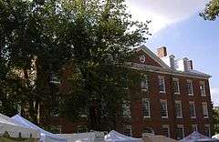
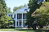
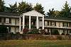
| 4 |
Beechwold |
|
000000001984-11-29-0000November 29, 1984
(#84000355) |
500 E. Stephen Foster Ave. (U.S. Routes 62/150)
37°48′34″N 85°27′19″W / 37.809444°N 85.455278°W / 37.809444; -85.455278 (Beechwold) |
Bardstown |
|
| 5 |
Bloomfield Historic District |
|
000000001991-03-18-0000March 18, 1991
(#91000234) |
Central Bloomfield, including parts of Hill, Main, Perry, and Depot Sts. and Fairfield, Springfield, and Taylorsville Roads
37°54′43″N 85°19′09″W / 37.911944°N 85.319167°W / 37.911944; -85.319167 (Bloomfield Historic District) |
Bloomfield |
|
| 6 |
Bruntwood |
|
000000001975-09-09-0000September 9, 1975
(#75000814) |
714 N. 3rd St. (U.S. Routes 31E/150)
37°49′15″N 85°27′51″W / 37.820833°N 85.464167°W / 37.820833; -85.464167 (Bruntwood) |
Bardstown |
|
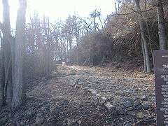
| 7 |
Cobblestone Path |
|
000000001989-11-16-0000November 16, 1989
(#89002018) |
Eastern end of Flaget Ave., northeastern to Broadway
37°48′36″N 85°27′46″W / 37.81°N 85.462778°W / 37.81; -85.462778 (Cobblestone Path) |
Bardstown |
|
| 8 |
Confederate Monument of Bardstown |
|
000000001997-07-17-0000July 17, 1997
(#97000674) |
North Bardstown Cemetery, 0.3 miles south of the junction of U.S. Routes 31E/150 and KY-245
37°49′28″N 85°27′42″W / 37.824444°N 85.461667°W / 37.824444; -85.461667 (Confederate Monument of Bardstown) |
Bardstown |
|
| 9 |
Coombs-Duncan-Brown Farmhouse |
Upload image |
000000002010-08-05-0000August 5, 2010
(#10000525) |
2985 Chaplin-Taylorsville Rd.
37°56′11″N 85°16′53″W / 37.936389°N 85.281389°W / 37.936389; -85.281389 (Coombs-Duncan-Brown Farmhouse) |
Bloomfield |
|
| 10 |
Cottage Grove Historic District |
|
000000001991-04-18-0000April 18, 1991
(#91000390) |
1015 Old Bloomfield Pike
37°49′06″N 85°27′07″W / 37.818333°N 85.451944°W / 37.818333; -85.451944 (Cottage Grove Historic District) |
Bardstown |
|
| 11 |
Culpeper |
Upload image |
000000001988-05-26-0000May 26, 1988
(#88000674) |
Northern side of Springfield Rd./U.S. Route 150
37°47′59″N 85°26′23″W / 37.799722°N 85.439722°W / 37.799722; -85.439722 (Culpeper) |
Bardstown |
|
| 12 |
Henry Duncan House |
Upload image |
000000001990-12-06-0000December 6, 1990
(#90001843) |
Taylorsville Rd. north of Maple Grove Cemetery
37°55′06″N 85°19′01″W / 37.918333°N 85.316944°W / 37.918333; -85.316944 (Henry Duncan House) |
Bloomfield |
|
| 13 |
Edgewood |
|
000000001975-07-30-0000July 30, 1975
(#75000815) |
310 S. 5th St.
37°48′21″N 85°28′17″W / 37.805833°N 85.471389°W / 37.805833; -85.471389 (Edgewood) |
Bardstown |
|
| 14 |
Frankfort and Cincinnati Model 55 Rail Car |
Upload image |
000000001998-10-08-0000October 8, 1998
(#97001344) |
136 S. Main St.
37°39′22″N 85°35′34″W / 37.656111°N 85.592778°W / 37.656111; -85.592778 (Frankfort and Cincinnati Model 55 Rail Car) |
New Haven |
|
| 15 |
Howard Brothers' Store |
Upload image |
000000001986-10-16-0000October 16, 1986
(#86002861) |
General Delivery
37°34′21″N 85°35′32″W / 37.5725°N 85.592222°W / 37.5725; -85.592222 (Howard Brothers' Store) |
Howardstown |
|
| 16 |
Ben Johnson House |
|
000000001979-07-16-0000July 16, 1979
(#79001026) |
1003 N. 3rd St. (U.S. 31E/150)
37°49′42″N 85°27′38″W / 37.828333°N 85.460556°W / 37.828333; -85.460556 (Ben Johnson House) |
Bardstown |
|
| 17 |
Silvester Johnson House and Business |
|
000000002002-04-12-0000April 12, 2002
(#02000345) |
151-153 N. Main St.
37°39′31″N 85°35′36″W / 37.658611°N 85.593333°W / 37.658611; -85.593333 (Silvester Johnson House and Business) |
New Haven |
|
| 18 |
John S. Kelley House |
|
000000001992-03-06-0000March 6, 1992
(#91001103) |
306 S. 5th St.
37°48′24″N 85°28′18″W / 37.806667°N 85.471667°W / 37.806667; -85.471667 (John S. Kelley House) |
Bardstown |
|
| 19 |
Kurtz Restaurant and Bardstown-Parkview Motel-Office |
|
000000002011-11-15-0000November 15, 2011
(#11000798) |
418 E. Stephen Foster Ave.
37°48′32″N 85°27′26″W / 37.808889°N 85.457222°W / 37.808889; -85.457222 (Kurtz Restaurant and Bardstown-Parkview Motel-Office) |
Bardstown |
|
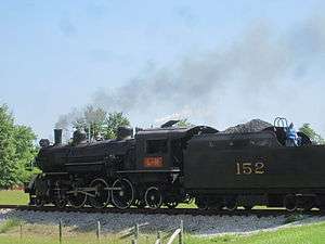
| 20 |
L & N Steam Locomotive No. 152 |
|
000000001974-12-30-0000December 30, 1974
(#74000883) |
Junction of Depot and 1st Sts.
37°39′25″N 85°35′31″W / 37.656944°N 85.591944°W / 37.656944; -85.591944 (L & N Steam Locomotive No. 152) |
New Haven |
|
| 21 |
Louisville and Nashville Combine Car Number 665 |
Upload image |
000000001997-11-19-0000November 19, 1997
(#97001343) |
136 S. Main St.
37°39′25″N 85°35′33″W / 37.656944°N 85.5925°W / 37.656944; -85.5925 (Louisville and Nashville Combine Car Number 665) |
New Haven |
|
| 22 |
Mattingly House |
Upload image |
000000001987-01-08-0000January 8, 1987
(#87000201) |
Off U.S. Route 150
37°48′27″N 85°25′27″W / 37.8075°N 85.424167°W / 37.8075; -85.424167 (Mattingly House) |
Bardstown |
|
| 23 |
Newell B. McClaskey House |
Upload image |
000000002000-03-24-0000March 24, 2000
(#00000269) |
1795 KY 1066
37°55′24″N 85°16′16″W / 37.923333°N 85.271111°W / 37.923333; -85.271111 (Newell B. McClaskey House) |
Bloomfield |
|
| 24 |
MT. BRODERICK Pullman Lounge-Obs-Sleeping Car |
Upload image |
000000001997-11-18-0000November 18, 1997
(#97001345) |
136 S. Main St.
37°39′22″N 85°35′34″W / 37.656111°N 85.592778°W / 37.656111; -85.592778 (MT. BRODERICK Pullman Lounge-Obs-Sleeping Car) |
New Haven |
|
| 25 |
My Old Kentucky Home |
|
000000001971-03-11-0000March 11, 1971
(#71000354) |
U.S. Route 150, Stephen Foster Ave.
37°48′25″N 85°27′24″W / 37.806944°N 85.456667°W / 37.806944; -85.456667 (My Old Kentucky Home) |
Bardstown |
|
| 26 |
Nelson County Jail |
|
000000001987-01-08-0000January 8, 1987
(#87000178) |
111 W. Stephen Foster St.
37°48′32″N 85°28′05″W / 37.808889°N 85.467917°W / 37.808889; -85.467917 (Nelson County Jail) |
Bardstown |
|
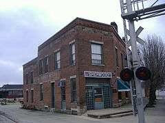
| 27 |
New Sherwood Hotel |
|
000000001992-03-26-0000March 26, 1992
(#92000291) |
138 S. Main St.
37°39′26″N 85°35′37″W / 37.657222°N 85.593611°W / 37.657222; -85.593611 (New Sherwood Hotel) |
New Haven |
|
| 28 |
Old Kentucky Home Motel |
|
000000002011-11-10-0000November 10, 2011
(#11000799) |
414 W. Stephen Foster Ave.
37°48′40″N 85°28′28″W / 37.811111°N 85.474444°W / 37.811111; -85.474444 (Old Kentucky Home Motel) |
Bardstown |
|
| 29 |
Old L & N Station |
|
000000001990-07-12-0000July 12, 1990
(#87002613) |
602 N. 3rd St. (U.S. 31E/150)
37°49′02″N 85°27′53″W / 37.817361°N 85.464722°W / 37.817361; -85.464722 (Old L & N Station) |
Bardstown |
|
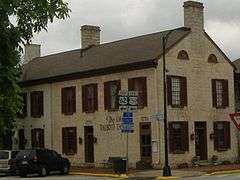
| 30 |
Old Talbott Tavern |
|
000000001973-10-30-0000October 30, 1973
(#73000822) |
Court Sq.
37°48′32″N 85°28′03″W / 37.808889°N 85.4675°W / 37.808889; -85.4675 (Old Talbott Tavern) |
Bardstown |
|
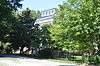
| 31 |
St. Joseph Cathedral and College Complex |
|
000000001976-06-03-0000June 3, 1976
(#76000930) |
W. Stephen Foster Ave.
37°48′39″N 85°28′15″W / 37.810833°N 85.470833°W / 37.810833; -85.470833 (St. Joseph Cathedral and College Complex) |
Bardstown |
|
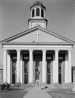
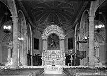
| 32 |
St. Joseph Proto Cathedral |
|
000000001974-01-09-0000January 9, 1974
(#74000897) |
W. Stephen Foster Ave.
37°48′39″N 85°28′17″W / 37.810833°N 85.471389°W / 37.810833; -85.471389 (St. Joseph Proto Cathedral) |
Bardstown |
|
| 33 |
St. Thomas Roman Catholic Church and Howard-Flaget House |
|
000000001976-07-12-0000July 12, 1976
(#76000931) |
3 miles south of Bardstown off U.S. Route 31E
37°46′00″N 85°29′01″W / 37.766667°N 85.483611°W / 37.766667; -85.483611 (St. Thomas Roman Catholic Church and Howard-Flaget House) |
Bardstown |
|
| 34 |
T. W. Samuels Distillery Historic District |
Upload image |
000000001988-11-01-0000November 1, 1988
(#88002047) |
Junction of KY 523 and Corman Railroad tracks
37°54′00″N 85°33′31″W / 37.9°N 85.558611°W / 37.9; -85.558611 (T. W. Samuels Distillery Historic District) |
Deatsville |
|
| 35 |
Sisters of Charity of Nazareth Historic District |
Upload image |
000000001984-03-15-0000March 15, 1984
(#84001425) |
North of Bardstown off U.S. Route 31E/150
37°50′59″N 85°28′22″W / 37.849722°N 85.472778°W / 37.849722; -85.472778 (Sisters of Charity of Nazareth Historic District) |
Bardstown |
|
| 36 |
Spalding Hall, St. Joseph's College |
|
000000001973-05-07-0000May 7, 1973
(#73000823) |
N. 5th St.
37°48′41″N 85°28′16″W / 37.811389°N 85.471111°W / 37.811389; -85.471111 (Spalding Hall, St. Joseph's College) |
Bardstown |
|
| 37 |
Stone House on Buffalo Creek |
Upload image |
000000001983-08-18-0000August 18, 1983
(#83002838) |
Off KY 245
37°50′29″N 85°31′11″W / 37.841389°N 85.519722°W / 37.841389; -85.519722 (Stone House on Buffalo Creek) |
Bardstown |
|
| 38 |
John Stone House |
Upload image |
000000001984-07-12-0000July 12, 1984
(#84001885) |
U.S. Route 62
37°54′11″N 85°18′45″W / 37.903056°N 85.3125°W / 37.903056; -85.3125 (John Stone House) |
Bloomfield |
|
| 39 |
Walnut Groves Farm |
Upload image |
000000001980-04-01-0000April 1, 1980
(#80001662) |
North of Bloomfield on KY 55; also 801 Taylorsville Rd.
37°55′24″N 85°19′15″W / 37.923333°N 85.320833°W / 37.923333; -85.320833 (Walnut Groves Farm) |
Bloomfield |
Taylorsville Road address represents a boundary increase
|
| 40 |
Wickland |
|
000000001973-02-16-0000February 16, 1973
(#73000824) |
0.5 miles east of Bardstown on U.S. Route 62
37°48′47″N 85°27′12″W / 37.813056°N 85.453333°W / 37.813056; -85.453333 (Wickland) |
Bardstown |
|
| 41 |
Wilson Motel |
Upload image |
000000002011-11-10-0000November 10, 2011
(#11000800) |
530 N. 3rd St.
37°49′01″N 85°27′54″W / 37.816944°N 85.465000°W / 37.816944; -85.465000 (Wilson Motel) |
Bardstown |
|


.jpg)