| [3] |
Name on the Register |
Image |
Date listed[4] |
Location |
City or town |
Description |
|---|
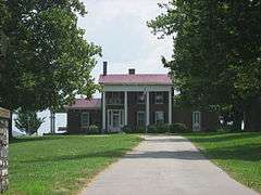
| 1 |
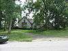
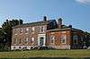
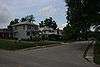
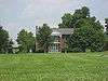
Asbury College Administration Building |
|
000000001985-07-06-0000July 6, 1985
(#85001532) |
Kentucky Route 29
37°51′49″N 84°39′43″W / 37.863611°N 84.661944°W / 37.863611; -84.661944 (Asbury College Administration Building) |
Wilmore |
Part of the Asbury College campus; renamed the "Hager Administration Building" in 1993.[5]
|
| 2 |
Craig Ashurst House |
Upload image |
000000001984-07-05-0000July 5, 1984
(#84001587) |
Off U.S. Route 27
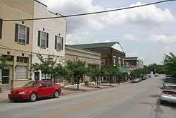
37°57′57″N 84°33′45″W / 37.965833°N 84.5625°W / 37.965833; -84.5625 (Craig Ashurst House) |
Nicholasville |
|
| 3 |
Barkley House |
Upload image |
000000001984-07-05-0000July 5, 1984
(#84001590) |
U.S. Route 68
37°54′22″N 84°37′01″W / 37.906111°N 84.616944°W / 37.906111; -84.616944 (Barkley House) |
Nicholasville |
|
| 4 |
Isaac Barkley House |
Upload image |
000000001984-07-05-0000July 5, 1984
(#84001594) |
Kentucky Route 169
37°54′52″N 84°36′32″W / 37.914444°N 84.608889°W / 37.914444; -84.608889 (Isaac Barkley House) |
Nicholasville |
|
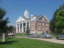
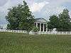
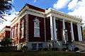
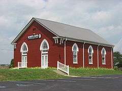
| 5 |
Bethel Academy Site (15JS80) |
Upload image |
000000001984-03-15-0000March 15, 1984
(#84001597) |
Atop bluffs above the Kentucky River at High Bridge, 4 miles from Wilmore[6]
37°49′20″N 84°42′18″W / 37.8222°N 84.705°W / 37.8222; -84.705 (Bethel Academy Site (15JS80)) |
Wilmore |
Site of the first Methodist school west of the Appalachians[6]
|
| 6 |
Bicknell House |
Upload image |
000000001984-07-05-0000July 5, 1984
(#84001600) |
Kentucky Route 29
37°51′13″N 84°40′21″W / 37.853611°N 84.6725°W / 37.853611; -84.6725 (Bicknell House) |
Wilmore |
|
| 7 |
Brick House on Shun Pike |
|
000000001984-07-05-0000July 5, 1984
(#84001601) |
Off Kentucky Route 1268
37°50′33″N 84°37′03″W / 37.8425°N 84.6175°W / 37.8425; -84.6175 (Brick House on Shun Pike) |
Nicholasville |
|
| 8 |
J.S. Bronaugh House |
|
000000001984-07-05-0000July 5, 1984
(#84001603) |
103 N. 2nd St.
37°52′53″N 84°34′28″W / 37.881389°N 84.574444°W / 37.881389; -84.574444 (J.S. Bronaugh House) |
Nicholasville |
|
| 9 |
George I. Brown House |
|
000000001977-12-02-0000December 2, 1977
(#77000632) |
206 Linden Lane
37°52′22″N 84°34′43″W / 37.872778°N 84.578611°W / 37.872778; -84.578611 (George I. Brown House) |
Nicholasville |
|
| 10 |
George and Betty Bryan House |
|
000000001984-07-05-0000July 5, 1984
(#84001606) |
U.S. Route 68
37°53′23″N 84°39′17″W / 37.889722°N 84.654722°W / 37.889722; -84.654722 (George and Betty Bryan House) |
Nicholasville |
|
| 11 |
Bryant House |
Upload image |
000000001985-07-06-0000July 6, 1985
(#85001541) |
U.S. Route 27
37°55′32″N 84°33′43″W / 37.925556°N 84.561944°W / 37.925556; -84.561944 (Bryant House) |
Nicholasville |
|
| 12 |
Burrier House |
Upload image |
000000001984-07-13-0000July 13, 1984
(#84001607) |
North of Keene
37°57′57″N 84°37′04″W / 37.965833°N 84.617778°W / 37.965833; -84.617778 (Burrier House) |
Keene |
|
| 13 |
Butler's Tavern |
|
000000001984-07-05-0000July 5, 1984
(#84001608) |
U.S. Route 27
37°50′41″N 84°35′16″W / 37.844722°N 84.587778°W / 37.844722; -84.587778 (Butler's Tavern) |
Nicholasville |
|
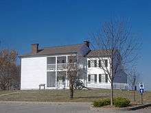
| 14 |
Camp Nelson |
|
000000002001-03-15-0000March 15, 2001
(#00000861) |
U.S. Route 27
37°47′16″N 84°35′53″W / 37.787778°N 84.598056°W / 37.787778; -84.598056 (Camp Nelson) |
Nicholasville |
|
| 15 |
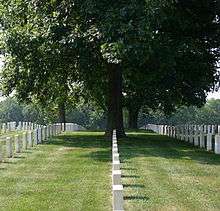
Camp Nelson National Cemetery |
|
000000001998-09-03-0000September 3, 1998
(#98001134) |
6890 Danville Rd.
37°47′07″N 84°35′59″W / 37.785278°N 84.599722°W / 37.785278; -84.599722 (Camp Nelson National Cemetery) |
Nicholasville |
|
| 16 |
Canewood Farm |
Upload image |
000000001999-04-29-0000April 29, 1999
(#99000494) |
8080 Harrodsburg Rd.
37°53′43″N 84°38′15″W / 37.895278°N 84.6375°W / 37.895278; -84.6375 (Canewood Farm) |
Nicholasville |
|
| 17 |
Chaumiere des Prairies |
|
000000001975-09-25-0000September 25, 1975
(#75000780) |
North of Nicholasville off U.S. Route 68
37°56′37″N 84°35′04″W / 37.943611°N 84.584444°W / 37.943611; -84.584444 (Chaumiere des Prairies) |
Nicholasville |
|
| 18 |
Joseph Chrisman House |
Upload image |
000000001984-07-05-0000July 5, 1984
(#84001618) |
U.S. Route 27
37°54′49″N 84°33′12″W / 37.913611°N 84.553333°W / 37.913611; -84.553333 (Joseph Chrisman House) |
Nicholasville |
|
| 19 |
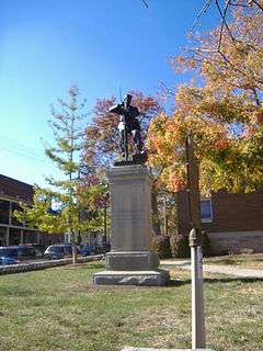
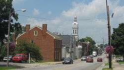
Confederate Memorial in Nicholasville |
|
000000001997-07-17-0000July 17, 1997
(#97000686) |
Courthouse lawn, junction of U.S. Route 27 and Kentucky Route 29
37°52′51″N 84°34′24″W / 37.880833°N 84.573333°W / 37.880833; -84.573333 (Confederate Memorial in Nicholasville) |
Nicholasville |
|
| 20 |
Joseph Crockett House |
Upload image |
000000002011-02-11-0000February 11, 2011
(#83004587) |
Union Mills Pike
Coordinates missing |
Nicholasville |
Early Stone Buildings of Central Kentucky Thematic Resource
|
| 21 |
Curd House |
|
000000001984-07-13-0000July 13, 1984
(#84001621) |
Kentucky Route 29
37°49′55″N 84°42′04″W / 37.831944°N 84.701111°W / 37.831944; -84.701111 (Curd House) |
Wilmore |
|
| 22 |
J.W. Duncan House |
Upload image |
000000001984-07-05-0000July 5, 1984
(#84001622) |
Kentucky Route 169
37°54′00″N 84°34′49″W / 37.9°N 84.580278°W / 37.9; -84.580278 (J.W. Duncan House) |
Nicholasville |
|
| 23 |
Nathaniel Dunn House |
Upload image |
000000001979-03-07-0000March 7, 1979
(#79001015) |
North of Nicholasville off U.S. Route 68
37°57′06″N 84°35′32″W / 37.951667°N 84.592222°W / 37.951667; -84.592222 (Nathaniel Dunn House) |
Nicholasville |
|
| 24 |
East Main Street Historic District |
|
000000001994-08-05-0000August 5, 1994
(#94000840) |
Roughly E. Main St. from S. Walnut St. to Rice St.
37°51′32″N 84°39′35″W / 37.858889°N 84.659722°W / 37.858889; -84.659722 (East Main Street Historic District) |
Wilmore |
|
| 25 |
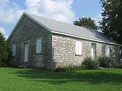
Ebenezer Presbyterian Church |
|
000000001983-06-23-0000June 23, 1983
(#83002797) |
Off Kentucky Route 1267
37°55′49″N 84°41′04″W / 37.930278°N 84.684444°W / 37.930278; -84.684444 (Ebenezer Presbyterian Church) |
Keene |
|
| 26 |
Federal House on Hickman Creek |
Upload image |
000000001985-07-06-0000July 6, 1985
(#85001542) |
West of Logana
37°52′17″N 84°29′57″W / 37.871389°N 84.499167°W / 37.871389; -84.499167 (Federal House on Hickman Creek) |
Logana |
|
| 27 |
First Vineyard |
Upload image |
000000002015-09-29-0000September 29, 2015
(#15000656) |
5800 Sugar Creek Pike
37°44′37″N 84°33′52″W / 37.7437°N 84.5645°W / 37.7437; -84.5645 (First Vineyard) |
Nicholasville |
|
| 28 |
Fort Bramlette |
Upload image |
000000001975-06-13-0000June 13, 1975
(#75000781) |
Off Fort Bramlette Road, south of Nicholasville[7]
37°45′56″N 84°35′28″W / 37.765556°N 84.591111°W / 37.765556; -84.591111 (Fort Bramlette) |
Nicholasville |
|
| 29 |
A. Grubb House |
Upload image |
000000001984-07-05-0000July 5, 1984
(#84001626) |
Kentucky Route 169
37°52′16″N 84°26′17″W / 37.871111°N 84.438056°W / 37.871111; -84.438056 (A. Grubb House) |
Spears |
|
| 30 |
Hoover House |
|
000000001984-07-05-0000July 5, 1984
(#84001629) |
U.S. Route 27
37°51′47″N 84°34′55″W / 37.863056°N 84.581944°W / 37.863056; -84.581944 (Hoover House) |
Nicholasville |
|
| 31 |
Hughes House |
Upload image |
000000001984-07-05-0000July 5, 1984
(#84001632) |
Kentucky Route 169
37°57′26″N 84°40′22″W / 37.957222°N 84.672778°W / 37.957222; -84.672778 (Hughes House) |
Keene |
|
| 32 |
John Hunter House |
Upload image |
000000001985-07-06-0000July 6, 1985
(#85001540) |
South of Logana
37°50′32″N 84°29′23″W / 37.842222°N 84.489722°W / 37.842222; -84.489722 (John Hunter House) |
Logana |
|
| 33 |
Ephriam January House |
|
000000001983-06-23-0000June 23, 1983
(#83002798) |
Address Restricted
|
Keene |
|
| 34 |
Keene Springs Hotel |
Upload image |
000000001984-07-05-0000July 5, 1984
(#84001636) |
Kentucky Route 1267
37°56′37″N 84°37′38″W / 37.943611°N 84.627222°W / 37.943611; -84.627222 (Keene Springs Hotel) |
Keene |
|
| 35 |
Kenyon Avenue Historic District |
|
000000001994-08-05-0000August 5, 1994
(#94000841) |
401, 403, 405, 406, 407, and 408 Kenyon Ave.
37°51′52″N 84°39′48″W / 37.864444°N 84.663333°W / 37.864444; -84.663333 (Kenyon Avenue Historic District) |
Wilmore |
|
| 36 |
Grant Knight House |
Upload image |
000000001984-07-05-0000July 5, 1984
(#84001639) |
Kentucky Route 169
37°55′10″N 84°36′40″W / 37.919444°N 84.611111°W / 37.919444; -84.611111 (Grant Knight House) |
Nicholasville |
|
| 37 |
John Lancaster House |
Upload image |
000000001983-06-23-0000June 23, 1983
(#83002799) |
Kentucky Route 169
37°57′12″N 84°39′09″W / 37.953333°N 84.6525°W / 37.953333; -84.6525 (John Lancaster House) |
Keene |
|
| 38 |
Lexington and Main Historic District |
|
000000001994-08-05-0000August 5, 1994
(#94000842) |
100, 101, 102, 103, and 105 N. Lexington Ave. and 101 E. Main St.
37°51′41″N 84°39′43″W / 37.861389°N 84.661944°W / 37.861389; -84.661944 (Lexington and Main Historic District) |
Wilmore |
|
| 39 |
Locust Grove Stock Farm |
Upload image |
000000001984-07-05-0000July 5, 1984
(#84001642) |
North of Keene
37°57′59″N 84°37′28″W / 37.966389°N 84.624444°W / 37.966389; -84.624444 (Locust Grove Stock Farm) |
Keene |
|
| 40 |
Log House on Shun Pike |
|
000000001984-07-05-0000July 5, 1984
(#84001645) |
Off Kentucky Route 1268
37°50′45″N 84°37′03″W / 37.845833°N 84.6175°W / 37.845833; -84.6175 (Log House on Shun Pike) |
Nicholasville |
|
| 41 |
William C. Lowry House |
Upload image |
000000001984-07-05-0000July 5, 1984
(#84001647) |
Off Kentucky Route 169
37°55′53″N 84°36′37″W / 37.931389°N 84.610278°W / 37.931389; -84.610278 (William C. Lowry House) |
Nicholasville |
|
| 42 |
Marshall-Bryan House |
|
000000001984-07-05-0000July 5, 1984
(#84001653) |
U.S. Route 27
37°56′55″N 84°32′22″W / 37.948611°N 84.539444°W / 37.948611; -84.539444 (Marshall-Bryan House) |
Nicholasville |
|
| 43 |
James G. Martin House |
Upload image |
000000001984-07-05-0000July 5, 1984
(#84001654) |
Tates Creek Rd.
37°54′38″N 84°27′51″W / 37.910556°N 84.464167°W / 37.910556; -84.464167 (James G. Martin House) |
Nicholasville |
|
| 44 |
Lewis Y. Martin House |
Upload image |
000000002008-02-07-0000February 7, 2008
(#08000009) |
6975 Tates Creek Pk.
37°54′37″N 84°27′24″W / 37.910278°N 84.456667°W / 37.910278; -84.456667 (Lewis Y. Martin House) |
Nicholasville |
|
| 45 |
McClure-Shelby House |
Upload image |
000000001978-11-20-0000November 20, 1978
(#78001372) |
5 miles (8 km) east of Nicholasville on Kentucky Route 169
37°53′15″N 84°28′49″W / 37.8875°N 84.480278°W / 37.8875; -84.480278 (McClure-Shelby House) |
Nicholasville |
|
| 46 |
McConnell-Woodson-Philips House |
|
000000001984-07-05-0000July 5, 1984
(#84001657) |
303 S. Main St.
37°52′38″N 84°34′29″W / 37.877222°N 84.574722°W / 37.877222; -84.574722 (McConnell-Woodson-Philips House) |
Nicholasville |
|
| 47 |
Morrison-Kenyon Library |
|
000000001985-07-06-0000July 6, 1985
(#85001539) |
Kentucky Route 29
37°51′48″N 84°39′46″W / 37.863333°N 84.662778°W / 37.863333; -84.662778 (Morrison-Kenyon Library) |
Wilmore |
Part of the Asbury College campus; now a student union.[5]
|
| 48 |
Mt. Pleasant Baptist Church |
Upload image |
000000001984-07-05-0000July 5, 1984
(#84001659) |
North of Keene
37°56′50″N 84°37′47″W / 37.947222°N 84.629722°W / 37.947222; -84.629722 (Mt. Pleasant Baptist Church) |
Keene |
|
| 49 |
Nave-Brown House |
|
000000001984-07-05-0000July 5, 1984
(#84001663) |
Kentucky Route 29
37°53′16″N 84°36′06″W / 37.887778°N 84.601667°W / 37.887778; -84.601667 (Nave-Brown House) |
Nicholasville |
|
| 50 |
Davis Newman House |
Upload image |
000000001984-07-05-0000July 5, 1984
(#84001669) |
West of Spears
37°52′20″N 84°26′37″W / 37.872222°N 84.443611°W / 37.872222; -84.443611 (Davis Newman House) |
Spears |
|
| 51 |
Nicholasville Historic District |
|
000000001984-07-19-0000July 19, 1984
(#84001674) |
Court Row, Maple and Main Sts.
37°52′51″N 84°34′26″W / 37.880833°N 84.573889°W / 37.880833; -84.573889 (Nicholasville Historic District) |
Nicholasville |
|
| 52 |
North Lexington Avenue Historic District |
|
000000001994-08-05-0000August 5, 1994
(#94000843) |
Roughly N. Lexington Ave. from College Ave. to Banta Ln.
37°52′00″N 84°39′29″W / 37.866667°N 84.658056°W / 37.866667; -84.658056 (North Lexington Avenue Historic District) |
Wilmore |
|
| 53 |
George O'Neal House |
Upload image |
000000001985-07-06-0000July 6, 1985
(#85001538) |
Off U.S. Route 68
37°56′43″N 84°36′34″W / 37.945278°N 84.609444°W / 37.945278; -84.609444 (George O'Neal House) |
Nicholasville |
|
| 54 |
James O'Neal House |
Upload image |
000000001985-07-06-0000July 6, 1985
(#85001537) |
Off Kentucky Route 169
37°56′02″N 84°36′28″W / 37.933889°N 84.607778°W / 37.933889; -84.607778 (James O'Neal House) |
Nicholasville |
|
| 55 |
Payne-Saunders House |
|
000000001996-07-25-0000July 25, 1996
(#96000799) |
503 N. Central Ave.
37°53′02″N 84°34′08″W / 37.883889°N 84.568889°W / 37.883889; -84.568889 (Payne-Saunders House) |
Nicholasville |
|
| 56 |
Pleasant Grove |
Upload image |
000000001984-07-05-0000July 5, 1984
(#84001678) |
North of Keene
37°57′19″N 84°37′44″W / 37.955278°N 84.628889°W / 37.955278; -84.628889 (Pleasant Grove) |
Keene |
|
| 57 |
Providence Church |
|
000000001984-07-05-0000July 5, 1984
(#84001682) |
U.S. Route 27
37°57′28″N 84°32′15″W / 37.957778°N 84.5375°W / 37.957778; -84.5375 (Providence Church) |
Nicholasville |
|
| 58 |
Roberts Chapel |
|
000000001984-07-05-0000July 5, 1984
(#84001686) |
U.S. Route 27
37°49′07″N 84°35′47″W / 37.818611°N 84.596389°W / 37.818611; -84.596389 (Roberts Chapel) |
Nicholasville |
|
| 59 |
Sandy Bluff |
|
000000001984-07-13-0000July 13, 1984
(#84001689) |
Off Kentucky Route 1268
37°51′05″N 84°36′26″W / 37.851389°N 84.607222°W / 37.851389; -84.607222 (Sandy Bluff) |
Nicholasville |
|
| 60 |
Scott House |
Upload image |
000000001983-06-23-0000June 23, 1983
(#83002800) |
U.S. Route 27
37°49′03″N 84°36′11″W / 37.8175°N 84.603056°W / 37.8175; -84.603056 (Scott House) |
Little Hickman |
|
| 61 |
John Harvey Scott House |
|
000000001984-07-13-0000July 13, 1984
(#84001692) |
Off U.S. Route 27
37°49′14″N 84°35′02″W / 37.820556°N 84.583889°W / 37.820556; -84.583889 (John Harvey Scott House) |
Nicholasville |
|
| 62 |
Shady Grove |
Upload image |
000000001985-07-06-0000July 6, 1985
(#85001536) |
Off U.S. Route 27
37°57′07″N 84°33′23″W / 37.951944°N 84.556389°W / 37.951944; -84.556389 (Shady Grove) |
Nicholasville |
|
| 63 |
Shanklin House |
Upload image |
000000001985-07-06-0000July 6, 1985
(#85001535) |
Kentucky Route 169
37°54′55″N 84°35′33″W / 37.915278°N 84.5925°W / 37.915278; -84.5925 (Shanklin House) |
Nicholasville |
|
| 64 |
Robert Steele House |
Upload image |
000000001983-06-23-0000June 23, 1983
(#83002801) |
Troy Rd.
37°54′N 84°41′W / 37.9°N 84.69°W / 37.9; -84.69 (Robert Steele House) |
Keene |
|
| 65 |
Stone House on Brooklyn Hill |
Upload image |
000000001983-06-23-0000June 23, 1983
(#83002802) |
Off U.S. Route 68
37°52′08″N 84°42′10″W / 37.868889°N 84.702778°W / 37.868889; -84.702778 (Stone House on Brooklyn Hill) |
Wilmore |
|
| 66 |
Stone House on West Hickman |
|
000000001983-06-23-0000June 23, 1983
(#83002803) |
Kentucky Route 1980
37°56′23″N 84°30′33″W / 37.939722°N 84.509167°W / 37.939722; -84.509167 (Stone House on West Hickman) |
Nicholasville |
|
| 67 |
Sunnyside Farm House |
|
000000001984-07-05-0000July 5, 1984
(#84001695) |
U.S. Route 27
37°57′34″N 84°32′10″W / 37.959444°N 84.536111°W / 37.959444; -84.536111 (Sunnyside Farm House) |
Nicholasville |
|
| 68 |
Ridge Taylor Farm |
Upload image |
000000001985-07-06-0000July 6, 1985
(#85001534) |
Off Kentucky Route 595
37°48′56″N 84°28′45″W / 37.815556°N 84.479167°W / 37.815556; -84.479167 (Ridge Taylor Farm) |
Nicholasville |
|
| 69 |
Thornwood |
Upload image |
000000001984-07-13-0000July 13, 1984
(#84001697) |
Baker Lane
37°55′16″N 84°34′39″W / 37.921111°N 84.5775°W / 37.921111; -84.5775 (Thornwood) |
Nicholasville |
|
| 70 |
Venable-Todhunter Houses |
|
000000001984-07-05-0000July 5, 1984
(#84001781) |
Tates Creek Rd.
37°56′22″N 84°28′52″W / 37.939444°N 84.481111°W / 37.939444; -84.481111 (Venable-Todhunter Houses) |
Nicholasville |
|
| 71 |
Woodland |
Upload image |
000000001984-07-05-0000July 5, 1984
(#84001783) |
U.S. Route 27
37°56′57″N 84°36′07″W / 37.949167°N 84.601944°W / 37.949167; -84.601944 (Woodland) |
Nicholasville |
|
| 72 |
Young House |
|
000000001984-07-13-0000July 13, 1984
(#84001787) |
Kentucky Route 29
37°52′58″N 84°38′31″W / 37.882778°N 84.641944°W / 37.882778; -84.641944 (Young House) |
Nicholasville |
|
| 73 |
A.M. Young House |
Upload image |
000000001985-07-06-0000July 6, 1985
(#85001533) |
West of Ash Grove Pike
37°56′21″N 84°29′38″W / 37.939167°N 84.493889°W / 37.939167; -84.493889 (A.M. Young House) |
Nicholasville |
|


.jpg)
.jpg)
.jpg)
.jpg)
.jpg)