National Register of Historic Places listings in Ohio County, Kentucky
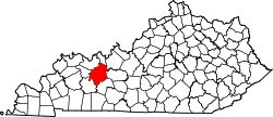
Location of Ohio County in Kentucky
This is a list of the National Register of Historic Places listings in Ohio County, Kentucky.
This is intended to be a complete list of the properties and districts on the National Register of Historic Places in Ohio County, Kentucky, United States. The locations of National Register properties and districts for which the latitude and longitude coordinates are included below, may be seen in a map.[1]
There are 19 properties and districts listed on the National Register in the county, of which 1 is a National Historic Landmark and 6 are part of another National Historic Landmark spread across multiple counties.
- This National Park Service list is complete through NPS recent listings posted December 16, 2016.[2]
- Adair
- Allen
- Anderson
- Ballard
- Barren
- Bath
- Bell
- Boone
- Bourbon
- Boyd
- Boyle
- Bracken
- Breckinridge
- Breathitt
- Bullitt
- Butler
- Caldwell
- Calloway
- Campbell
- Carlisle
- Carroll
- Carter
- Casey
- Christian
- Clark
- Clay
- Clinton
- Crittenden
- Cumberland
- Daviess
- Edmonson
- Elliott
- Estill
- Fayette
- Fleming
- Floyd
- Franklin
- Fulton
- Gallatin
- Garrard
- Grant
- Graves
- Grayson
- Green
- Greenup
- Hancock
- Hardin
- Harlan
- Harrison
- Hart
- Henderson
- Henry
- Hickman
- Hopkins
- Jackson
- Jefferson
- Jessamine
- Johnson
- Kenton
- Knott
- Knox
- LaRue
- Laurel
- Lawrence
- Lee
- Leslie
- Letcher
- Lewis
- Lincoln
- Livingston
- Logan
- Lyon
- Madison
- Magoffin
- Marion
- Marshall
- Martin
- Mason
- McCracken
- McCreary
- McLean
- Meade
- Menifee
- Mercer
- Metcalfe
- Monroe
- Montgomery
- Morgan
- Muhlenberg
- Nelson
- Nicholas
- Ohio
- Oldham
- Owen
- Owsley
- Pendleton
- Perry
- Pike
- Powell
- Pulaski
- Robertson
- Rockcastle
- Rowan
- Russell
- Scott
- Shelby
- Simpson
- Spencer
- Taylor
- Todd
- Trigg
- Trimble
- Union
- Warren
- Washington
- Wayne
- Webster
- Whitley
- Wolfe
- Woodford
Current listings
| [3] | Name on the Register | Image | Date listed[4] | Location | City or town | Description |
|---|---|---|---|---|---|---|
| 1 | Archeological Site KHC-6 (15OH97) | Upload image | (#86000655) |
Foot of Kirtley-River Rd. at the Green River above Livermore[5] 37°26′12″N 87°06′08″W / 37.436667°N 87.102222°W |
Kirtley | Part of the Green River Shell Middens Archeological District National Historic Landmark[6]:30 |
| 2 | J.T. Barnard Shell Midden (KHC-1) | Upload image | (#86000669) |
Across the Green River from South Carrollton[5] 37°20′12″N 87°07′48″W / 37.336667°N 87.130000°W |
Central City | Part of the Green River Shell Middens Archeological District National Historic Landmark[6]:29 |
| 3 | Bowles Site (15OH13) | Upload image | (#86000656) |
Northern side of the Green River opposite Rochester[7] 37°12′51″N 86°53′52″W / 37.214167°N 86.897778°W |
Rochester | Part of the Green River Shell Middens Archeological District National Historic Landmark[6]:27 |
| 4 | Ceralvo Masonic Hall and School | Upload image | (#15000655) |
942 Ceralvo Rd. 37°21′59″N 87°01′52″W / 37.3663°N 87.031°W |
Centertown | |
| 5 | Chiggerville Site (15OH1) | Upload image | (#86000665) |
Right bank of the Green River, 3 miles (4.8 km) above the Paradise Fossil Plant[8] 37°14′25″N 86°56′29″W / 37.240278°N 86.941389°W |
Knightsburg | Part of the Green River Shell Middens Archeological District National Historic Landmark[6]:25 |
| 6 | Downtown Hartford Historic District | 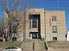 |
(#88002760) |
Roughly the 100 and 200 blocks of Main St. and Courthouse Sq. 37°27′04″N 86°54′32″W / 37.451111°N 86.908889°W |
Hartford | |
| 7 | Dundee Masonic Lodge No. 733 |  |
(#08000213) |
11640 Kentucky Route 69 N. 37°33′25″N 86°46′22″W / 37.556944°N 86.772778°W |
Dundee | |
| 8 | Hartford Seminary |  |
(#73000826) |
224 E. Center St. 37°27′07″N 86°54′23″W / 37.451944°N 86.906389°W |
Hartford | |
| 9 | Samuel E. Hill House | 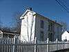 |
(#80001663) |
519 E. Union St. 37°27′28″N 86°54′16″W / 37.457639°N 86.904444°W |
Hartford | |
| 10 | Indian Knoll | Upload image | (#66000362) |
Right bank of the Green River opposite the Paradise Fossil Plant at Paradise[9] 37°15′50″N 86°58′24″W / 37.263889°N 86.973333°W |
Paradise | |
| 11 | Jackson Bluff Site (15OH12) | Upload image | (#86000666) |
Address Restricted |
Rockport | |
| 12 | Jimtown Site (15OH19) | Upload image | (#86000667) |
Jimtown Hill, 2 miles (3.2 km) above Livermore[5] 37°28′00″N 87°06′32″W / 37.466667°N 87.108889°W |
Kirtley | Part of the Green River Shell Middens Archeological District National Historic Landmark[6]:28 |
| 13 | Louisville, Henderson, and St. Louis Railroad Depot |  |
(#91000923) |
Southeastern side of Walnut St., 200 feet north of its junction with Kentucky Route 54 37°38′11″N 86°43′01″W / 37.636389°N 86.716944°W |
Fordsville | |
| 14 | Bill Monroe Farm | Upload image | (#03000648) |
Approximately 2 miles west of the junction of U.S. Route 62 and Kentucky Route 1544 37°25′58″N 86°45′53″W / 37.432778°N 86.764722°W |
Rosine | |
| 15 | Old Town Historic District | 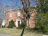 |
(#88002535) |
Roughly bounded by E. Union, Clay, E. Washington and Liberty Sts. 37°27′08″N 86°54′24″W / 37.452222°N 86.906667°W |
Hartford | |
| 16 | Pendleton House | 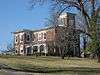 |
(#73000827) |
403 E. Union St. 37°27′17″N 86°54′21″W / 37.454722°N 86.905833°W |
Hartford | |
| 17 | Rosine General Store and Barn | Upload image | (#03000708) |
8205 Blue Moon off U.S. Route 62 37°27′02″N 86°44′28″W / 37.450556°N 86.741111°W |
Rosine | |
| 18 | Smallhous Shell Mound (15OH10) | Upload image | (#86000668) |
Right bank of the Green River at Smallhous[10] 37°22′49″N 87°05′33″W / 37.380278°N 87.092500°W |
Smallhous | Part of the Green River Shell Middens Archeological District National Historic Landmark[6]:26 |
| 19 | Charles Wallace House | Upload image | (#84001890) |
Address Restricted |
Hartford |
See also
| Wikimedia Commons has media related to National Register of Historic Places in Ohio County, Kentucky. |
- List of National Historic Landmarks in Kentucky
- National Register of Historic Places listings in Kentucky
References
- ↑ The latitude and longitude information provided in this table was derived originally from the National Register Information System, which has been found to be fairly accurate for about 99% of listings. For about 1% of NRIS original coordinates, experience has shown that one or both coordinates are typos or otherwise extremely far off; some corrections may have been made. A more subtle problem causes many locations to be off by up to 150 yards, depending on location in the country: most NRIS coordinates were derived from tracing out latitude and longitudes off of USGS topographical quadrant maps created under the North American Datum of 1927, which differs from the current, highly accurate WGS84 GPS system used by most on-line maps. Chicago is about right, but NRIS longitudes in Washington are higher by about 4.5 seconds, and are lower by about 2.0 seconds in Maine. Latitudes differ by about 1.0 second in Florida. Some locations in this table may have been corrected to current GPS standards.
- ↑ "National Register of Historic Places: Weekly List Actions". National Park Service, United States Department of the Interior. Retrieved on December 16, 2016.
- ↑ Numbers represent an ordering by significant words. Various colorings, defined here, differentiate National Historic Landmarks and historic districts from other NRHP buildings, structures, sites or objects.
- ↑ The eight-digit number below each date is the number assigned to each location in the National Register Information System database, which can be viewed by clicking the number.
- 1 2 3 Claassen, Cheryl. Feasting with Shellfish in the Southern Ohio Valley: Archaic Sacred Sites and Rituals. Knoxville: U of Tennessee P, 2010, 41.
- 1 2 3 4 5 6 National Historic Landmark Nomination: Green River Shell Middens. National Park Service: 1994-05-05.
- ↑ Emerson, Thomas E. Archaic Societies: Diversity and Complexity Across the Midcontinent. Albany: SUNY Press, 2009, 655.
- ↑ Moore, Christopher R. Production, Exchange, and Social Interaction in the Green River Region of Western Kentucky: A Multiscalar Approach to the Analysis of Two Shell Midden Sites. Diss. University of Kentucky, 2011, 163.
- ↑ Funkhouser, W.D., and W.S. Webb. "Archaeological Survey of Kentucky: Butler County". University of Kentucky Reports in Anthropology 7.5 (1950): 324.
- ↑ Moore, Clarence B. "Some Aboriginal Sites on Green River, Kentucky". Journal of the Philadelphia Academy of Natural Sciences 16 (1916): 431-487: 443.
| Topics | |
|---|---|
| Lists by states |
|
| Lists by insular areas | |
| Lists by associated states | |
| Other areas | |
| |
Municipalities and communities of Ohio County, Kentucky, United States | ||
|---|---|---|
| Cities | | |
| CDP | ||
| Other unincorporated communities | ||
This article is issued from Wikipedia - version of the 9/9/2016. The text is available under the Creative Commons Attribution/Share Alike but additional terms may apply for the media files.