East Nusa Tenggara
| East Nusa Tenggara Nusa Tenggara Timur | |||
|---|---|---|---|
| Province | |||
|
| |||
| |||
 Location of East Nusa Tenggara in Indonesia | |||
| Coordinates: 10°11′S 123°35′E / 10.183°S 123.583°ECoordinates: 10°11′S 123°35′E / 10.183°S 123.583°E | |||
| Country |
| ||
| Capital |
| ||
| Government | |||
| • Governor | Frans Lebu Raya (PDI-P) | ||
| • Vice Governor | Benny Alexander Litelnoni | ||
| Area | |||
| • Total | 48,718.10 km2 (18,810.16 sq mi) | ||
| Population (2014 Estimate)[1] | |||
| • Total | 5,070,746 | ||
| • Density | 100/km2 (270/sq mi) | ||
| Demographics | |||
| • Ethnic groups |
Atoni or Dawan (22%) Manggarai (15%) Sumba (12%) Belu (9%) Lamaholot (8%) Rote (5%) Lio (4%)[2] | ||
| • Religion |
Roman Catholicism (54.14%) Protestantism (34.74%) Islam (9.05%) Other (3%)[3] | ||
| • Languages | Indonesian, Kupang Malay, Lamaholot, Uab Meto, Bunak, Tetum | ||
| Time zone | WITA (UTC+08) | ||
| Vehicle registration | DH, EB, ED | ||
| HDI |
| ||
| HDI rank | 31st (2014) | ||
| Website | www.nttprov.go.id | ||

East Nusa Tenggara (Indonesian: Nusa Tenggara Timur – NTT) is a province of Indonesia. It is located in the eastern part of the Lesser Sunda Islands and includes West Timor. It has a total area of 48,718.1 km2, and the population at the 2010 Census was 4,683,827; the latest official estimate in January 2014 was 5,070,746. The provincial capital is Kupang on West Timor.
The province consists of more than 500 islands, the three largest being Flores, Sumba, and the western half of Timor (West Timor). The eastern part of Timor is the independent country of East Timor. East Nusa Tenggara is the only province in Indonesia where Roman Catholicism is the predominant religion. Nusa Tenggara Timur, in Indonesian, means "eastern southeastern islands"; compare to Nusa Tenggara Barat, which means "western southeastern islands".
History
After the declaration of Indonesian independence in 1945, the eastern part of Indonesia declared the State of East Indonesia.[4] The state was further included in the United States of Indonesia as part of the agreement with the Dutch contained in the transfer its sovereignty to Indonesia in 1949.
In 1950, United States of Indonesia dissolved itself into a unitary state and began to divide its component area into provinces. In 1958, by Indonesian law (Undang-Undang) No. 64/1958, three provinces were established in the Lesser Sunda Islands, namely Bali, West Nusa Tenggara and East Nusa Tenggara.[5] The area of East Nusa Tenggara province included the western part of Timor island, Flores, Sumba and other several small islands in the region. The province was sub-divided into twelve regencies and the City of Kupang, which had regency-level status.[6]
Following the fall of the Suharto regime in 1998 and the passage of a new regional autonomy law, there was a dramatic proliferation (known as pemekaran) of regional governments across Indonesia (at both provincial and regency level). Several new regencies were created in East Nusa Tenggara by the division of existing regencies:
- In 1999, the new Lembata Regency was formed after the division of the East Flores Regency.[7]
- In 2002, Rote and Ndao Islands were split off from Kupang Regency, to form a new Rote Ndao Regency.[8]
- In 2003, Manggarai Regency was split into two and a new West Manggarai Regency was established.[9]
- In 2007, the administration of East Nusa Tenggara province was expanded by the establishment of four new regencies - Central Sumba and Southwest Sumba (both cut out of West Sumba Regency), Nagekeo (cut out of Ngada Regency) and East Manggarai (cut out of Manggarai Regency).
- In October 2008 a further regency - Sabu Raijua (comprising the Savu Islands group) - was formed from part of the remaining Kupang Regency.
- In December 2012 yet another regency - Malaka - was created out of the southern half of Belu Regency.
Therefore, as of early 2013, there were twenty-one regencies plus the one autonomous city (Kupang) in the province.
Geography
Located in the east of Lesser Sunda Islands, East Nusa Tenggara faces the Indian Ocean in the south and Flores Sea in the north. The province is bordered by other provinces, West Nusa Tenggara in the west. In the east, the province is bordered by East Timor and southern part of Maluku.

The province consists of about 566 islands, the largest and most dominant are Flores, Sumba, and the western part of Timor. The other is smaller islands include Adonara, Alor, Komodo, Lembata (formerly called Lomblen), Menipo, Raijua, Rincah, Rote Island (the southernmost island in Indonesia), Savu, Semau, and Solor. The highest point in the province is Mount Mutis in the South Central Timor Regency, 2,427 meters above sea level.[10]

Administrative divisions
The province is divided into twenty-one regencies and one city. These are listed below with their areas and their populations at the 2010 Census and at the latest (2014) estimates:[11]
| Name | Statute (including year when established) | Area (km2) | Population 2010 Census | Population 2014 estimate[11] | Capital |
|---|---|---|---|---|---|
| Alor Regency (Alor Archipelago) | UU 69/1958 | 2,864.60 | 190,026 | 205,724 | Kalabahi |
| East Flores Regency (Flores Timur) (includes Adonara and Solor) | UU 69/1958 | 1,813.20 | 232,605 | 251,820 | Larantuka |
| East Manggarai Regency (Manggarai Timur) | UU 36/2007 | 2,642.93 | 252,744 | 273,623 | Borong |
| Ende Regency | UU 69/1958 | 2,046.50 | 260,605 | 282,133 | Ende |
| Lembata Regency (Lomblen) | UU 52/1999 | 1,266.00 | 117,829 | 127,563 | Lewoleba |
| Manggarai Regency | UU 69/1958 | 2,096.44 | 292,451 | 316,610 | Ruteng |
| Nagekeo Regency | UU 2/2007 | 1,416.96 | 130,120 | 140,869 | Mbay |
| Ngada Regency | UU 69/1958 | 1,645.88 | 142,393 | 154,156 | Bajawa |
| Sikka Regency | UU 69/1958 | 1,731.90 | 300,328 | 325,137 | Maumere |
| West Manggarai Regency (Manggarai Barat) (includes Komodo and Rinca) | UU 8/2003 | 2,397.03 | 221,703 | 240,017 | Labuan Bajo |
| Northern (Flores) group | 19,921.44 | 2,140,804 | 2,317,652 | ||
| Central Sumba Regency (Sumba Tengah) | UU 3/2007 | 1,868.74 | 62,485 | 67,647 | Waibakul |
| East Sumba Regency (Sumba Timur) | UU 69/1958 | 7,000.50 | 227,732 | 246,544 | Waingapu |
| Southwest Sumba Regency (Sumba Barat Daya) | UU 16/2007 | 1,480.46 | 284,903 | 308,438 | Tambolaka |
| West Sumba Regency (Sumba Barat) | UU 69/1958 | 2,183.18 | 111,993 | 120,162 | Waikabubak |
| Southwestern (Sumba) group | 12,532.88 | 687,113 | 742,791 | ||
| Kupang City | 26.18 | 336,239 | 364,014 | Kupang | |
| Belu Regency | UU 69/1958 | 2,445.60 | 352,297 | 381,399 | Atambua |
| Kupang Regency | UU 69/1958 | 5,434.76 | 304,548 | 329,706 | Oelmasi |
| Malaka Regency | 2012 | included in Belu Regency | included in Belu Regency | included in Belu Regency | Betun |
| North Central Timor Regency (Timor Tengah Utara) | UU 69/1958 | 2,669.70 | 229,803 | 248,786 | Kefamenanu |
| Rote Ndao Regency | UU 9/2002 | 1,280.00 | 119,908 | 129,813 | Baa |
| Sabu Raijua Regency | Oct. 2008 | 460.54 | 72,960 | 78,987 | West Savu |
| South Central Timor Regency (Timor Tengah Selatan) | UU 69/1958 | 3,947.00 | 441,155 | 477,598 | Soe |
| Southeastern (Timor) group | 16,264.78 | 1,856,910 | 2,010,303 |
Provincial Government
Below is a list of Governors who have held office in the East Nusa Tenggara.
- J. Lala Mentik (1960–1965)
- El Tari (1966–1978)
- Ben Mboi (1978–1988)
- Hendrik Fernandez (1988–1993)
- Herman Musakabe (1993–1998)
- Piet Alexander Tallo (1998–2008)
- Frans Lebu Raya (2008–present)
Demographics
| Historical population | ||
|---|---|---|
| Year | Pop. | ±% |
| 1971 | 2,295,287 | — |
| 1980 | 2,737,166 | +19.3% |
| 1990 | 3,268,644 | +19.4% |
| 1995 | 3,577,472 | +9.4% |
| 2000 | 3,952,279 | +10.5% |
| 2010 | 4,683,827 | +18.5% |
| Source: Badan Pusat Statistik 2010 | ||
The population of the province was 4,679,316 in 2010,[12] but the most recent estimate was 5,070,746 (as at January 2014). The religious mix is atypical of Indonesia with around 90% Christian (majority Catholic, but with a large Protestant population), 8% Muslim, 0.6% Hindu or Buddhist, and 0.4% holding traditional beliefs. East Nusa Tenggara has become a refuge for Indonesian Christians fleeing from conflict in Maluku and Irian Jaya.
The secondary school enrolment rate of 39% is dramatically below the Indonesian average (80% in 2003/04, according to UNESCO). Lack of clean drinking water, sanitation, and health facilities mean that child malnutrition (32%) and child mortality (71 per 1000) are higher than in most of the rest of Indonesia.[13] Maternal and infant mortality are high partly because of poor access to health facilities in isolated rural areas.[14] Malaria is a significant problem in parts of the province with the result that the rate of infant mortality caused by malaria, in recent years, as been the highest across Indonesia.[15]
Economy
By several economic indicators, the provincial economy is weaker than the Indonesian average with high inflation (15%), unemployment (30%) and interest rates (22-24%), making it one of the poorest provinces in Indonesia.
Agriculture
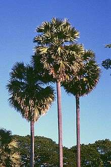
A main part of the economic activity in the province is subsistence agriculture. Important local crops include corn and some smallholder plantation crops such as coffee. In some places such as Sumba, the lontar palm (Borassus flabellifer) dominates local agricultural activities and is a very important part of the local economy.[16] In these areas, the lontar palm provides timber and thatching as well as food in the form of fruits, and palm sugar which is obtained by tapping the fruit stems. The sugary sap can be used to make alcoholic drinks. In other parts of the province such as West Manggarai, the sugar palm (Arenga pinnata) has a useful role in the local economy.[17] The degree of mechanisation in agriculture is low. Large animals (buffaloes, horses) are widely used throughout the province.[18]
Natural resources
A significant part of the economic activity in the province involves the development of natural resources, including forestry and numerous local mining ventures. Some of the activity is controversial, however, because regulatory controls over the use of natural resources are not always effective. There have been disputes in some areas over the use of land. Manganese mining, for example, in the central part of the island of Timor has been controversial.[19] Nearby, in the Mount Mutis area to the east of Kupang, amongst some local groups there is concern at the way local resources are being developed by mining companies.[20]
There is also significant activity in the informal mining sector. Across the province, villagers sometimes exploit localised opportunities to undertake unregulated mining or mineral-based projects. In West Timor, for example, in the South Central Timor Regency, villagers living near the south coast in the Kolbano area south of the town of Soe sometimes collect coloured stones which, in turn, are sold to companies which export the stones to countries such as Australia, China, Malaysia, Singapore, and elsewhere.[21]
The cultivation of seaweed is an important activity in some parts of the province. In the Alor Islands, for example, village-based informal cultivation of seaweed helps boost local incomes. Much of the seaweed is exported in unprocessed form, including to countries such as Japan in north Asia. One view is that more needs to be done to encourage further domestic processing of the seaweed to add value before export; however the local skills and facilities for further processing are not well-developed and it is not clear that a program to encourage further processing would be successful.[22]
Growth and development
Levels of poverty in the province compared with other parts are Indonesia are relatively high. In 2010, 23% of the population were classified as poor (using very modest poverty lines of around $25 and $17 per person per month for urban and rural areas respectively) compared to the all-Indonesia average of 13.3%.[23] The numbers of street children in the province, for example, are relatively high.[24] Localised food shortages are common.[25] Around 50% of the children in the province suffer from stunting.[26] The challenges of promoting development and lifting living standards in a rather isolated area of Indonesia such as NTT are considerable. The main problems of development include the following:
- Differences in living standards between urban and rural areas are large; rural poverty is widespread.[27]
- Agriculture is underdeveloped with little use of modern technology or capital, and poor access to markets
- Deforestation, which exacerbates problems of water management and access to water in the province[28]
- Infrastructure in the province is underdeveloped. Roads are often poor, especially in rural areas. There is relatively little electricity throughout NTT; electricity use in 2010 was at the very low level of around 90 kWh per capita compared to the all-Indonesia rate of around 630 kWh (and often over 10,000 kWh per capita in the main OECD countries).
- Access to water in a major problem. The province is dry for much of the year and in rural areas many of the villages must rely on unreliable and untreated local springs and other sources for water supplies.[29] The percentage of households relying on spring water was around 40% in 2010, the highest for any province in Indonesia and well above the all-Indonesia average of 14%.[30] Water shortages are thus a major local social and political issue in the province.[31]
- Local education and medical facilities are poor and neglected. Although the numbers of schools and local medical clinics are adequate compared to other parts of Indonesia, the quality of services provided in these institutions is often poor. And in some areas, key facilities are absent; in mid-2014 it was reported that two districts (West Manggarai and East Manggarai) did not have general hospitals.[32]
- Resources available to the provincial and regency governments are very limited so it is difficult for local governments to improve the supply of public services.
Tourism

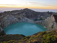
In 2016 East Nusatenggara got 6 medals from 10 categories of Anugerah Pesona Indonesia 2016. Gold medal of Most Popular Surfing Spot of Nemberala Beach, Rote Ndao Regency; Gold medal of Most Popular Cleanliness of Nihiwatu Beach, West Sumba Regency; Gold medal of Most Popular of Historical Site of Ende Bung Karno (Proclamator and the first Indonesia President) Site; Gold medal of Most Popular Diving Site of Alor Island, Alor Regency; Silver medal of Most Popular Attraction of Pasola, Southwest Sumba Regency; Bronze medal of Most Popular Highland of different color of three lakes/calderas of Mount Kelimutu, Ende.[33]
The provincial government aims to promote tourism.[34] There are various interesting locations in the province.[35] The basic infrastructure to support the tourist sector (such as transport facilities, accommodation, and adequate and reliable information) needs to be strengthened but several main features of the tourist sector in the province include:[36]
- Komodo Island with the well-known Komodo dragon
- Kelimutu volcano on Flores which contains 3 striking crater lakes of varying colors
- Mount Mutis to the east of Kupang, the highest point in the province and an area known for hiking & bird-watching[37]
- Semana Santa in Larantuka
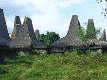
- Traditional housing and pasola in Sumba Island
- Alor Dive in Alor Island
- Nemberalla Beach in Rote Ndao
- Pink Beach in Padar island
- Taman 17 in Riung Island
Various local community groups in the province work to promote the local tourist industry although, as yet, many of these activities are still somewhat underdeveloped and need strengthening.[38]
Well-known figures
Well-known figures from the province include the following:
- Izaak Huru Doko, an independence fighter who organised resistance against the Dutch NICA (Netherlands-Indies Civil Administration) in the 1940s[39]
- Wilhelmus Zakaria Johannes, regarded as the first Indonesian radiologist in Indonesia. The W.Z Johannes hospital in Kupang is named after him.[40]
- Frans Seda, a politician and finance minister (1966–1968) of Indonesia
- Adrianus Mooy, an economist who was governor of Bank Indonesia (1988–1993) and Executive Director of ESCAP
- Ben Mboi, former East Nusa Tenggara governor
- Herman Johannes, scientist, government minister, and Rector of Gadjah Mada University (1961–1966)
Sources of information
Useful sources of detailed information about the province (mainly in Indonesian) are the following:
- The NTT website of the Indonesian Central Statistics Bureau (Badan Pusat Statistik or BPS) which provides data on a range of matters in the province. Especially helpful is the annual publication NTT dalam Angka [NTT in Figures] which provides very extensive statistics about a wide range of issues.
- The quarterly reports of economic conditions in NTT issued by the provincial branch of Bank Indonesia.
- The local Kupang newspaper Pos Kupang provides local news coverage of many provincial events.
- Website on music from the islands of Roti and Lombok.
References
- ↑ Central Bureau of Statistics: Census 2010, retrieved 17 January 2011 (Indonesian)
- ↑ Indonesia's Population: Ethnicity and Religion in a Changing Political Landscape, Institute of Southeast Asian Studies, 2003
- ↑ 2008 estimate
- ↑ Statute of Staatsblad No. 143, 1946.
- ↑ Government of Indonesia (11 August 1958), Establishment of the First-level Administrative Regions of Bali, West Nusa Tenggara and East Nusa Tenggara (in Indonesian ed.), Indonesia Ministry of Law and Justice, UU No. 64/1958, retrieved 2007-08-24
- ↑ Government of Indonesia (9 August 1958), Establishment of the Second-level Administrative Regions under the First-level Administrative Region of Bali, West Nusa Tenggara and East Nusa Tenggara (in Indonesian ed.), Indonesia Ministry of Law and Justice, UU No. 69/1958, retrieved 2007-08-24
- ↑ Government of Indonesia (4 October 1999), Establishment of Lembata Regency in the East Nusa Tenggara province (in Indonesian ed.), Indonesia Ministry of Law and Justice, UU No. 52/1999, retrieved 2007-08-24
- ↑ Government of Indonesia (10 April 2002), Establishment of Rote-Ndao Regency in the East Nusa Tenggara province (PDF) (in Indonesian ed.), Indonesia Ministry of Law and Justice, UU No. 9/2002, retrieved 2007-08-24
- ↑ Government of Indonesia (25 February 2003), Establishment of West Manggarai Regency in the East Nusa Tenggara province (PDF) (in Indonesian ed.), Indonesia Ministry of Law and Justice, UU No. 8/2003, retrieved 2007-08-24
- ↑ "The Meto People on Mutis Mountain". Travel Destination Indonesia. Retrieved 3 July 2010.
- 1 2 Estimasi Penduduk Mennurat Jenis Kelamin dan Provinsi di Indonesia Tahun 2014.
- ↑ Statistics Indonesia [Central Statistics Bureau] (2012), Statistik Indonesia, Statistical yearbook of Indonesia 2011, Jakarta.
- ↑ Yemris Fointuna, "Babies in East Nusa Tenggara face threat of malnutrition", The Jakarta Post, 30 March 2011.
- ↑ "The Ills of Medical Care in Flores", The Jakarta Globe, 13 April 2009.
- ↑ Yemris Fointuna, "Malaria threatens children in E. Nusa Tenggara", The Jakarta Post, 27 August 2012.
- ↑ James J. Fox (1977), Harvest of the palm: ecological change in Eastern Indonesia, Harvard University Press, Boston.
- ↑ Markus Makur, "Abraham Manggas: Rescuing sugar palms", The Jakarta Post, 14 August 2012.
- ↑ Markus Makur, "Horses down, buffaloes up in NTT", The Jakarta Post, 5 May 2012.
- ↑ Yemris Fointuna, "Bishop urges a stop of manganese mining in W. Timor", The Jakarta Post, 16 April 2011.
- ↑ Emmy Fitri, "'Indonesian Avatar' Fights Miners in Nusa Tenggara Timur", The Jakarta Globe, 15 February 2012.
- ↑ Yemris Fointuna, "East Nusa Tenggara: Farmers shift tactics to collecting stones", The Jakarta Post, 4 August 2012.
- ↑ "Farming the Alor Islands: One man's weed", The Economist, 18 December 2013.
- ↑ Badan Pusat Statistik (BPS), Statistik Indonesia; Statistical Pocketbook of Indonesia: 2010, Jakarta, 2011.
- ↑ Panca Nugraha, "NTB home to 12.000 street children", The Jakarta Post, 29 March 2012.
- ↑ "100,000 People Facing 'Food Crisis' in Eastern Indonesia: Official", The Jakarta Globe, 13 September 2011.
- ↑ Lydia Tomkiw, "Villagers Being Enlisted in Fight Against Infant Stunting", The Jakarta Globe, 13 September 2011.
- ↑ Taco Bottema, Keppi Sukesi and Simon Seran, "NTT at a Crossroads", 14 October 2009, a report commissioned by the United Nations in Indonesia.
- ↑ Markus Makur, Marselinus Agot: Three million trees for Manggarai Raya', The Jakarta Post, 30 September 2011.
- ↑ Yemris Fointuna, "Water deficit leads to consumption of dirty water", The Jakarta Post, 17 September 2012.
- ↑ BPS statistics, op cit.
- ↑ "10 years on E. Nusa Tenggara village still suffers from water crisis", The Jakarta Post, 4 May 2012.
- ↑ Markus Makur, 'Regencies in NTT desperately need general hospitals', The Jakarta Post, 31 July 2014.
- ↑ Kormelis Kaha (September 17, 2016). "NTT juara umum Anugerah Pesona Indonesia 2016".
- ↑ A useful guide to NTT which is in Indonesian but which, nevertheless, has much accessible information and maps about NTT is by Gagas Ulung (2011), Exotic NTT: 200 tempat paling menantang dan eksotis di provinsi Nusa Tenggara Timur: wisata alam, bahari, budaya, dan tradisi [Exotic NTT: 200 of the most challenging and exotic places in Nusa Tenggara Timur: tourism for nature, the sea, culture, and tradition], PT Gramedia Pustaka Utama, Jakarta.
- ↑ A short guide to some of the key sites on Flores is Anett Keller, "Beauty and the East", The Jakarta Post Weekender, 30 November 2011
- ↑ "NTT natural wonders to boost economic development". July 6, 2012.
- ↑ Neville Kemp, "Bird-watching on Timor a rewarding experience", The Jakarta Post, 3 May 2005.
- ↑ Markus Makur, "Yoseph Ugis: Never give up", The Jakarta Post, 28 December 2012.
- ↑ Tim Gudang Ilmu (2011), Pahlawan Indonesia & profilnya: edisi terlengkap [Profiles of heroes of Indonesia; a complete edition], Gudang Ilmu, Jakarta.
- ↑ Tim Gudang Ilmu, op. cit.
External links
| Wikivoyage has a travel guide for East Nusa Tenggara. |
 Media related to East Nusa Tenggara at Wikimedia Commons
- Official website
- Official site of the NTT Tourist Office
Regencies and cities of East Nusa Tenggara | ||
|---|---|---|
Capital: Kupang | ||
| Regencies |  | |
| Cities | ||
Capital: Jakarta | ||
| Sumatra |  | |
| Java | ||
| Kalimantan | ||
| Lesser Sunda | ||
| Sulawesi | ||
| Maluku | ||
| Papua | ||
| Special Regions | ||
| Former Province | ||
Lists by
| ||