Raichur district
| Raichur district ರಾಯಚೂರು ಜಿಲ್ಲೆ | |
|---|---|
| District | |
|
| |
 | |
| Coordinates: 16°13′N 77°21′E / 16.21°N 77.35°ECoordinates: 16°13′N 77°21′E / 16.21°N 77.35°E | |
| Country |
|
| State | Karnataka |
| Division | Gulbarga Division |
| Headquarters | Raichur |
| Talukas | Raichur, Sindhanur, Lingsugur, Manvi, Devadurga |
| Government | |
| • District collector | S Sasikanth Senthil , IAS |
| Area† | |
| • Total | 8,386 km2 (3,238 sq mi) |
| Elevation | 400.0 m (1,312.3 ft) |
| Population (2001) | |
| • Total | 1,669,762 |
| • Density | 200/km2 (520/sq mi) |
| Languages | |
| • Official | Kannada |
| Time zone | IST (UTC+5:30) |
| PIN | 584101,584102,584103 |
| Telephone code | 08532 |
| ISO 3166 code | IN-KA-RA |
| Vehicle registration | KA-36 |
| Sex ratio | 0.983 ♂/♀ |
| Literacy | 48.8% |
| Lok Sabha constituency | Raichur Lok Sabha constituency |
| Precipitation | 680.6 millimetres (26.80 in) |
| Website |
raichur |
| †Raichur district at a glance | |

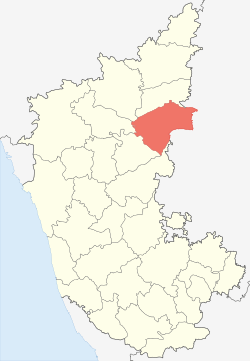
Raichur District is an administrative district in the Indian state of Karnataka. It is located in the northeast part of the state and is bounded by Yadgir district in the north, Bijapur and Bagalkot district in the northwest, Koppal district in the west, Bellary district in the south, Mahabubnagar district of Telangana and Kurnool district of Andhra Pradesh in the east.
Geography
The district is bounded by the Krishna River on the north and the Tungabhadra River on the south. The wedge of land between the rivers is known as the Raichur Doab, after the city of Raichur. Bijapur and Gulbarga districts lie to the north across the Krishna River. Bagalkot and Koppal districts lie to the west. Across the Tungabhadra lies Bellary District of Karnataka to the southwest and Mahabubnagar of Telangana to the southeast. Kurnool District of Andhra Pradesh state lies to the east, and includes the lower portion of the Raichur-584 102...
History
The recorded history of the district is traced to as far back as the third century B.C. The fact that three minor rock edicts of Ashoka are found in this district one at Maski in the Lingasugur taluk and the other two near Koppal, prove that this area was included in the dominions of the great Mauryan king Ashoka (273 - 236 B.C.). At that time, this region was under the governance of the Viceroy or Mahamatra of Ashoka. Early in the Christian era, the district appears to have been a part of the kingdom of the Satavahanas. The Vakatakas, who reigned during the 3rd and 4th centuries A.D., seem to have held sway over Raichur for sometime, after which it appears to have been included in the Kadamba dominions. The next dynasty of importance, which ruled over this region, was that of the Chalukyas of Badami. According to an inscription from Aihole, Pulakeshin II having defeated the Pallavas, occupied this area and made it a province in his empire under the governance of his son Adityavarma. Later the whole of the present Raichur district was included in the dominions of the Rashtrakutas, who rose to power in the eighth century, as could be gathered from the inscriptions of that period found in this district. According to an inscription from Manvi taluk, one Jagattunga, a subordinate ruler under the Rashtrakuta king Krishna-II, was ruling the province of Adedore Eradusavirapranta, i.e., the area constituting the present Raichur district. Nripatunga, a Rashtrakuta king, has described Koppal in his Kannada work, Kavirajamarga, as the great Kopananagara.
Numerous inscriptions of the Western Chalukyas, found in the various parts of the district, testify to the fact that this region was under their sway for a considerable length of time between the 10th and 12th centuries A.D. It is learnt from an inscription found at Naoli in Lingsugur taluk that during the reign of Chalukya Vikramaditya-V, the Adedore-pranta, i.e., the Raichur region, was being ruled by his younger brother Jagadekamalla-I. Another inscription from Maski describes the place as a capital and makes a reference to the reign of Jayasimha. There were, however, frequent wars between the Chola kings of the south and the Chalukyan kings of Kalyani (aka Western Chalukyas) for supremacy over the Raichur region and the territory had passed into the hands of the Cholas for a brief period. The Haihayas and Sindas also seem to have ruled some parts of this region for sometime. Later, after the fall of the Chalukyas, Raichur passed into the hands of the Kalachuris of Kalyani and later Sevna Yadava kings. Then came the Kakatiyas in the 13th century. From an inscription on the fort-wall of Raichur, referred to earlier, it is learn that the original fort was built by one Gore Gangayya Reddy, a general of the Kakatiya queen Rudramma Devi of Warangal, in 1294 A.D., at the instance of the latter.[1] Raichur was sacked by Malik Kafur, was commander of Sultanate of Delhi in 1312.
Raichur district was passed to Vijayanagara Empire in 1323 after demise of Kakatiyas due to invasions of Sultanate of Delhi. It was captured by Bahmani Sultanate in 1363. It was passed to Bijapur Sultanate in 1489 after fragmentation of Bahmanids. Vijayanagara recaptured it after Battle of Raichur in 1520 but Bijapur recaptured it in 1565 after Vijayanagara's defeat at hands of Deccan Sultanates during Battle of Talikota. Aurangzeb, emperor of Mughal Empire captured the district in 1686. Finally 1724 Raichur became part of Nizam of Hyderabad between 1724 and 1948 except British Empire rule between 1853 and 1860 as part of Madras Presidency. During Nizam rule it was part of Gulbarga Division.
After the Operation Polo, Nizam was forcibly integrated to Indian Union on 17 September 1948. Between 1948 and 1956, it was part of Hyderabad State. During division of the state on linguistic basis, it became part of Mysore State and later was renamed State of Karnataka.
Demographics
According to the 2011 census Raichur district has a population of 1,924,773,[2] roughly equal to the nation of Lesotho[3] or the US state of West Virginia.[4] This gives it a ranking of 246th in India (out of a total of 640).[2] The district has a population density of 228 inhabitants per square kilometre (590/sq mi) .[2] Its population growth rate over the decade 2001-2011 was 15.27%.[2] Raichur has a sex ratio of 992 females for every 1000 males,[2] and a literacy rate of 60.46%.[2]
Raichur District has five taluks: Raichur, Devadurga, Sindhanur, Manvi and Lingsugur. The capital of the district is the city of Raichur, which is 409 km from the state capital, Bangalore.
Tourism
Among the historical attractions in the district is the Raichur Fort, built in 1294. Also notable is the nearby town of Anegundi, which has a number of monuments from the Vijayanagara empire, including the Ranganatha temple, Pampa Lake and Kamal Mahal,
MahaLaxmi Temple is located in a nearby village, Kallur, at a distance of 20 km from Raichur. Sri Sugureshwara Temple (Lord Veerabadhra) is in Deosugur village at the bank of river Krishna, about 18 km from Raichur. Both temples are easily accessible at all times via bus routes.
- Maski is a town and an archaeological site. The site has an edict of Emperor Ahoka and it was the first edict of Emperor Ashoka that contained the name Ashoka in it instead of the earlier edicts that referred him as Devanampiye piyadasi.
- Mudgal The main attractions Mudgal are the remnants of the Mudgal fort and an ancient Roman Catholic church built by the Jesuits before 1557.
- Hatti Gold Mines This mine is probably one of the most ancient metal mines in the world, dating to the Pre-Ashokan period. It is the only functioning Gold mine in India.
- Naradagadde is a holy place where Lord Narada is believed to have performed penace. Naradagadde and Koormagadde are islands famous the temples and are located on Krishna river.
- Jaladurga is a fortified village. The Adil Shahi Kings of Bijapur built the fort.
- Piklihal is a pre-historic site belonging to neolithic period is located 5 km south to Mudgal.
- Kallur archaeological site is a Copper Hoard culture site in Manvi taluk of Raichur. Kallur archaeological site is 30 km from Raichur.
Economy

The Raichur Thermal Power Station at Shaktinagar in this district provides a large portion of the electricity consumption in Karnataka.
Raichur District is one of few places in India with gold resources. Hatti Gold Mines are situated in Raichur District, around 90 km away from Raichur city. All the five talukas mentioned above are very well irrigated, with water from the Tungabhadra Dam on the Tungabhadra River, and Narayanpura Dam on the Krishna River. Raichur is known for its paddy fields and its rice is of extremely superior quality. Raichur has numerous rice mills which export high quality rice to different countries. It also has a good trading market in cotton industry.
In 2006 the Ministry of Panchayati Raj named Raichur one of the country's 250 most backward districts (out of a total of 640).[5] It is one of the five districts in Karnataka currently receiving funds from the Backward Regions Grant Fund Programme (BRGF) and that is going to local politicians home.[5]
References
- ↑ http://www.raichur.nic.in/History.htm
- 1 2 3 4 5 6 "District Census 2011". Census2011.co.in. 2011. Retrieved 30 September 2011.
- ↑ US Directorate of Intelligence. "Country Comparison:Population". Retrieved 1 October 2011.
Lesotho 1,924,886
- ↑ "2010 Resident Population Data". U. S. Census Bureau. Retrieved 30 September 2011.
West Virginia 1,852,994
- 1 2 Ministry of Panchayati Raj (8 September 2009). "A Note on the Backward Regions Grant Fund Programme" (PDF). National Institute of Rural Development. Retrieved 27 September 2011.
External links
| Wikimedia Commons has media related to Raichur district. |
 |
Bijapur district | Yadgir district | Gulbarga district | |
| Bagalkot district | |
Mahbubnagar district, Telangana | ||
| ||||
| | ||||
| Koppal district | Bellary district | Kurnool district, Andhra Pradesh |