Saint-Nicolas-d'Aliermont
| Saint-Nicolas-d’Aliermont | ||
|---|---|---|
| ||
 Saint-Nicolas-d’Aliermont | ||
|
Location within Normandy region  Saint-Nicolas-d’Aliermont | ||
| Coordinates: 49°52′48″N 1°13′16″E / 49.88°N 1.2211°ECoordinates: 49°52′48″N 1°13′16″E / 49.88°N 1.2211°E | ||
| Country | France | |
| Region | Normandy | |
| Department | Seine-Maritime | |
| Arrondissement | Dieppe | |
| Canton | Envermeu | |
| Intercommunality | Monts et Vallées | |
| Government | ||
| • Mayor (2008–2014) | Blandine Lefebvre | |
| Area1 | 15.53 km2 (6.00 sq mi) | |
| Population (2006)2 | 3,843 | |
| • Density | 250/km2 (640/sq mi) | |
| Time zone | CET (UTC+1) | |
| • Summer (DST) | CEST (UTC+2) | |
| INSEE/Postal code | 76624 / 76510 | |
| Elevation |
40–164 m (131–538 ft) (avg. 132 m or 433 ft) | |
|
1 French Land Register data, which excludes lakes, ponds, glaciers > 1 km² (0.386 sq mi or 247 acres) and river estuaries. 2 Population without double counting: residents of multiple communes (e.g., students and military personnel) only counted once. | ||
Saint-Nicolas-d’Aliermont is a commune in the Seine-Maritime department in the Haute-Normandie region in north-western France.
Geography
A small town of farming and light industry situated in the Pays de Bray, at the junction of the D149, the D256 and the D56 roads, some 9 miles (14 km) southeast of Dieppe.
Heraldry
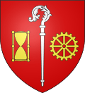 |
The arms of Saint-Nicolas-d'Aliermont are blazoned : Gules, an episcopal crozier argent between an hourglass and a toothed wheel of 8 spokes Or. |
Population
| 1962 | 1968 | 1975 | 1982 | 1990 | 1999 | 2006 |
|---|---|---|---|---|---|---|
| 2635 | 3216 | 3614 | 3964 | 4055 | 3862 | 3843 |
| Starting in 1962: Population without duplicates | ||||||
Places of interest
See also
References
External links
| Wikimedia Commons has media related to Saint-Nicolas-d'Aliermont. |
- Official website of the commune (French)
- Saint-Nicolas-d’Aliermont on the Quid website (French)
This article is issued from Wikipedia - version of the 7/13/2016. The text is available under the Creative Commons Attribution/Share Alike but additional terms may apply for the media files.