Shinano Province
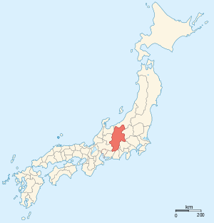
Shinano Province (信濃国 Shinano no kuni) or Shinshū (信州) is an old province of Japan that is now present-day Nagano Prefecture.[1]
Shinano bordered on Echigo, Etchū, Hida, Kai, Kōzuke, Mikawa, Mino, Musashi, Suruga, and Tōtōmi Provinces. The ancient capital was located near modern-day Matsumoto, which became an important city of the province.
The World War II–era Japanese aircraft carrier Shinano was named after this old province.
Historical record
In 713, the road that traverses Mino and Shinano provinces was widened to accommodate increasing numbers of travelers through the Kiso District of modern Nagano Prefecture.[2]
In the Sengoku Period, Shinano Province was often split among fiefs and castle towns developed, including Komoro, Ina, and Ueda. Shinano was one of the major centers of Takeda Shingen's power during his wars with Uesugi Kenshin and others.
Suwa taisha was designated as the chief Shinto shrine (ichinomiya) for the province.[3]
In 1871, during the Meiji period, with the abolition of the han system and the establishment of prefectures (Haihan Chiken) after the Meiji Restoration, Shinano Province was administratively separated in 1871 into Nagano and Chikuma prefectures. These two tentative governmental and territorial units were reconfigured together again in 1876. This became the modern prefecture of Nagano, which remains substantially unchanged from that time.
Historical districts
Shinano Province contained the following districts:
- Nagano Prefecture
- Azumi District (安曇郡)
- Kitaazumi District (北安曇郡)
- Minamiazumi District (南安曇郡) - dissolved
- Chiisagata District (小県郡)
- Chikuma District (筑摩郡)
- Higashichikuma District (東筑摩郡)
- Nishichikuma District (西筑摩郡) - renamed as Kiso District (木曽郡) on May 1, 1968
- Hanishina District (埴科郡)
- Minochi District (水内郡)
- Kamiminochi District (上水内郡)
- Shimominochi District (下水内郡)
- Saku District (佐久郡)
- Kitasaku District (北佐久郡)
- Minamisaku District (南佐久郡)
- Sarashina District (更級郡) - dissolved
- Takai District (高井郡)
- Kamitakai District (上高井郡)
- Shimotakai District (上高井郡)
- Azumi District (安曇郡)
- Former Suwa Province districts
- Ina District (伊那郡)
- Kamiina District (上伊那郡)
- Shimoina District (下伊那郡)
- Suwa District (諏訪郡)
- Ina District (伊那郡)
See also
- Tomono clan
- Iiyama Domain
- Susaka Domain
- Matsushiro Domain
- Ueda Domain
- Komoro Domain
- Matsumoto Domain
- Okutono Domain
- Suwa Domain
- Takatō Domain
- Ōhama Domain
Notes
- ↑ Nussbaum, Louis-Frédéric. (2005). "Ōmi" in Japan Encyclopedia, p. 863, p. 863, at Google Books.
- ↑ Titsingh, Isaac. (1834). Annalles des empereurs du japon, p. 64., p. 64, at Google Books
- ↑ "Nationwide List of Ichinomiya," p. 2.; retrieved 2011-08-010
References
- Nussbaum, Louis-Frédéric and Käthe Roth. (2005). Japan encyclopedia. Cambridge: Harvard University Press. ISBN 978-0-674-01753-5; OCLC 58053128.
- Hiroaki Sato (2008). Japanese women poets: an anthology. M.E. Sharpe, Inc.
- Titsingh, Isaac. (1834). Annales des empereurs du Japon (Nihon Odai Ichiran). Paris: Royal Asiatic Society, Oriental Translation Fund of Great Britain and Ireland. OCLC 5850691.
External links
| Wikimedia Commons has media related to Shinano Province. |
- Murdoch's map of provinces, 1903
- Hokusai, A View of Mount Fuji across Lake Suwa, c. 1831