Tōtōmi Province
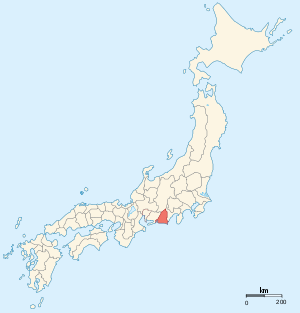
Tōtōmi Province (遠江国 Tōtōmi-no kuni) was a province of Japan in the area of Japan that is today western Shizuoka Prefecture.[1] Tōtōmi bordered on Mikawa, Suruga and Shinano Provinces. Its abbreviated form name was Enshū (遠州). The origin of its name is the old name of Lake Hamana.
History
Tōtōmi was one of the original provinces of Japan established in the Nara period under the Taihō Code. The original capital of the province was located in what is now Iwata, and was named “Mitsuke” – a name which survived into modern times as Mitsuke-juku, a post station on the Tōkaidō. Under the Engishiki classification system, Tōtōmi was ranked as a "superior country" (上国) in terms of importance, and one of the 16 “middle countries” (中国) in terms of distance from the capital.
During the early Muromachi period, Tōtōmi was ruled nominally by the Imagawa clan before coming under control of the Shiba clan. However, by the Sengoku period, the Imagawa recovered Tōtōmi and effectively annexed it to Suruga Province. After the defeat of the Imagawa at the Battle of Okehazama, Tōtōmi was divided between the powerful warlords Takeda Shingen of Kai and Tokugawa Ieyasu of Mikawa. To consolidate his new holdings, Tokugawa Ieyasu constructed Hamamatsu Castle, which effectively became the capital of the province, although parts of Tōtōmi continued to be contested between the Tokugawa and Takeda until Shingen’s death.
After the Battle of Odawara and the rise to power of Toyotomi Hideyoshi, Tokugawa Ieyasu was forced to trade his domains in the Tōkai region for the Kantō region instead. Hamamatsu was relinquished to the Horii clan and subsidiary Kakegawa Castle to Yamauchi Kazutoyo. After the establishment of the Tokugawa Shogunate, the Tokugawa recovered their lost territories, and reassigned Tōtōmi to various fudai daimyo.
During the Edo period, the Tōkaidō road from Edo to Kyoto passed through Tōtōmi, with post stations at several locations. For defensive purposes, the Tokugawa shogunate forbid the construction of bridges on the major rivers (such as at the Tenryu River), which further led to town development on the major river crossings.
At the end of the Tokugawa Shogunate, Tōtōmi Province was divided among several feudal domains, which were assigned to close fudai retainers. Following the defeat of the Tokugawa shogunate during the Boshin War of the Meiji restoration, the last Tokugawa Shōgun, Tokugawa Yoshinobu returned to Suruga in 1868 to rule the short-lived Shizuoka Domain, and the existing daimyo in Tōtōmi were reassigned to other territories, mostly in Kazusa Province
With the abolition of the han system in 1871 by the new Meiji government., Tōtōmi became the short-lived Hamamatsu Prefecture until 1876. On August 21, 1876, Tōtōmi was joined with former Suruga and Izu provinces to form the new Shizuoka Prefecture. Many former samurai of Tōtōmi, now unemployed due to the change in regime, were settled in the Makinohara region, where they developed the green tea industry. With the coming of the Tōkaidō Main Line railway, Hamamatsu developed rapidly into a major commercial and industrial center, especially in connection with the cotton and silk spinning industries.
Historical districts
- Shizuoka Prefecture
- Aratama District (麁玉郡) - merged into Inasa District on April 1, 1896
- Fuchi District (敷知郡) - merged into Hamana District (along with Nakagami District) on April 1, 1896
- Haibara District (榛原郡)
- Hamana District (浜名郡) - absorbed Fuchi and Nakagami Districts on April 1, 1896; now dissolved
- Inasa District (引佐郡) - absorbed Aratama District on April 1, 1896; now dissolved
- Iwata District (磐田郡) - absorbed Toyoda and Yamana Districts on April 1, 1896; now dissolved
- Kitō District (城東郡) - merged with Saya District to become Ogasa District (小笠郡) on April 1, 1896
- Nagakami District (長上郡) - merged into Hamana District (along with Fuchi District) on April 1, 1896
- Saya District (佐野郡) - merged with Kitō District to become Ogasa District on April 1, 1896
- Shūchi District (周智郡)
- Toyoda District (豊田郡) - merged into Iwata District (along with Yamana District) on April 1, 1896
- Yamana District (山名郡) - merged into Iwata District (along with Toyoda District) on April 1, 1896
Bakumatsu period domains
| Name | type | daimyo | kokudaka | notes |
|---|---|---|---|---|
| Hamamatsu Domain | fudai | Inoue | 60,000 koku | |
| Kakegawa Domain | fudai | Ōta | 50,000 koku | |
| Sagara Domain | fudai | Tanuma | 10,000 koku | |
| Yokosuka Domain | fudai | Nishio | 10,000 koku | |
Highways
Notes
- ↑ Nussbaum, Louis-Frédéric. (2005). "Tōtōmi" in Japan Encyclopedia, p. 990, p. 990, at Google Books.
References
- Nussbaum, Louis-Frédéric and Käthe Roth. (2005). Japan encyclopedia. Cambridge: Harvard University Press. ISBN 978-0-674-01753-5; OCLC 58053128
- Papinot, Edmond. (1910). Historical and Geographic Dictionary of Japan. Tokyo: Librarie Sansaisha. OCLC 77691250
- (Japanese) Tōtōmi on "Edo 300 HTML"
External links
![]() Media related to Totomi Province at Wikimedia Commons
Media related to Totomi Province at Wikimedia Commons