St. Clair Shores, Michigan
| St. Clair Shores, Michigan | |
|---|---|
| City | |
| Nickname(s): The Shores | |
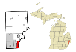 Location of St. Clair Shores, Michigan | |
| Coordinates: 42°29′16″N 82°53′48″W / 42.48778°N 82.89667°W | |
| Country | United States |
| State | Michigan |
| County | Macomb |
| Government | |
| • Mayor | Kip C. Walby |
| • Councilmembers | John D. Caron, Ronald J. Frederick, Peter A. Rubino, Candice B. Rusie, Peter Accica, and Christopher M. Vitale |
| • City Manager | Mike Smith |
| Area[1] | |
| • Total | 14.28 sq mi (36.99 km2) |
| • Land | 11.62 sq mi (30.10 km2) |
| • Water | 2.66 sq mi (6.89 km2) 18.63% |
| Elevation | 577 ft (176 m) |
| Population (2010)[2] | |
| • Total | 59,715 |
| • Estimate (2012[3]) | 59,749 |
| • Density | 5,139.0/sq mi (1,984.2/km2) |
| Time zone | Eastern (EST) (UTC-5) |
| • Summer (DST) | EDT (UTC-4) |
| ZIP codes | 48080, 48081, 48082 |
| Area code(s) | 586 |
| FIPS code | 26-70760 |
| GNIS feature ID | 0636601[4] |
| Website | http://www.scsmi.net/ |
St. Clair Shores is a suburban city bordering Lake St. Clair in Macomb County of the U.S. state of Michigan. It forms a part of the Metro Detroit area, and is located approximately 13 miles (21 km) northeast of downtown Detroit. The population was 59,715 at the 2010 census. The current mayor is Kip C. Walby, and the current council members are John D. Caron, Ronald J. Frederick, Peter A. Rubino, Candice B. Rusie, Anthony G. Tiseo, and Christopher M. Vitale.
Geography

According to the United States Census Bureau, the city has a total area of 14.28 square miles (36.99 km2), of which 11.62 square miles (30.10 km2) is land and 2.66 square miles (6.89 km2) is water.[1] A notable feature of St. Clair Shores is its 14 miles (23 km) of canals. Most of these canals are found in the Nautical Mile, which is along Jefferson between 9 and 10 Mile.
Neighboring communities
 |
Clinton Township | Clinton Township | Harrison Township | |
| Roseville | |
Lake Saint Clair | ||
| ||||
| | ||||
| Harper Woods | Harper Woods - Grosse Pointe Woods | Grosse Pointe Woods |
History and culture
The area was inhabited by French settlers as early as 1710, at which time it was called L'anse Creuse. (L'anse Creuse was also the name of a stop on the now-defunct interurban railroad off of Jefferson Ave near Nine Mile Road, and the name lives on today in the L'Anse Creuse Public Schools in central Macomb County, MI and L'Anse Creuse High School in Harrison Twp.)
From 1843 until 1911, St. Clair Shores was a part of Erin Township, parts of which make up today's Eastpointe, Roseville, and St. Clair Shores. In 1911, the eastern portion of the township now occupied by St. Clair Shores was partitioned from Erin Township to become Lake Township. Lake Township existed until 2009, when residents of the village of Grosse Pointe Shores (that portion of Grosse Pointe Shores in Macomb County located within Lake Township) voted to incorporate as a city.
A community called Eagle Pointe was established along the part of the lakeshore in 1916.[5]
The city once was home to an amusement park named Jefferson Beach. Built in 1927, it featured the longest roller coaster in the United States. In 1955, a fire destroyed several buildings in the park. While Jefferson Beach attempted to rebuild, its owners slowly converted the park to a marina. In 1959, the remaining amusement park buildings were demolished to make room for the marina.
With help from its location along the shores of Lake Saint Clair, St. Clair Shores grew from a resort community to a suburban city rapidly after World War II. Prior to the city's incorporation in 1951, St. Clair Shores was recognized as the largest village in the United States.
The tallest building in St. Clair Shores is the 28-story Shore Club Highrise, known locally as "9 Mile Tower", located on Nine Mile Road and Jefferson Avenue near Lake Saint Clair.
Each year, St. Clair Shores hosts a popular Memorial Day Parade, which includes many of the local sports teams and marching bands. The city is also known for its "Nautical Mile" - a strip of Jefferson Avenue between Nine Mile and 10 Mile roads featuring many retail establishments, restaurants, boat dealers, and marinas.
St. Clair Shores is home to one of the longest running local pageants as a member of the Miss America Organization. The Miss St. Clair Shores program offers scholarships to young women in the community ages 17–24. The pageant itself is held in July at the local South Lake High School, located near 9 mile and Mack Ave. Miss St. Clair Shores volunteers and serves her city during her preparation to compete at the Miss Michigan Pageant.
The city is also known for its connection to Detroit's musical history. Notable locations include the now closed Car City Records, which was located on Harper between 8 and 9 Mile roads (whose employees have included many from the Detroit music scene) and the Crows Nest East, a popular music venue in the 1960s which was located on Harper and 13 Mile Road. Many groups who played here went on to regional or national fame later.
St. Clair Shores is also well known for its hockey association, with more state championships than any other rink in the entire state. High school hockey during the 1970s dominated the competition; one team from Lakeview even went undefeated in 1973, and won the championship. There are still signs and vintage Hockeytown bumper stickers hanging inside the arena. In 2016, the town also became home to a Federal Hockey League team, the St. Clair Shores Fighting Saints.
Naming
Being situated on the western shores of Lake Saint Clair, the city's name is taken from the lake. An expedition led by the French explorer René Robert Cavelier, Sieur de La Salle named it Lac Sainte-Claire, because they entered the lake on August 12, 1679, the feast day of Saint Clare of Assisi.[6] The lake is named on English maps as early as 1710 as Saint Clare. But as early as the Mitchell Map in 1755, the spelling is presented with the current spelling as St. Clair.[7] The name is sometimes attributed as honoring the American Revolutionary War General and Governor of the Northwest Territory Arthur St. Clair, but the name was in use with the current spelling long before St. Clair was a notable figure. However it is possible that earlier name of the lake was conflated with that of the general in naming some of the political entities near the lake and the river, such as St. Clair County St. Clair Township, and the cities of St. Clair and St. Clair Shores.
The origin of the name has also been confused with that Patrick Sinclair, a British officer who purchased land on the St. Clair River at the outlet of the Pine River. There, in 1764, he built Fort Sinclair, which was in use for nearly twenty years before being abandoned.[8]
Demographics
| Historical population | |||
|---|---|---|---|
| Census | Pop. | %± | |
| 1930 | 6,745 | — | |
| 1940 | 10,405 | 54.3% | |
| 1950 | 19,823 | 90.5% | |
| 1960 | 76,657 | 286.7% | |
| 1970 | 88,093 | 14.9% | |
| 1980 | 76,210 | −13.5% | |
| 1990 | 68,107 | −10.6% | |
| 2000 | 63,096 | −7.4% | |
| 2010 | 59,715 | −5.4% | |
| Est. 2015 | 59,903 | [9] | 0.3% |
| U.S. Decennial Census 2011 estimate | |||
2010 census
As of the census[2] of 2010, there were 59,715 people, 26,585 households, and 15,932 families residing in the city. The population density was 5,139.0 inhabitants per square mile (1,984.2/km2). There were 28,467 housing units at an average density of 2,449.8 per square mile (945.9/km2). The racial makeup of the city was 92.7% White, 3.9% African American, 0.3% Native American, 1.0% Asian, 0.2% from other races, and 1.7% from two or more races. Hispanic or Latino of any race were 1.7% of the population.
There were 26,585 households of which 24.6% had children under the age of 18 living with them, 43.6% were married couples living together, 11.9% had a female householder with no husband present, 4.4% had a male householder with no wife present, and 40.1% were non-families. 35.1% of all households were made up of individuals and 15.5% had someone living alone who was 65 years of age or older. The average household size was 2.24 and the average family size was 2.90.
The median age in the city was 44.2 years. 19% of residents were under the age of 18; 7% were between the ages of 18 and 24; 24.9% were from 25 to 44; 29.7% were from 45 to 64; and 19.2% were 65 years of age or older. The gender makeup of the city was 47.8% male and 52.2% female.
2000 census
As of the census of 2000, there were 63,096 people, 27,434 households, and 17,283 families residing in the city. The population density was 5,472.3 per square mile (2,112.9/km²). There were 28,208 housing units at an average density of 2,446.5 per square mile (944.6/km²). The racial makeup of the city was 96.89% White, 0.69% African American, 0.28% Native American, 0.84% Asian, 0.02% Pacific Islander, 0.18% from other races, and 1.10% from two or more races. Hispanic or Latino of any race were 1.18% of the population.
There were 27,434 households out of which 24.1% had children under the age of 18 living with them, 49.5% were married couples living together, 10.0% had a female householder with no husband present, and 37.0% were non-families. 32.7% of all households were made up of individuals and 16.3% had someone living alone who was 65 years of age or older. The average household size was 2.28 and the average family size was 2.92.
In the city the population was spread out with 20.2% under the age of 18, 6.2% from 18 to 24, 28.8% from 25 to 44, 23.1% from 45 to 64, and 21.8% who were 65 years of age or older. The median age was 42 years. For every 100 females there were 90.9 males. For every 100 females age 18 and over, there were 86.8 males.
The median income for a household in the city was $49,047, and the median income for a family was $59,245. Males had a median income of $46,614 versus $31,192 for females. The per capita income for the city was $25,009. About 2.6% of families and 3.7% of the population were below the poverty line, including 4.4% of those under age 18 and 4.9% of those age 65 or over.
Education
Located in St. Clair Shores are the South Lake Schools, Lakeview Public Schools, and Lake Shore Public Schools public school districts; each district includes a high school. Private schools include St. Germaine, St. Isaac Jogues and St. Joan of Arc within the city.
Notable people
- George Allen - football coach in the National Football League and United States Football League; member of the Pro Football Hall of Fame
- Dave Coulier - actor and comedian
- David Debol - member of the NHL Hartford Whalers, (1979–81)
- Anne Fletcher - dancer, choreographer and film director
- Faye Grant - actress
- Donald Patrick Harvey - actor (Die Hard 2, Walker, Texas Ranger)
- Ken Kal - Kenneth "Ken" Kalczynski - sports announcer for WXYT (AM) in Detroit and the longtime radio play-by-play commentator for the Detroit Red Wings of the National Hockey League
- Fred "Sonic" Smith - guitarist, member of the bands MC5 and Sonic's Rendezvous Band
- Patti Smith - singer-songwriter and member of the Rock and Roll Hall of Fame
- Werner Spitz - forensic pathologist
- Mark Wells - member of the 1980 United States Olympic hockey team; Miracle on Ice
- Rachelle Wilkos - Rachelle Consiglio-Wilkos - producer and wife of television personality Steve Wilkos
- John Ziegler, Jr. (1952) – President of the National Hockey League (1977-1992) and member of the Hockey Hall of Fame (1987)[10]
See also
References
Notes
- 1 2 "US Gazetteer files 2010". United States Census Bureau. Retrieved 2012-11-25.
- 1 2 "American FactFinder". United States Census Bureau. Retrieved 2012-11-25.
- ↑ "Population Estimates". United States Census Bureau. Retrieved 2013-06-03.
- ↑ "US Board on Geographic Names". United States Geological Survey. 2007-10-25. Retrieved 2008-01-31.
- ↑ Romig 1986, p. 167.
- ↑ Jenks, p. 22
- ↑ Jenks, pp. 23-24
- ↑ Fuller, pp. 21-22
- ↑ "Annual Estimates of the Resident Population for Incorporated Places: April 1, 2010 to July 1, 2015". Retrieved July 2, 2016.
- ↑ Business of Playing Hockey
Sources
- Romig, Walter (October 1, 1986) [1973]. Michigan Place Names: The History of the Founding and the Naming of More Than Five Thousand Past and Present Michigan Communities. Great Lakes Books Series (Paperback). Detroit, Michigan: Wayne State University Press. ISBN 0-8143-1838-X. ISBN 978-0814318386.
External links
- Official Website of the City of St. Clair Shores
- 1875 Map of Macomb County, including Erin Township
- MapQuest map of St. Clair Shores
- Macomb County Extinct Towns, Railroad Stops and Place Names
- St. Clair Shores Public Library
- Nautical Mile
- Lake St. Clair Guide
| |
Roseville | Chesterfield Township | Harrison Township | |
| Eastpointe | |
Lake St. Clair / | ||
| ||||
| | ||||
| Harper Woods | Grosse Pointe Woods | Grosse Pointe Shores |
Municipalities and communities of Macomb County, Michigan, United States | ||
|---|---|---|
| Cities | 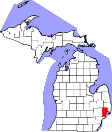 | |
| Villages | ||
| Charter townships | ||
| General law townships | ||
| Unincorporated community |
| |
| Footnotes | ‡This populated place also has portions in an adjacent county or counties | |
| Topics |  | |
|---|---|---|
| Detroit | ||
| Municipalities over 80,000 | ||
| Municipalities 40,000 to 80,000 | ||
| Cultural enclaves | ||
| Satellite cities | ||
| Counties in MSA | ||
| Counties in CSA | ||
Coordinates: 42°29′44″N 82°54′1″W / 42.49556°N 82.90028°W