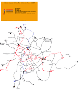
Trams in Brussels
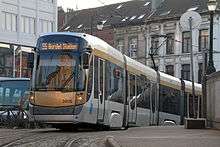 A Bombardier T3000 in Brussels, 2010. | |||||||||
| Operation | |||||||||
|---|---|---|---|---|---|---|---|---|---|
| Locale | Brussels, Belgium | ||||||||
| Routes | 20 (2013)[1] | ||||||||
| Owner(s) | Brussels-Capital Region | ||||||||
| Operator(s) | STIB/MIVB | ||||||||
| Infrastructure | |||||||||
| Track gauge | 1,435 mm (4 ft 8 1⁄2 in) | ||||||||
| Propulsion system(s) | Electricity | ||||||||
| Electrification | 600 V DC | ||||||||
| Statistics | |||||||||
| Route length | 138.9 km (86.3 mi)[2] | ||||||||
| Passengers (2012) | 123.5 million[3] | ||||||||
| |||||||||
| |||||||||
| |||||||||
| |||||||||
| |||||||||
| Website | STIB/MIVB (English) | ||||||||
The Brussels tram (or streetcar) system is a transport system in Brussels, Belgium. It is the 16th largest tram system in the world by route length, and in 2012 carried some 123.5 million passengers.[3] In 2016, the Brussels tram system consists of 17 tram lines[4] (three of which – lines T3, T4 and T7 – qualify as premetro lines).[5] As of 2011, the tram system's total route length was 138.9 km (86.3 mi),[2] making it one of the larger tram networks in Europe. Its development has demonstrated many of the quandaries that face local public transport planners. The Brussels tram system also has a number of interesting peculiarities.
History

The first horse-drawn trams were introduced in Brussels in 1869, running from the Porte de Namur to the Bois de la Cambre.[6] The first electric tramway came to Brussels in 1894.[6]
Intermodal integration
The system exists in a somewhat unusual local government context, because Brussels is a self-governing region, as an enclave within Flanders, although only some 3.3 kilometres from Wallonia at the closest point. This means that three-way deals are necessary between Brussels’ own STIB/MIVB, Flanders’ De Lijn and Wallonia’s TEC.
STIB sees itself as a provider of mobility rather than just public transport, and has a 49% share in the Cambio carsharing franchise. The Brussels conurbation — 19 municipalities plus adjoining commuter belt — is also served by a fairly dense network of main-line trains. The MOBIB contactless smart card can be used on buses, trams and the metro, and is gradually being extended to other modes, although it is not yet accepted by De Lijn or TEC. A simple tariff system permits unlimited changes with a one-hour period for €2.50 when bought from the driver, €2.10 from a ticket machine.
Ridership has been rising, and user-friendly features that have grown up through custom and practice help this. For instance, passengers open the doors by pressing a green strip on the central pole (in PCC trams) or an illuminated button (on Flexity trams), and drivers usually make a point of waiting for latecomers. However, overcrowding at rush hours and at weekend is common. Fare-dodging is reputedly quite high, despite periodic enforcement campaigns, and this is being addressed by the installation of ticket barriers in all metro stations. From 2013, the obligation to check out of as well as into the system is being progressively introduced.
Routes

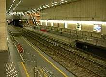
As of 2013, there are 19 tram routes,[1] totaling 138.9 kilometres (86.3 mi),[2] and serving most parts of the city, including the two partial ring routes (T7 and T92). The tram routes have a very varied feel, including street running through narrow streets in working-class districts (lines T81 and T83), cobbled central reservation, reserved track through parkland and woods (T44), signal-controlled running in tunnels (the premetro lines T3 and T4 in the North–South Axis, and T7), and short stretches in cutting (the old route T18, closed in 2007). Almost all trams are double-ended and all are double-sided, and while some stub termini remain (T4, T51, T97), most have loops. The route pattern shows some notable gaps, particularly along major radial routes, because these were originally served by the national network of buurtspoorwegen/tramways vicinaux. These had a gauge of one metre, rather than the Brussels standard gauge, and so the tracks could not easily be taken over when the lines were progressively closed from the 1960s onwards.
The complementary routing of vicinal and urban tracks and the replacement of key lines by metro has led to some peculiar track layouts, for instance at the Barrière de St-Gilles/Bareel St-Gillis. Though all seven roads at this circular junction originally had tram lines, only three of the original seven remain.[7] To negotiate a sharp turn, the old route T18 (closed 1 July 2007) had to make a 270-degree turn on its journey away from the city centre, looping round and crossing its own path.
Under the South station, the premetro and metro tracks swap from running on the right to running on the left where they run parallel to provide cross-platform interchange between the two lines. This serves no apparent purpose, but may be because main line trains in Belgium run on the left. Trams cross back to the right under Place Bara but the metro stays on the left as far as the Roi Baudouin terminus.
There is no tram priority at traffic lights, but the track layout is used to avoid hold-ups on route T92 at the Ma Campagne and Place Janson crossroads, which lie 300 metres from each other on the Chaussée de Charleroi/Charleroisesteenweg. There is lateral space for only one track in a raised central reservation, and the rails swerve to the left approximately 100 metres in front of the junction so that cars can queue in the right-hand lane.
Between 2006 and 2009, a phased transformation of the network took place, with the aim of improving regularity and relieving overcrowding. The premetro service between North station and Albert was restructured with fewer lines passing through it, but at more regular intervals. These routes use the new longer Bombardier trams. The major part of the North-South Axis (from Lemonnier to Rogier) is now used only by lines T3 and T4 during the day, branded Chrono. Tram line T55 from Schaerbeek (north of Brussels) that used to use the North-South Axis now terminates at Rogier. The old line T52 was replaced by line T3 in the north (from Brussels-South railway station to Thomas and from Van Praet to Esplanade), T82 (from Drogenbos to Lemonnier) and T32 in the south. The old tram line T56 was also eliminated.
A previously implemented part of the plan was the creation of line T25 in April 2007. Line T25 goes from Rogier to the Boondael/Boondaal railway station following the route of the ex-line T90 from Rogier to Buyl, then leaves the outer ring towards the Université Libre de Bruxelles campus of Solbosch.
On March 14, 2011, old lines T23 and T24 were merged to create the new eastern semicircular premetro line T7 which runs almost entirely in its own right of way from Heizel/Heysel in the north to Vanderkindere in the south.
High-floor and low-floor trams

The development of the system is being pulled in two contradictory directions – towards low-floor street-running trams and high-floor underground railway. This has led to some conflicting decisions. The standard trams — still "PCC"s from the 1950s and 60s — have been followed by the specially designed "T2000" low-floor model and, at the end of 2005, by a variant of the off-the-shelf "Flexity Outlook" from Bombardier (3000 series), and, at the end of 2006, by an even longer version of the same family (4000 series).
On some of the busiest routes, the convenience of the low floor is lost because of the anomalies caused by the hesitant upgrade of tram to metro. The city has four heavy metro lines and three stretches of premetro or underground tram. The premetro tunnels have been built to allow for eventual upgrade to heavy metro, so most of the platform is high, and is connected to the street (at least in the upward direction) by escalator. At some stations lifts have been installed, but there is a cutout section taking the level down to one foot above ground to board the trams. The three steps this entails make life difficult for passengers with baby buggies or suitcases, even though the new low-floor trams are accessible to wheel-chair users. To get around this last barrier to mobility, an experimental ramp was installed in 2009 at Parvis de St-Gilles/St-Gillis Voorplein.
Livery

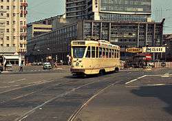
Brussels trams have known several liveries. In the beginning of the 20th century, those operated by the Tramways Bruxellois were dark green, by the Chemins de Fer Economiques chocolate. The two companies merged in the 1920s, whereupon a standard livery of primrose yellow was adopted which lasted (with some minor changes in the trimmings) until the mid-1990s when a brighter shade of yellow was adopted.
A profound change in livery came in 2006 with the adoption of the so-called art nouveau livery of silver and light brown on the new 3000 and 4000 vehicles and is gradually being applied to the whole fleet.
2010 Vancouver Olympics
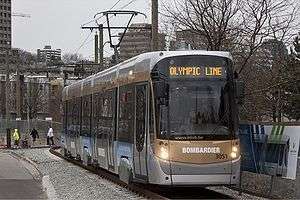
From January 21 to March 21, 2010, a demonstration streetcar project, known as the Olympic Line, at Vancouver, BC, Canada, utilised cars 3050 & 3051 (Bombardier Flexity Outlook) on a Vancouver Downtown Historic Railway 1.8 km track.
Heritage trams
The system exists in happy symbiosis with an active heritage operation based at Woluwe depot, and privately hired trams have free access to the tracks. Trams that still collect their current through trolley poles rather than pantographs are normally restricted to the scenic line from Cinquantenaire park via Woluwe to Tervuren, which is run with the help of volunteers from the preservation society MTUB (Museum of Brussels Urban Transport). This runs at weekends from April to October; occasionally, such as on the Belgian national holiday July 21, these trams appear in the city centre, where the line in the "Koningsstraat/Rue Royale" is trolleypole-enabled.
Several trams have been sent to the United States. Tram 7037 is in San Francisco operating on line F, surreally repainted in the blue-and-white livery of Zürich. Tram 1504 is at the Trolley Museum of New York and 1511 is at Old Pueblo Trolley. An 4-axle PCC is also awaiting restoration at the Ontario St shed of Vancouver's Downtown Historic Railway.
Route list
Tram routes as of 31 August 2015:
- 3: Esplanade — Churchill
- 4: Gare du Nord / Noordstation – Stalle P
- 7: Heysel / Heizel — Vanderkindere
- 19: De Wand — Groot-Bijgaarden
- 25: Rogier – Boondael railway station
- 32: Da Vinci – Drogenbos Château / Drogenbos Kasteel Only in the evening.
- 39: Montgomery – Ban Eik
- 44: Montgomery — Tervuren Station
- 51: Stade / Stadion — Van Haelen
- 55: Da Vinci — Rogier
- 62: Eurocontrol – Cimetière de Jette / Kerkhof van Jette
- 81: Marius Renard — Montgomery
- 82: Berchem Station — Drogenbos Château / Drogenbos Kasteel
- 92: Schaerbeek Gare / Schaarbeek Station – Fort-Jaco
- 93: Stade / Stadion – Legrand
- 94: Louise / Louiza – Musée du tram / Trammuseum
- 97: Louise / Louiza — Dieweg
Stricken-out numbers represent partial services (they do not go up to the end of the line). Only regular services are shown in this list.
Statistics
The sources of these statistics come from either 2011[8] or 2012:[3]
- Passenger journeys: 123.5 million per year[3]
- Length of tram line (double-track): 138.9 km (86.3 mi), of which 77.8 km (48.3 mi) are in dedicated lanes (i.e. own right-of-way) and 12.1 km (7.5 mi) of which are in tunnels or underground[2]
- Average distance between stops (in meters): 395 m[8]
- Vehicle-kilometres travelled: 12.19 million[8]
- Target speed in winter: 16.6 km/h[8]
- No of trams: 349, of which 37.8% accessible[8]
- No. of depots: 6, with 2 workshops[8]
See also
References
| Wikimedia Commons has media related to Trams in Brussels. |
- Tramways and Urban Transit, July 2005, published by the Light Rail Transit Association. ISSN 1460-8324
- (French) Tram2000 – a monthly magazine
Footnotes
- 1 2 "STIB - Timetables and real time". STIB/MIVB. 2013. Retrieved 2013-09-15.
- 1 2 3 4 "Activity Report 2011 - Figures & statistics '11" (PDF). STIB/MIVB. p. 08. Retrieved 2013-09-15.
- 1 2 3 4 "STIB - Key Figures". STIB. 2013. Retrieved 2013-09-15.
- ↑ "STIB simplifies its online route planner". Brussels Smart City. 2016-03-18. Retrieved 2016-03-26.
- ↑ Geoffroy Fabre (2014-03-19). "Une station fantôme au secours du futur Métro Nord de la STIB". RTBF. Retrieved 2014-05-09.
- 1 2 "STIB - La STIB de 1890 à 1953" [STIB - STIB from 1869 to 1953] (in French). STIB. 2013. Retrieved 2013-09-15.
- ↑ Map from September 1949 by J.C. Gillham inside back cover of Brussels - A Tramway Reborn 1945-2008, Geoffrey Skelsey & Yves-Laurent Hansart, Light Rail Transit Association, Peterborough UK, 2008, ISBN 978-0-948106-36-1
- 1 2 3 4 5 6 "Activity Report 2011 - Figures & statistics '11" (PDF). STIB/MIVB. Retrieved 2013-09-15.
External links
- Official English site
- Official English system map
- Brussels Studies 7: The direct cost and geography of Brussels mass transport’s operating delays, Frédéric Dobruszkes & Yves Fourneau, 24 May 2007
- Brussels Studies 20: The (in)efficiency of trams and buses in Brussels: a fine geographical analysis, Xavier Courtois & Frédéric Dobruszkes, 27 June 2008
