Ujjain
| Ujjain उज्जैन Ujain, Ujjayini, Avanti, Avantika, Avantikapuri | |
|---|---|
| City | |
|
Ujjain City | |
| Nickname(s): The City of Temples | |
 Ujjain  Ujjain Location in India | |
| Coordinates: 23°10′N 75°47′E / 23.17°N 75.79°ECoordinates: 23°10′N 75°47′E / 23.17°N 75.79°E | |
| Country |
|
| State | Madhya Pradesh |
| Region | Malwa |
| District | Ujjain |
| Government | |
| • Body | Ujjain Municipal Corporation |
| • Mayor | Meena Jonwal (BJP) |
| • Municipal Commissioner | Devendra Nigam |
| Area[1] | |
| • Total | 152 km2 (59 sq mi) |
| Population (2011) | |
| • Total | 515,215 |
| • Density | 3,400/km2 (8,800/sq mi) |
| Languages | |
| • Official | Hindi, |
| • Other | Malvi |
| Time zone | IST (UTC+5:30) |
| PIN | 456001 to 456010 |
| Telephone code | 0734 |
| Vehicle registration | MP-13 |
| Climate | Cfa (Köppen) |
| Precipitation | 900 millimetres (35 in) |
| Avg. annual temperature | 24.0 °C (75.2 °F) |
| Avg. summer temperature | 31 °C (88 °F) |
| Avg. winter temperature | 17 °C (63 °F) |
| Website |
ujjain |
Ujjain (/uːˈdʒeɪn/; ![]() listen ) is the largest city in Ujjain district of the Indian state of Madhya Pradesh. It is the administrative centre of Ujjain district and Ujjain division.[1]
listen ) is the largest city in Ujjain district of the Indian state of Madhya Pradesh. It is the administrative centre of Ujjain district and Ujjain division.[1]
An ancient city situated on the eastern bank of the Kshipra River, Ujjain was the most prominent city on the Malwa plateau of central India for much of its history. It emerged as the political centre of central India around 600 BCE. It was the capital of the ancient Avanti kingdom, one of the sixteen mahajanapadas. It remained an important political, commercial and cultural centre of central India until the early 19th century, when the British administrators decided to develop Indore as an alternative to it. Ujjain continues to be an important place of pilgrimage for Shaivites, Vaishnavites and followers of Shakta.[2]
Ujjain has been selected as one of the hundred Indian cities to be developed as a smart city under PM Narendra Modi's flagship Smart Cities Mission.[3]
History
Excavations at Kayatha (around 26 km from Ujjain) have revealed chalcolithic agricultural settlements dating to around 2000 BCE.[4] Chalcolithic sites have also been discovered at other areas around Ujjain, including Nagda, but excavations at Ujjain itself have not revealed any chalcolithic settlements. H. D. Sankalia theorized that the chalcolithic settlements at Ujjain were probably destroyed by the Iron Age settlers.[5]
According to Hermann Kulke and Dietmar Rothermund, Avanti, whose capital was Ujjain, "was one of the earliest outposts in central India" and showed signs of early urbanisation around 700 BCE.[6] Around 600 BCE, Ujjain emerged as the political, commercial and cultural centre of Malwa plateau.[7]
The ancient walled city of Ujjain was located around the Garh Kalika hill on the bank of river Kshipra, in the present-day suburban areas of the Ujjain city. This city covered an irregular pentagonal area of 0.875 km2. It was surrounded by a 12 m high mud rampart. The archaeological investigations have also indicated the presence of a 45 m wide and 6.6 m deep moat around the city.[8] According to F. R. Allchin and George Erdosy, these city defences were constructed between 6th and 4th centuries BCE.[9] Dieter Schlingloff believes that these were built before 600 BCE.[8] This period is characterised by structures made of stone and burnt-brick, tools and weapons made of iron, and black and red burnished ware.[9]
According to the Puranic texts, a branch of the legendary Haihaya dynasty ruled over Ujjain.[10][11]
In the Mauryan period, Ujjain remained the administrative centre of the region. From this period, Northern Black Polished Ware, copper coins, terracotta ring wells and ivory seals with Brahmi text have been excavated.[9] During the reign of his father Bindusara, Ashoka served as the viceroy of Ujjain.[12] Ujjain was subsequently controlled by a number of empires and dynasties, including the Shungas, the Western Satraps, the Satavahanas, the Guptas and the Paramaras. The Paramaras shifted the region's capital from Ujjain to Dhar.[7]
Ujjain was an important literary centre of ancient India, called Adyapeetha, or foundation of Sanskrit learning, ethics, knowledge, science and art, and has been called, "Swarna Sringa", in local parlance, due to the golden towers of the many temples in this temple city.[13] Raja Bharthari wrote his great epics, Virat Katha, Neeti Sataka, the love story of Pradyot Princess Vasavadatta and Udayan in Ujjayini, as the city was called during his times. The writings of Bhasa are set in Ujjain, and he probably lived in the city.[14] Kalidasa also refers to Ujjain multiple times, and it appears that he spent at least a part of his life in Ujjain.[15] Mrichchhakatika by Shudraka is also set in Ujjain.[16] Ujjain also appears in several stories as the capital of the legendary emperor Vikramaditya. Somadeva's Kathasaritsagara (11th century) mentions that the city was created by Vishwakarma, and describes it as invincible, prosperous and full of wonderful sights.[17]
During medieval times, Ujjain ultimately came under the Islamic rule, like other parts of north-central India. In 1235 CE, Iltutmish of Delhi Sultanate plundered the city, and destroyed its temples.[7] However, Ujjain continued to be an important city of the region. As late as during the times of the Mughal vassal Jai Singh II (1688-1743), who constructed a Jantar Mantar in the city, Ujjain was the largest city and capital of the Malwa Subah.[18]
During the 18th century, the city briefly became the capital of Scindia state of the Maratha confederacy, when Ranoji Scindia established his capital at Ujjain in 1731. But his successors moved to Gwalior, where they ruled the Gwalior State in the latter half of the 18th century. The struggle of supremacy between the Holkars of Indore and Scindias (who ruled Ujjain) led to rivalry between the merchants of the two cities.[19] On 18 July 1801, the Holkars defeated the Scindias at the Battle of Ujjain. On 1 September, Yashwantrao Holkar entered the city, and demanded a sum of 15 lakh rupees from the city. He received only 1/8th of this amount; the rest was pocketed by his officers. A force sent by Daulat Scindhia later regained control of Ujjain.[20] After both Holkar and Scindias accepted the British suzerainty, the British colonial administrators decided to develop Indore as an alternative to Ujjain, because the merchants of Ujjain had supported certain anti-British people. John Malcolm, the British administrator of Central India, decided to reduce the importance of Ujjain "by transferring a great part of that consequence it now enjoys to the Towns of Indore and Rutlam cities, which are and will continue more under our control."[19]
After the independence India, Ujjain became a part of the Madhya Bharat state. In 1956 Madhya Bharat was fused into the State of Madhya Pradesh.
Geography
Ujjain is located in the west-central part of India, and is north of the upper limit of the Vindhya mountain ranges. Located on the Malwa plateau, it is higher than the north Indian plains and the land rises towards the Vindhya Range to the south. Ujjain's co-ordinate are 23°10′N 75°46′E / 23.167°N 75.767°E with average elevation of 494m metres (1620 ft).[21] Region is an extension of the Deccan Traps, formed between 60 and 68 million years ago[22][23] at the end of the Cretaceous period. The city is on the river bank of Shipra which falls into nearby flowing Chambal.
Demographics

According to the 2011 census, Ujjain has a population of 515,215, 264,871 of whom were male and 250,344 female. The sex ratio is 945 per 1000 males, and the child sex ratio is 929 girls per 1000 boys. The city has 58,972 children under the age of six. There were 30,573 boys and 28,399 girls, which formed 11.45% of the total population of the city.[24]
The total literates in the city were 385,193, of whom 210,075 were males and 175,118 were females. The average literacy rate of the city is 84.43 percent. Male and female literacy were 89.66 and 78.90 percent, respectively.[24]
Government and jurisdiction
Most of the regions surrounding the city are administered by the Ujjain Municipal Corporation (UMC). The city is administered by Divisional Commissioner and Collectorate Office as welll as the Mayor. They are responsible for Tthe own and Country Planning Department, Forest Department, Public Health Engineering, Public Works Department and MP Electricity Board.[25][26]
Ujjain has been a metropolitan municipality with a mayor-council form of government. Ujjain Municipal Corporation (UMC) was established in 1956 under the Madhya Pradesh Nagar Palika Nigam Adhiniyam. The UMC was established in 1886 as Nagar Palika, but the Municipal Corporation of Ujjain was declared on a par with the Gwalior Municipal Corporation. The UMC is responsible for public education, correctional institutions, libraries, public safety, recreational facilities, sanitation, water supply, local planning and welfare services. The mayor and councillors are elected to five-year terms.[27] [28]
Ujjain Development Authority, also known as UDA, is the urban planning agency serving Ujjain. Its headquarters is located in Bharatpuri area of Ujjain. It was established under the Madhya Pradesh Town and Country Planning Act, 1973.[29]
Ujjain Lok Sabha constituency is one of the 29 Lok Sabha constituencies in Madhya Pradesh state in central India. This constituency came into existence in 1951 as one of the 9 Lok Sabha constituencies in the erstwhile Madhya Bharat state. It is reserved for the candidates belonging to the Scheduled Castes since 1966. This constituency covers the entire Ujjain district and part of Ratlam district. Currently, Dr. Chintamani Malviya of the Bharatiya Janata Party is member of parliament who won in the Indian general elections, 2014.[30]
Education
University
College
- Mahakal Institute of Technology
- Ujjain Engineering College
- Pt. Jawaharlal Nehru Institute of Business Management
- Ruxmaniben Deepchand Gardi Medical College
Schools
The city's government and private schools include:
- St Paul's Higher Secondary School
- Takshshila Junior College
- Ujjain Public School
- St. Mary's Convent School
- Central School, Nagziri
- Mahadji Scindia Public School, Chamunda Mata
- Christu Jyoti Convent Senior Secandory School
- Carmel Convent Sr. Sec. School
- Saraswati Vidhya Mandir Marutiganj, Ujjain
Industry
The Government of Madhya Pradesh has allotted 1,200 acres for the development of an industrial area on the Dewas-Ujjain Road near Narwar village. Originally named "Vikramaditya Knowledge City", the area was envisaged as an educational hub. Due to diminished investment prospects, it was renamed to "Vikram Udyog Nagari" ("Vikram Industrial City"). As of 2014, the government has conceptualised it as a half-industrial, half-educational area. The stakeholders in the project include the state government and the Delhi Mumbai Industrial Corridor (DMIC) Trust.[31]
Culture
Ujjain is considered one of the holiest cities in India, and is a popular pilgrimage centre.[32][33] Some of the notable sacred places in the city include:
- Mahakaleshwar Jyotirlinga, an ancient temple that was destroyed by Iltutmish and then restored by the Scindias of Gwalior
- Kal Bhairav temple
- ISKCON temple
- Chintaman Ganesh temple
- Gopal Mandir, built by Sawai Jai Singh of Jaipur
- Chamunda Mata temple, Ujjain[34]
Other historic places in Ujjain include:
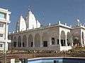
 Mahakaleshwar Jyotirlinga is the city's most visited temple.
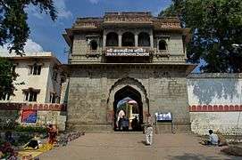 Kal Bhairav temple, where liquor is offered to the city's guardian deity
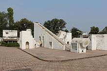
- Ved Shala or Jantar Mantar
 ISKCON temple of Ujjain
Simhastha
The Ujjain Simhastha is a mass Hindu pilgrimage, and one of the fairs recognised as Kumbh Melas. During the Simhastha, Hindus gather to bathe in a sacred river.[35] At Ujjain, it is held once every 12 years, on the banks of Kshipra river. It is also known as Simhastha, when it falls during Jupiter's stay in Leo of Simha. The latest Simhastha was held in Ujjain from 22 April 2016 to 21 May 2016.[36]
Transport
Airport
Ujjain does not have any airport but has an airstrip on Deaws road which is used for air transport purposes.[37] In 2013, the Government of Madhya Pradesh started a Ujjain-Bhopal air services as a joint venture with Ventura Airconnect. Due to very low booking, the ambitious project was scrapped. The main reason for the failure of the plan was improper timing. [38] The nearest airport is the Devi Ahilyabai Holkar International Airport at Indore (62 km).
Railway

Ujjain Junction is the main railway station of Ujjain, and it is directly or indirectly well-connected to all the major railway stations in India.[39] It lies on the Ratlam–Bhopal, Indore–Nagda and Guna–Khandwa route. To the west it is connected to Ratlam Junction, to the north it is connected with Nagda Junction, to the east it is connected with Maksi Junction, Bhopal Junction, and to the south it is connected to Indore Junction BG, Dewas Junction.[40][41]
There are five railway stations in the Ujjain city and its suburbs:
| Station name | Station code | Railway zone | Total platforms |
|---|---|---|---|
| Ujjain Junction | UJN | Western Railway | 8 |
| Chintaman Ganesh | CNN | Western Railway | 1 |
| Matana Buzurg (abandoned) | MABG | Western Railway | 2 |
| Pingleshwar | PLW | Western Railway | 2 |
| Vikramnagar | VRG | Western Railway | 2 |
Road

Dewas Gate Stand and Nana Kheda Bus Stand are the two bus stands in the city that provide service to destinations located in the states. A large number of state run private buses are available for Ahmedabad, Jaipur, Ajmer, Khajuraho, Indore, Bhopal, Pune, Mumbai Kota, Mandu, Jhalawar and various other locations. The city has a well connected road network including Indore Road, Badnagar Road, Dewas Road and Maksi Road. There are two state highways; 18 connects to Ahmedabad, and 27 connects to Indore.[42][43][44][45]
Other important regional highways passing through the city are:
- Indore – Ujjain Road via SH 27
- Kota / Agar – Ujjain Road via SH 27
- Bhopal / Dewas – Ujjain Road via SH 18
- Ratlam / Barnagar – Ujjain Road via SH 18
- Jaora / Nimach – Ujjain Road via SH 17
- Maksi – Ujjain Road (Connects to NH 3)
Local transport
Ujjain depends on an extensive network of auto rickshaws, city busses, private taxis and Tata Magic, that operate throughout the city, connecting one part with another. UMC has recently introduced city buses with a public private partnership project as the city was identified urban agglomerations with less than 1 million population under the Jawaharlal Nehru National Urban Renewal Mission.[46][47]
Sports
Cricket is one of the most popular sports in the city. Ujjain is also home to the Ujjain Divisional Cricket Association which is affiliated to BCCI. The city does not have any stadiums, but hosted Ranji Trophy matches at Pipe Factory Ground in 1977 and 1980.[48]
Kite flying is another popular activity in the city around Makar Sakranti.[49]
There are a few playing fields in Ujjain:
- Madhav College Ground
- Mahakal Institute of Technology Ground[50]
- Ujjain International Stadium[51]
- Vikram University Ground[52]
Health care
The city has a government hospital, TB hospital and Ruxmaniben Deepchand Gardi Medical College.
Notable people
Notable people who were born or lived in Ujjian include:
References
- 1 2 "District Census Handbook - Ujjain" (PDF). Census of India. p. 12,22. Retrieved 6 December 2015.
- ↑ Jacobsen, Knut A. (2013). Pilgrimage in the Hindu Tradition: Salvific Space. Routledge. p. 128. ISBN 978-0-41559-038-9.
- ↑ http://www.firstpost.com/business/why-only-98-cities-instead-of-100-announced-all-questions-answered-about-smart-cities-project-2410576.html
- ↑ P. K. Basant (2012). The City and the Country in Early India: A Study of Malwa. Primus. pp. 78–81. ISBN 9789380607153.
- ↑ Pranab Kumar Bhattacharyya 1977, pp. 1-2.
- ↑ Kulke, Hermann; Rothermund, Dietmar (2004). A History of India. Psychology Press. pp. 50–51. ISBN 978-0-41532-920-0.
- 1 2 3 Trudy Ring; Noelle Watson; Paul Schellinger, eds. (2012). Asia and Oceania: International Dictionary of Historic Places. Routledge. p. 835. ISBN 9781136639791.
- 1 2 Dieter Schlingloff (2014). Fortified Cities of Ancient India: A Comparative Study. Anthem. pp. 21–22. ISBN 9781783083497.
- 1 2 3 F. R. Allchin and George Erdosy (1995). The Archaeology of Early Historic South Asia: The Emergence of Cities and States. Cambridge University Press. pp. 134–136. ISBN 9780521376952.
- ↑ Kailash Chand Jain (1972). "Malwa Through the Ages, from the Earliest Times to 1305 A.D". Motilal Banarsidass. p. 90. ISBN 9788120808249.
- ↑ Ahmad, S. H., Anthropometric measurements and ethnic affinities of the Bhil and their allied groups of Malwa area., Anthropological Survey of India,1991, ISBN 81-85579-07-5
- ↑ William Woodthorpe Tarn (2010). The Greeks in Bactria and India. Cambridge University Press. p. 152. ISBN 9781108009416.
- ↑ Ujjayini Mahakaleshwar Jyotirling
- ↑ Martin Banham (1995). The Cambridge Guide to Theatre. Cambridge University Press. p. 103. ISBN 9780521434379.
- ↑ Arthur W. Ryder (2014). Translations of Shakuntala: And Other Works. The Floating Press.
- ↑ Farley P. Richmond (1993). Indian Theatre: Traditions of Performance. Motilal Banarsidass. pp. 55–57. ISBN 9788120809819.
- ↑ N. M. Penzer, ed. (1924). "Book XVIII: Vishamasila". The ocean of story. IX. Translated by C. H. Tawney. Chas J. Sawyer. p. 2.
- ↑ Virendra Nath Sharma (1995). Sawai Jai Singh and His Astronomy. Motilal Banarsidass. p. 212.
- 1 2 Amar Farooqui (1998). Smuggling as Subversion: Colonialism, Indian Merchants, and the Politics of Opium, 1790-1843. Lexington. pp. 62–63.
- ↑ R.S. Chaurasia (2004). History of the Marathas. Atlantic. p. 61. ISBN 9788126903948.
- ↑ http://dateandtime.info/citycoordinates.php?id=1253914
- ↑ "Geochronological Study of the Deccan Volcanism by the 40Ar-39Ar Method". Archived from the original on 2006-02-25.
- ↑ The Deccan beyond the plume hypothesis
- 1 2 "District Census Handbook: Ujjain" (PDF). Directorate of Census Operations, Madhya Pradesh. Retrieved 24 November 2015.
- ↑ "Welcome to official website of District Administration Ujjain (M.P.) India". ujjain.nic.in. Retrieved 2015-08-21.
- ↑ "BJP clean sweeps in Madhya Pradesh civic polls - The Times of India". timesofindia.indiatimes.com. Retrieved 2015-08-21.
- ↑ "Welcome to official website of District Administration Ujjain (M.P.) India". ujjain.nic.in. Retrieved 2015-08-21.
- ↑ "Welcome to official website of District Administration Ujjain (M.P.) India". ujjain.nic.in. Retrieved 2015-08-21.
- ↑ "Information at a glance" (PDF). MPurban. Retrieved December 12, 2015.
- ↑ "Constituencywise-All Candidates". Eciresults.nic.in. Retrieved 2014-05-17.
- ↑ Ujjain's 'Knowledge City' renamed 'Vikram Udyog Nagari'
- ↑ Brajesh Kumar (2003). Pilgrimage Centres of India. Diamond. p. 105. ISBN 978-81-7182-185-3.
- ↑ Plunkett, Richard. Central India. Lonely Planet, 2001. ISBN 1-86450-161-8
- ↑ Chamunda Mata temple, Ujjain
- ↑ "Kumbha Mela - The world's most massive act of faith". archaeologyonline.net. 14 September 2015.
- ↑ Ramendra Singh (18 July 2015). "CM Chouhan's invitation for Ujjain Simhastha". The Times of India.
- ↑ "List of airports in Madhya Pradesh, India (excluding heliports and closed airports)". Our Airports.
- ↑ Ujjain-Bhopal air services fail to get off to a flying start
- ↑ Agam Gupta (September 2013). Unfolding Faith: A Journey to the Kumbh. Partridge Publishing. pp. 31–. ISBN 978-1-4828-1213-8.
- ↑ Trains at Ujjain
- ↑
- ↑ UDA
- ↑
- ↑
- ↑
- ↑ Jawaharlal Nehru National Urban Renewal Mission
- ↑ Indian Express
- ↑ Ground Info
- ↑ Kite flying, holy dips mark Sankranti in Ujjain, Indore
- ↑ Mahakal Institute of Technology Ground
- ↑ Kisan Sammelan to be held at Nanakheda Stadium
- ↑ Cricketarchive
Bibliography
- Rahman Ali; Ashok Trivedi; Dhirendra Solanki (2004). Buddhist remains of Ujjain region: excavations at Ṣodañga. Sharada Pub. House. ISBN 978-81-88934-15-7.
- Dipak Kumar Samanta (1996). Sacred Complex of Ujjain. D.K. Printworld. ISBN 978-81-246-0078-8.
- Hunter, Cotton, Burn, Meyer. "The Imperial Gazetteer of India", 2006. Oxford, Clarendon Press. 1909.
- Dongray, Keshav Rao Balwant (1935). Ujjain. Alijar Darbar Press, Gwalior.
- Pranab Kumar Bhattacharyya (1977). Historical Geography of Madhya Pradesh from Early Records. Motilal Banarsidass. p. 275. ISBN 978-0-8426-9091-1.
External links
| Wikimedia Commons has media related to Ujjain. |
| Wikisource has the text of the 1911 Encyclopædia Britannica article Ujjain. |
- Official website of Ujjain Municipal Corporation
- Official website of Ujjain district
- Official website of Ujjain Kumbh Mela