Westmont, Illinois
| Westmont | |
|---|---|
| Village | |
 | |
| Nickname(s): "Whiskey Hill", "Mont o' the West" | |
| Motto: "The Progressive Village" | |
 Location in DuPage County and the state of Illinois. | |
| Coordinates: 41°47′40″N 87°58′35″W / 41.79444°N 87.97639°WCoordinates: 41°47′40″N 87°58′35″W / 41.79444°N 87.97639°W | |
| Country |
|
| State | Illinois |
| County | DuPage |
| Township | York, Downers Grove |
| Incorporated | 1921 |
| Government | |
| • Type | Mayor-trustee |
| • Mayor | Ron Gunter |
| Area | |
| • Total | 5.14 sq mi (13.3 km2) |
| • Land | 5.03 sq mi (13.0 km2) |
| • Water | 0.11 sq mi (0.3 km2) 2.14% |
| Population [1] | |
| • Total | 25,021 |
| • Density | 4,900/sq mi (1,900/km2) |
| Up 15.67% from 1990 | |
| Standard of living | |
| • Per capita income | $26,394 (median: $51,422) |
| • Home value | $200,814 (median: $180,200 (2000)) |
| ZIP code(s) | 60559 |
| Area code(s) | 630 and 331 |
| Geocode | 80645 |
| Website |
www |
| Demographics (2000)[2] | |||
|---|---|---|---|
| White | Black | Hispanic | Asian |
| 78.02% | 6.38% | 6.98% | 11.95% |
| Islander | Native | Other | |
| 0.00% | 0.13% | 2.41% | |
Westmont is a village in DuPage County, Illinois, United States. Westmont is a community of 5.03 square miles in area. Westmont had a 2000 population of 24,554, a partial special census was conducted 2007 resulting in a population of 26,211, and the census of 2010 put the population at 24,685. It is located approximately 18 miles (29 km) west of the Chicago Loop in the southeastern portion of DuPage County.[3]
History
The area known as Westmont was inhabited by the Potawatami until the year 1833. After several failed attempts by the U.S. government to persuade the Native Americans to move from the area, in 1833, the Native Americans agreed under coercion to vacate their land for nominal payment.[4]
The development of the Illinois-Michigan Canal, authorized by the State of Illinois in the 1820s but delayed in construction until the 1830s, contributed to Westmont's early growth.[4] When the economic Panic of 1837 halted canal construction, many of the workers turned to farming, and agriculture became the major occupation, with produce sold in nearby Chicago. The area around Westmont became one of the most prosperous sections of the state.
In order to transport agricultural products into the city of Chicago, construction of a plank road originating in Chicago began in 1840. The plank road was placed over the nine-mile (14 km) swamp separating Chicago and the area that became Westmont, and reached Naperville, Illinois by 1851.[4] Today, this roadway is known as Ogden Avenue (U.S. Route 34).
The plank road soon became inadequate; in 1858, local incorporated towns and villages petitioned the Chicago, Burlington and Quincy Railroad to build a branch line from Chicago to Aurora, Illinois that would pass through their towns.[4] The railroad line was approved, with the first train in 1864. "Greg’s Station," from which Westmont developed, was a stop to load agricultural and dairy products. The town transitioned gradually from an agricultural community to a commuter community, with the early growth and development centered around the railroad station.
In the early 1900s, plats for the Village of Westmont were laid out and roads were dedicated; incorporation, decided by only a narrow margin, followed in 1921. Westmont was officially incorporated on November 10, 1921; Vince Pastor served as the first president of the Village Board.[4]
The Village did not encourage concentrated commercial or industrial growth until the 1950s, with the development of some light service companies, industrial firms, and wholesaling firms. However, it was not until the 1960s and 1970s the Westmont began to grow in earnest; Westmont High School did not open until 1974. New subdivisions and multiple family housing units led to the tripling of the population.
Notable people
- Kira Salak, writer and journalist (National Geographic)
- Muddy Waters, musician, considered the father of Chicago blues; lived for a decade and died in Westmont
- Ty Warner, industrialist and inventor of Beanie Babies
Geography
Westmont is located at 41°47′40″N 87°58′35″W / 41.79444°N 87.97639°W (41.794480, -87.976433).[5] It is bounded on the north by the Village of Oak Brook, on the east by the Village of Clarendon Hills, on the south by the City of Darien and on the west by the Village of Downers Grove. It is nearly wholly within Downers Grove Township.
According to the 2010 census, Westmont has a total area of 5.136 square miles (13.30 km2), of which 5.03 square miles (13.03 km2) (or 97.94%) is land and 0.106 square miles (0.27 km2) (or 2.06%) is water.[6]
Demographics
| Historical population | |||
|---|---|---|---|
| Census | Pop. | %± | |
| 1930 | 2,733 | — | |
| 1940 | 3,044 | 11.4% | |
| 1950 | 3,402 | 11.8% | |
| 1960 | 5,997 | 76.3% | |
| 1970 | 8,832 | 47.3% | |
| 1980 | 17,353 | 96.5% | |
| 1990 | 21,228 | 22.3% | |
| 2000 | 24,554 | 15.7% | |
| 2010 | 24,685 | 0.5% | |
| Est. 2015 | 24,941 | [7] | 1.0% |
As of the special census[9] of 2007, there were 26,211 people, 9,900 households, and 5,979 families residing in the village. The population density was 5,014.4 people per square mile (1,934.8/km²). There were 10,269 housing units at an average density of 2,097.1 per square mile (809.2/km²). The racial makeup of the village was 78.02% White, 5.38% African American, 0.13% Native American, 11.95% Asian, 2.41% from other races, and 2.11% from two or more races. Hispanic or Latino people of any race comprised 6.98% of the population.
There were 9,900 households; 29.1% of these households had children under the age of 18 living with them. 47.1% were married couples living together, 10.4% had a female householder with no husband present, and 39.6% were non-families. 32.5% of all households were made up of individuals and 11.8% had someone living alone who was 65 years of age or older. The average household size was 2.37 and the average family size was 3.05.
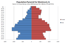
The population was spread out with 21.9% under the age of 18, 8.3% from 18 to 24, 33.8% from 25 to 44, 20.3% from 45 to 64, and 15.7% who were 65 years of age or older. The median age was 36 years. For every 100 females there were 87.4 males. For every 100 females age 18 and over, there were 82.9 males.
The median income for a household in the village was $51,422, and the median income for a family was $64,472. Males had a median income of $42,909 versus $33,690 for females. The per capita income for the village was $26,394. About 3.8% of families and 5.8% of the population were below the poverty line, including 4.8% of those under age 18 and 8.5% of those age 65 or over.
Transportation
Westmont has a Westmont Metra station on Metra's BNSF Railway Line, which provides daily rail service between Aurora, Illinois and Chicago, Illinois (at Union Station). U.S. Route 34, Interstate 88 located north of the Village, Interstate 55 to the South, Interstate 294 to the East and Interstate 355 to the West, provide access to the rest of the Chicago Region.
See also
References
- ↑ "westmont il - Wolfram-Alpha".
- ↑ 2000 United States Census Data
- ↑ "Westmont (village) QuickFacts from the US Census Bureau".
- 1 2 3 4 5 Village of Westmont. "History of Westmont". Retrieved 2 August 2014.
- ↑ "US Gazetteer files: 2010, 2000, and 1990". United States Census Bureau. 2011-02-12. Retrieved 2011-04-23.
- ↑ "G001 - Geographic Identifiers - 2010 Census Summary File 1". United States Census Bureau. Retrieved 2015-12-25.
- ↑ "Annual Estimates of the Resident Population for Incorporated Places: April 1, 2010 to July 1, 2015". Retrieved July 2, 2016.
- ↑ "Census of Population and Housing". Census.gov. Retrieved June 4, 2015.
- ↑ "American FactFinder". United States Census Bureau. Retrieved 2008-01-31.
7. http://www.idcide.com/citydata/il/westmont.htm
External links
- Westmont Chamber of Commerce and Tourism Bureau
- Westmont Adventist Church and School
- Map and Data from Wolfram Alpha
Municipalities and communities of DuPage County, Illinois, United States | ||
|---|---|---|
| Cities | ||
| Villages |
| |
| Townships | ||
| Unincorporated communities | ||
| Ghost towns | ||
| Footnotes | ‡This populated place also has portions in an adjacent county or counties | |
| Major city |  | |
|---|---|---|
| Cities (over 30,000 in 2010) | ||
| Towns and villages (over 30,000 in 2010) |
| |
| Counties | ||
| Regions | ||
| Sub-regions | ||
