Merrillville, Indiana
| Town of Merrillville, Indiana | ||
|---|---|---|
| Town | ||
|
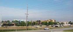
Merrillville Skyline | ||
| ||
 Location in the state of Indiana | ||
| Coordinates: 41°29′8″N 87°20′7″W / 41.48556°N 87.33528°WCoordinates: 41°29′8″N 87°20′7″W / 41.48556°N 87.33528°W | ||
| Country | United States | |
| State | Indiana | |
| County | Lake | |
| Township | Ross | |
| Government | ||
| • Type | Town | |
| Area[1] | ||
| • Total | 33.26 sq mi (86.14 km2) | |
| • Land | 33.22 sq mi (86.04 km2) | |
| • Water | 0.04 sq mi (0.10 km2) | |
| Elevation | 656 ft (200 m) | |
| Population (2010)[2] | ||
| • Total | 35,246 | |
| • Estimate (2012[3]) | 35,631 | |
| • Density | 1,061.0/sq mi (409.7/km2) | |
| Time zone | CST (UTC-6) | |
| • Summer (DST) | CDT (UTC-5) | |
| ZIP codes | 46410, 46411, 46342(Partial) | |
| Area code(s) | 219 | |
| FIPS code | 18-48528[4] | |
| GNIS feature ID | 0439028[5] | |
| Website | www.merrillville.in.gov | |

Merrillville /ˈmɛrəlvɪl/ is a town in Ross Township, Lake County, Indiana. The population was 35,246 at the 2010 census. Merrillville is located in the east-central portion of Lake County, in the Chicago metropolitan area. On January 1, 2015, Merrillville became the most populated town in Indiana, as Fishers in Hamilton County was converted from a town to a city.
Geography
.JPG)
Merrillville is located at 41°29′08″N 87°20′07″W / 41.485669°N 87.335390°W.[6]
According to the 2010 census, Merrillville has a total area of 33.26 square miles (86.14 km2), of which 33.22 square miles (86.04 km2) (or 99.88%) is land and 0.04 square miles (0.10 km2) (or 0.12%) is water.[1]
The town is centered on the intersection of U.S. Route 30 and Interstate 65.
The Lincoln Highway runs through Merrillville. The original alignment of Lincoln Highway is known as 73rd Avenue (also called Old Lincoln Highway) in Merrillville, while the current Lincoln Highway (US 30) is known as 81st Avenue. State Road 53 (Broadway) and State Road 55 (Taft Street) traverse the town from north to south.
The asymmetric shape of Merrillville results in numerous boundaries with other municipalities. Merrillville is bordered by Gary and unincorporated Calumet Township, Lake County, to the north; Hobart to the northeast; Union Township, Porter County, to the east; Winfield and Crown Point to the south; Schererville to the west; and Griffith to the northwest.
| Merrillville | ||||||||||||||||||||||||||||||||||||||||||||||||||||||||||||
|---|---|---|---|---|---|---|---|---|---|---|---|---|---|---|---|---|---|---|---|---|---|---|---|---|---|---|---|---|---|---|---|---|---|---|---|---|---|---|---|---|---|---|---|---|---|---|---|---|---|---|---|---|---|---|---|---|---|---|---|---|
| Climate chart (explanation) | ||||||||||||||||||||||||||||||||||||||||||||||||||||||||||||
| ||||||||||||||||||||||||||||||||||||||||||||||||||||||||||||
| ||||||||||||||||||||||||||||||||||||||||||||||||||||||||||||
History
Merrillville is located on what used to be woodland that belonged to the Potawatomi Indians. In 1834, a clearing was created for ceremonial purposes and was called McGwinn Village. A year later, a white man by the name of Jeremiah Wiggins settled in the place; McGwinn Village thus gave way to Wiggins Point.[7]
Under the name Wiggins Point, the place became a well-known stop for wagon trains heading to Joliet, Illinois along the old Sauk Trail (also called the Sac Trail), which was an old Indian trail. At one time, 16 trails radiated outward from Wiggins Point. In 1838, Wiggins died. Sometime afterwards, local settlers renamed the place Centerville. Later still, it was renamed Merrillville after the brothers Dudley and William Merrill.[7] Dudley Merrill operated a hotel and store in Centerville, and his son John P. Merrill was a Township Trustee.[8]
Nearby, in the same former hunting grounds of the Potawatomi Indians, other settlements had sprung up. Near Deep River creek was a settlement named Deep River; near Turkey Creek was another settlement with that creek's name. Other settlements included Ainsworth, Lottaville, and Rexville. At one time, the post office for the area was named Lottaville.
In 1848, all of these settlements, including Merrillville (that is, the old McGwinn Village) were collected into one and called Ross Township. As time went by, bits and pieces of Ross Township were taken by Hobart and Crown Point when those towns incorporated.
In 1971, the area officially became Merrillville (which now includes the old Merrillville as well as other settlements nearby) and was incorporated as a town under Indiana law.[7] During this time, the majority of the town's growth was due to white flight from Gary.[9]
In 1993, Merrillville tried to annex unincorporated Winfield Township to get more land. The residents blocked Merrillville by creating the town of Winfield.[10]

In 2009, a pedestrian bridge at Hidden Lake Park collapsed, injuring at least 25 people. [11] [12] The catastrophe occurred around 10 PM after the annual Fourth of July fireworks display,[13] when several dozen people attempted to cross the wood suspension bridge.[14] Police officers stationed at either side of the bridge were unable to stop the advancing parkgoers, and with numerous people jumping up and down the 30-year-old bridge collapsed, sending somewhere around 50 people into the waters of Hidden Lake.
The Morgan-Skinner-Boyd Homestead and John Wood Old Mill are listed in the National Register of Historic Places.[15][16]
Economy
Merrillville is a hub for retail trade in Northwest Indiana. The US 30 corridor between Taft Street and Colorado Street harbors a large concentration of big-box retailers, hotels, restaurants, and automobile dealerships.
Ameriplex at the Crossroads, an industrial and technology park, opened at Broadway between 93rd Avenue and 101st Avenue in 2005. The development is designated an Indiana Certified Technology Park and includes two Purdue University related facilities: Purdue University Calumet's Academic Learning Center and a business incubator/technology center operated by the Purdue Research Foundation.
Heavy industry such as steelmaking and petroleum refining that characterizes the economy of northern Lake County does not have a significant presence in Merrillville.
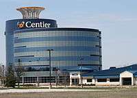
The town is home to the corporate headquarters of NiSource, a Fortune 500 company, and of Centier Bank, the largest privately owned independent bank in Indiana.[17]
Merrillville's nearest commercial airports are Griffith-Merrillville Airport in Griffith and Gary/Chicago International Airport in Gary.
Merrillville is also protected by Indiana's largest volunteer fire department, the Ross Township Fire Service. It maintains over 120 all volunteer firefighters over four stations placed throughout the town.[18][19]
Demographics
| Historical population | |||
|---|---|---|---|
| Census | Pop. | %± | |
| 1880 | 106 | — | |
| 1970 | 15,918 | — | |
| 1980 | 27,677 | 73.9% | |
| 1990 | 27,257 | −1.5% | |
| 2000 | 30,560 | 12.1% | |
| 2010 | 35,246 | 15.3% | |
| Est. 2015 | 35,224 | [20] | −0.1% |
| Source: US Census Bureau. | |||
2010 census
As of the census[2] of 2010, there were 35,246 people, 13,696 households, and 9,016 families residing in the town. The population density was 1,061.0 inhabitants per square mile (409.7/km2). There were 14,842 housing units at an average density of 446.8 per square mile (172.5/km2). The racial makeup of the town was 46.4% White, 44.5% African American, 0.2% Native American, 1.2% Asian, 4.6% from other races, and 3.2% from two or more races. Hispanic or Latino of any race were 12.9% of the population.
There were 13,696 households of which 34.1% had children under the age of 18 living with them, 42.3% were married couples living together, 17.9% had a female householder with no husband present, 5.6% had a male householder with no wife present, and 34.2% were non-families. 29.7% of all households were made up of individuals and 11.8% had someone living alone who was 65 years of age or older. The average household size was 2.54 and the average family size was 3.16.
The median age in the town was 36.7 years. 25.5% of residents were under the age of 18; 8.6% were between the ages of 18 and 24; 26.8% were from 25 to 44; 25.5% were from 45 to 64; and 13.7% were 65 years of age or older. The gender makeup of the town was 47.0% male and 53.0% female.
As of 2010, the median income for a household in the town was $49,469 while the mean income for a household in the town was $57,728. The median income for a family was $56,911 and the mean income for a family was $65,925. The estimated per capita income for the town was $22,993. About 8.9% of families and 12.0% of the population were estimated to be below the poverty line.[21]
2000 census
As of the census[4] of 2000, there were 30,560 people, 11,678 households, and 8,127 families residing in the town. The population density was 918.2 people per square mile (354.5/km²). There were 12,303 housing units at an average density of 369.6/sq mi (142.7/km²). The racial makeup of the town was 69.65% White, 22.86% African American, 0.33% Native American, 1.51% Asian, 0.02% Pacific Islander, 3.39% from other races, and 2.24% from two or more races. Hispanic or Latino of any race were 9.65% of the population.
There were 11,678 households out of which 32.2% had children under the age of 18 living with them, 52.9% were married couples living together, 12.6% had a female householder with no husband present, and 30.4% were non-families. 26.1% of all households were made up of individuals and 11.8% had someone living alone who was 65 years of age or older. The average household size was 2.57 and the average family size was 3.12.
In the town the population was spread out with 24.6% under the age of 18, 8.7% from 18 to 24, 29.4% from 25 to 44, 22.2% from 45 to 64, and 15.1% who were 65 years of age or older. The median age was 37 years. For every 100 females there were 91.2 males. For every 100 females age 18 and over, there were 86.7 males.
The median income for a household in the town was $49,545, and the median income for a family was $56,355. Males had a median income of $41,820 versus $29,005 for females. The per capita income for the town was $22,293. About 2.6% of families and 4.3% of the population were below the poverty line, including 4.1% of those under age 18 and 5.5% of those age 65 or over.
Transportation
Gary Public Transportation Corporation provides bus service along Broadway Avenue corridor and within the US 30 retail/office corridor. Those routes are partially funded by Northwest Indiana Regional Bus Authority. The closest South Shore Line station is located in downtown Gary and can be reached using GPTC Route 17. The closest Amtrak station is located in Dyer, Indiana. It cannot be directly reached by public transit as of this writing.
Education
Public education in the town is provided by the Merrillville Community School Corporation. Andrean High School, a Roman Catholic institution operated by the Diocese of Gary, is also located in Merrillville.
Lake County Public Library operates the Central Library at 1919 West 81st Avenue in Merrillville.[22]
References
- 1 2 "G001 - Geographic Identifiers - 2010 Census Summary File 1". United States Census Bureau. Retrieved 2015-07-17.
- 1 2 "American FactFinder". United States Census Bureau. Retrieved 2012-12-11.
- ↑ "Population Estimates". United States Census Bureau. Archived from the original on 2013-06-17. Retrieved 2013-06-25.
- 1 2 "American FactFinder". United States Census Bureau. Archived from the original on 2013-09-11. Retrieved 2008-01-31.
- ↑ "US Board on Geographic Names". United States Geological Survey. 2007-10-25. Retrieved 2008-01-31.
- ↑ "US Gazetteer files: 2010, 2000, and 1990". United States Census Bureau. 2011-02-12. Retrieved 2011-04-23.
- 1 2 3 Archived September 23, 2006, at the Wayback Machine.
- ↑ "Dudley Y. Merrill (1814-1890)". Lowellpl.lib.in.us. 2008-03-22. Archived from the original on 2016-02-03. Retrieved 2015-09-07.
- ↑ "Merrillville, IN". Encyclopedia of Chicago. Chicago Historical Society. Archived from the original on 26 June 2012. Retrieved 2 May 2012.
- ↑ "Annexation Diary". The Times of Northwest Indiana. Retrieved 2015-07-17.
- ↑
- ↑
- ↑
- ↑
- ↑ National Park Service (2010-07-09). "National Register Information System". National Register of Historic Places. National Park Service.
- ↑ "National Register of Historic Places Listings". Weekly List of Actions Taken on Properties: 12/27/10 through 12/30/10. National Park Service. 2011-01-07.
- ↑ "Message From Mike". Centier. 2012-10-22. Retrieved 2015-09-07.
- ↑ "Homepage". Lake County Website. CountyWebsite.com. Retrieved 2 May 2012.
- ↑ "Merrillville Volunteer Fire Department". Indiana Fire Trucks. Indiana Fire Trucks. Retrieved 2 May 2012.
- ↑ "Annual Estimates of the Resident Population for Incorporated Places: April 1, 2010 to July 1, 2015". Retrieved July 2, 2016.
- ↑ "SELECTED ECONOMIC CHARACTERISTICS : 2008-2010 American Community Survey 3-Year Estimates". Factfinder2.census.gov. Retrieved 2015-09-07.
- ↑ "Lake County Indiana Public Library Events Programs Kids Books Teens". Lcplin.org. Retrieved 2015-09-07.
External links
- Official website
- Merrillville Historical Society website
- Merrillville Chamber of Commerce
- Merrillville Alumni Web Site - home for alumni of Merrillville High School
- Andrean High School
Municipalities and communities of Lake County, Indiana, United States | ||
|---|---|---|
| Cities | ||
| Towns | ||
| Townships | ||
| CDPs | ||
| Other unincorporated communities |
| |
| Ghost towns |
| |
| Footnotes | ‡This populated place also has portions in an adjacent county or counties | |
| Major city | 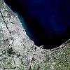 | |
|---|---|---|
| Cities (over 30,000 in 2010) | ||
| Towns and villages (over 30,000 in 2010) |
| |
| Counties | ||
| Regions | ||
| Sub-regions | ||
