Alberta Highway 45

Alberta Highway 45 shield

Highway 45
Route information
Length: 231 km (144 mi)
Major junctions
West end: Hwy 15 south of Bruderheim
  Hwy 38 north of Bruderheim
Hwy 29 near Hairy Hill
Hwy 36 at Two Hills
Hwy 41 east of Derwent
Hwy 17 north of Lloydminster
East end: Saskatchewan border
continues as Hwy 3
Location
Specialized
and rural
municipalities:
Lamont County, County of Two Hills No. 21, County of Vermilion River
Towns: Bruderheim, Two Hills
Villages: Willingdon, Myrnam, Marwayne
Highway system

Provincial highways in Alberta

Hwy 44Hwy 47

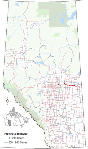
Alberta Provincial Highway No. 45[1] is an east-west highway in central Alberta, Canada. It extends from Highway 15 northeast of Edmonton to the Saskatchewan border. It runs generally parallel to Highway 16 (Yellowhead Highway).

Major intersections

From west to east:[2]

Rural/specialized municipalityLocationkm[3]miDestinationsNotes
Lamont County00.0 Hwy 15 Lamont, Mundare, Fort Saskatchewan, EdmontonHwy 45 begins
53°46′26.83″N 112°55′33.95″W / 53.7741194°N 112.9260972°W / 53.7741194; -112.9260972
Bruderheim3.22.048 Street / 52 AvenueHwy 45 branches east, then turns north
53°48′13.18″N 112°55′34.72″W / 53.8036611°N 112.9263111°W / 53.8036611; -112.9263111
169.9 Hwy 38 west RedwaterHwy 45 branches east
53°53′23.30″N 112°52′33.45″W / 53.8898056°N 112.8759583°W / 53.8898056; -112.8759583
2314 Hwy 831 Lamont, Waskatenau, Boyle53°53′07.09″N 112°50′11.24″W / 53.8853028°N 112.8364556°W / 53.8853028; -112.8364556
3220Range Road 184 – St. Michael53°53′26.4″N 112°37′43.4″W / 53.890667°N 112.628722°W / 53.890667; -112.628722
4427 Hwy 855 north / Range Road 173 Wostok, Smoky LakeHwy 855 concurrency begins
53°53′24.4″N 112°27′19.8″W / 53.890111°N 112.455500°W / 53.890111; -112.455500
Andrew5232 Hwy 855 south (50 Street) MundareHwy 855 concurrency ends
53°53′19.65″N 112°19′53.73″W / 53.8887917°N 112.3315917°W / 53.8887917; -112.3315917
5735 Hwy 645 east53°53′19.28″N 112°15′27.80″W / 53.8886889°N 112.2577222°W / 53.8886889; -112.2577222
County of Two Hills No. 216742 Hwy 857 north BellisHwy 857 concurrency begins
53°49′36.08″N 112°12′16.00″W / 53.8266889°N 112.2044444°W / 53.8266889; -112.2044444
Willingdon684250 Street53°53′46.01″N 113°51′13.67″W / 53.8961139°N 113.8537972°W / 53.8961139; -113.8537972
7345 Hwy 857 south VegrevilleHwy 857 concurrency ends
53°48′08.25″N 112°03′32.69″W / 53.8022917°N 112.0590806°W / 53.8022917; -112.0590806
7748 Hwy 29 west LamontHwy 29 concurrency begins
53°46′31.42″N 112°00′55.40″W / 53.7753944°N 112.0153889°W / 53.7753944; -112.0153889
7848UAR 150 south – Hairy Hill53°46′18.92″N 111°59′04.67″W / 53.7719222°N 111.9846306°W / 53.7719222; -111.9846306
8452 Hwy 29 east St. PaulHwy 29 concurrency ends
53°46′14.97″N 111°53′15.21″W / 53.7708250°N 111.8875583°W / 53.7708250; -111.8875583
Two Hills9760 Hwy 36 south (51 Street) VikingHwy 36 concurrency begins
53°42′38.29″N 111°45′56.97″W / 53.7106361°N 111.7658250°W / 53.7106361; -111.7658250
10062 Hwy 36 north St. Paul, Lac La BicheHwy 36 concurrency ends
53°42′51.88″N 111°41′16.20″W / 53.7144111°N 111.6878333°W / 53.7144111; -111.6878333
Musidora10867Main Street53°41′18.4″N 111°35′3.6″W / 53.688444°N 111.584333°W / 53.688444; -111.584333
Morecambe11672 Hwy 870 south Innisfree53°39′57.0″N 111°27′39.4″W / 53.665833°N 111.460944°W / 53.665833; -111.460944
Beauvallon123761st Street53°39′27.9″N 111°21′55.4″W / 53.657750°N 111.365389°W / 53.657750; -111.365389
Myrnam13383 Hwy 881 (50 Street) Mannville, St. Paul53°39′55.62″N 111°27′51.91″W / 53.6654500°N 111.4644194°W / 53.6654500; -111.4644194
Derwent15194UAR 155 south53°39′23.32″N 111°05′44.37″W / 53.6564778°N 111.0956583°W / 53.6564778; -111.0956583
15798 Hwy 41 north Elk Point, BonnyvilleHwy 45 branches south
Hwy 41 concurrency begins
53°39′23.13″N 110°52′05.39″W / 53.6564250°N 110.8681639°W / 53.6564250; -110.8681639
164102 Hwy 41 south Vermilion, WainwrightHwy 45 branches east
Hwy 41 concurrency ends
53°35′54.72″N 110°52′00.09″W / 53.5985333°N 110.8666917°W / 53.5985333; -110.8666917
County of Vermilion River174108UAR 57 south – Clandonald53°35′55.44″N 110°43′24.39″W / 53.5987333°N 110.7234417°W / 53.5987333; -110.7234417
186116 Hwy 893 south IslayHwy 893 concurrency begins
53°35′56.4″N 110°32′48.0″W / 53.599000°N 110.546667°W / 53.599000; -110.546667
Dewberry188117 Hwy 893 north / UAR 56 south HeinsburgHwy 893 concurrency ends
53°35′55.13″N 110°32′45.30″W / 53.5986472°N 110.5459167°W / 53.5986472; -110.5459167
202126 Hwy 897 north Frog Lake, Cold LakeHwy 45 branches south
Hwy 897 concurrency begins
53°35′34.65″N 110°21′16.65″W / 53.5929583°N 110.3546250°W / 53.5929583; -110.3546250
Marwayne210130 Hwy 897 south KitscotyHwy 45 turns east
Hwy 897 concurrency ends
53°30′52.37″N 110°19′27.44″W / 53.5145472°N 110.3242889°W / 53.5145472; -110.3242889
231144 Hwy 17 Onion Lake, Lloydminster
AlbertaSaskatchewan border
Hwy 45 ends
53°30′39.33″N 110°00′17.23″W / 53.5109250°N 110.0047861°W / 53.5109250; -110.0047861
Continues as Hwy 3 east Paradise Hill, St. Walburg, Prince Albert
1.000 mi = 1.609 km; 1.000 km = 0.621 mi

References

  1. Provincial Highways Designation Order, Alberta Transportation, p. 8
  2. Alberta Road Atlas (2005 ed.). Oshawa, ON: MapArt Publishing Corp. pp. 57-59.
  3. "Highway 45" (Map). Google Maps. Google. Retrieved November 17, 2016.

External links

This article is issued from Wikipedia - version of the 12/1/2016. The text is available under the Creative Commons Attribution/Share Alike but additional terms may apply for the media files.