Alberta Highway 88
| ||||
|---|---|---|---|---|
| Bicentennial Highway | ||||
 | ||||
| Route information | ||||
| Length: | 428.4 km[1] (266.2 mi) | |||
| Major junctions | ||||
| South end: |
| |||
| North end: |
| |||
| Location | ||||
| Specialized and rural municipalities: | Lesser Slave River No. 124 M.D., Northern Sunrise County, Opportunity No. 17 M.D., Mackenzie County | |||
| Towns: | Slave Lake | |||
| Highway system | ||||
|
Provincial highways in Alberta
| ||||
.png)
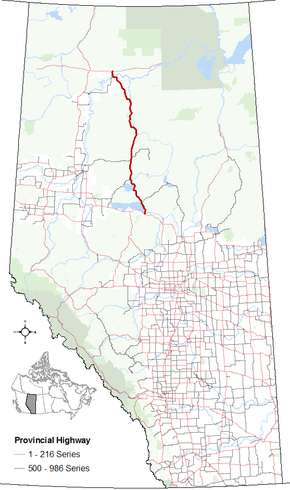
Alberta Provincial Highway No. 88, also named Bicentennial Highway, is a north-south highway in northern Alberta, Canada.[2]
In the south, Highway 88 begins at its intersection with Highway 2 at the Town of Slave Lake, passing through Red Earth Creek and Fort Vermilion and ending at Highway 58 approximately 57 km (35 mi) east of the Town of High Level. It crosses the Peace River approximately 13 km (8.1 mi) south of Highway 58. The total length of the highway is 428 km (266 mi).[1][3]
History
Highway 88 was originally numbered as Highway 67. It was renumbered to Highway 88 and labeled as Bicentennial Highway in 1988 in celebration of 200 years history of Fort Vermilion – one of two communities that claim to be the first European settlement in Alberta (the other being Fort Chipewyan on Lake Athabasca to the east).
Major intersections
From south to north:
| Municipality | km | Description | |||
|---|---|---|---|---|---|
| Town of Slave Lake | 0 | Starts at | |||
| Municipal District of Opportunity No. 17 | 34 | Highway 754 branches east towards Wabasca | |||
| Northern Sunrise County | 111 | Highway 750 branches southwest towards High Prairie | |||
| 159 | Highway 986 branches west towards Peace River | ||||
| Municipal District of Opportunity No. 17 | 169 | Highway 686 branches east at Red Earth Creek and Red Earth Creek Airport | |||
| Mackenzie County | 408 | Passes through Fort Vermilion | |||
| 412 | Highway 697 branches southwest | ||||
| 414 | Crosses Peace River | ||||
| 430 | Ends at Highway 58 | ||||
| 1.000 mi = 1.609 km; 1.000 km = 0.621 mi | |||||
References
- 1 2 "2015 Provincial Highway 1-216 Progress Chart" (PDF). Alberta Transportation. March 2015. Archived (PDF) from the original on April 10, 2016. Retrieved October 31, 2016.
- ↑ Provincial Highways Designation Order, Alberta Transportation, p. 10
- ↑ Google (October 31, 2016). "Highway 78 in northern Alberta" (Map). Google Maps. Google. Retrieved October 31, 2016.
External links
- 2010 Provincial Highways 1 - 216 Series Progress Chart (map, 8 MB) by Alberta Transportation.