Alberta Highway 22
| ||||
|---|---|---|---|---|
| Cowboy Trail | ||||
 | ||||
| Route information | ||||
| Length: | 584 km (363 mi) | |||
| Major junctions | ||||
| From: |
| |||
|
| ||||
| To: |
| |||
| Location | ||||
| Specialized and rural municipalities: | Pincher Creek No. 9 M.D., Ranchland No. 26 M.D., Foothills No. 31 M.D., Rocky View County, Mountain View County, Clearwater County, Wetaskiwin No. 10 County, Brazeau County, Parkland County, Yellowhead County, Lac Ste. Anne County | |||
| Towns: | Black Diamond, Turner Valley, Cochrane, Sundre, Rocky Mountain House, Drayton Valley, Mayerthorpe | |||
| Villages: | Longview, Cremona, Caroline | |||
| Highway system | ||||
|
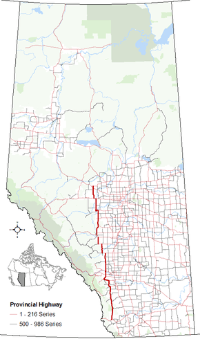
Provincial highways in Alberta
| ||||

.svg.png)
Alberta Provincial Highway No. 22[1] is a north-south highway in Alberta, Canada. The highway has been billed as the Cowboy Trail, since it passes through a lot of ranch country. The highway generally follows the eastern slopes of the Rocky Mountains.
Highway 22 starts at the Crowsnest Highway (Highway 3) between Pincher Creek and the Crowsnest Pass. It then goes north through Longview, Black Diamond, Turner Valley, and Millarville. The highway then jogs west at Highway 22X. About 30 km (19 mi) later, it turns north again and passes through the Hamlet of Bragg Creek where Highway 22X ends. Highway 22 continues north past the Trans-Canada Highway (Highway 1) west of Calgary, north through the Town of Cochrane, the Hamlet of Cochrane Lake, and the Village of Cremona to Highway 27.
The highway continues in a generally northward direction (with a number of westward jogs), passing through Sundre, Caroline, Rocky Mountain House and Drayton Valley until it intersects Highway 16 (Yellowhead Highway) at Entwistle approximately 85 km (53 mi) west of Edmonton). After a 8 km (5.0 mi) jog to the west, it continues north to cross Highway 43 at Town of Mayerthorpe, where it terminates 7 km north of the town at Highway 18.
In 1955 a ferry was built to cross the North Saskatchewan River.[2] A bridge was eventually built to replace a ferry that crossed the river. In 2014, at the cost of C$52 million, a new bridge was completed.[3][4]
Major intersections
From south to north:[5]
| Rural/specialized municipality | Location | km | mi | Destinations | Notes |
|---|---|---|---|---|---|
| M.D. of Pincher Creek No. 9 | Lundbreck | 0 | 0.0 | South terminus of Hwy 22 | |
| | 24 | 15 | Crosses Oldman River | ||
| M.D. of Ranchland No. 66 | | 44 | 27 | ||
| Chain Lakes Provincial Park | 71 | 44 | Park Access Road 152 east | ||
| | 82 | 51 | |||
| M.D. of Foothills No. 31 | Bar U Ranch N.H.S. | 96 | 60 | ||
| Longview | 109 | 68 | Crosses the Highwood River | ||
| 111 | 69 | ||||
| | 118 | 73 | |||
| Black Diamond | 128 | 80 | Hwy 22 branches west | ||
| ↑ / ↓ | 129 | 80 | Crosses the Sheep River | ||
| Turner Valley | 132 | 82 | |||
| Millarville | 143 | 89 | Hwy 549 concurrency begins | ||
| | 146 | 91 | Hwy 549 concurrency ends | ||
| Priddis | 159 | 99 | Hwy 22 branches west | ||
| | 184.7 | 114.8 | |||
| ↑ / ↓ | | 185 | 115 | Hwy 22 branches north | |
| Rocky View County | Bragg Creek | 189 | 117 | Hwy 22 branches northeast | |
| Tsuu T'ina Nation I.R. No. 145 | Redwood Meadows | 195 | 121 | Redwood Meadows Drive | |
| Rocky View County | | 199 | 124 | Roundabout Hwy 22 turns north | |
| | 207 | 129 | Interchange | ||
| Cochrane | 214 | 133 | James Walker Trail / Fireside Gate | ||
| 217 | 135 | Crosses the Bow River | |||
| 219 | 136 | ||||
| | 228 | 142 | Roundabout | ||
| Bottrel | 244 | 152 | |||
| Mountain View County | | 255 | 158 | ||
| Cremona | 259 | 161 | |||
| | 274 | 170 | |||
| | 286 | 178 | Hwy 22 branches west Hwy 27 concurrency begins | ||
| Westward Ho | 288 | 179 | Crosses the Little Red Deer River | ||
| Sundre | 296 | 184 | |||
| 296.3 | 184.1 | Crosses the Red Deer River | |||
| 298 | 185 | Hwy 22 branches north Hwy 27 concurrency ends | |||
| ↑ / ↓ | | 310 | 190 | Crosses the James River | |
| Clearwater County | James River Bridge | 315 | 196 | ||
| | 327 | 203 | Crosses the Raven River | ||
| | 332 | 206 | Hwy 22 branches west Hwy 54 concurrency begins | ||
| Caroline | 337 | 209 | 50 Street | ||
| | 344.8 | 214.2 | Crosses the Clearwater River | ||
| | 345 | 214 | Hwy 22 branches north Hwy 54 concurrency ends | ||
| | 360 | 220 | Crosses the Clearwater River | ||
| | 371 | 231 | Hwy 22 branches west Hwy 11 concurrency begins | ||
| Rocky Mountain House | 379 | 235 | 52 Avenue | Access to Rocky Mountain House National Historic Site. | |
| 383 | 238 | Hwy 22 branches north Hwy 11 concurrency ends | |||
| | 389 | 242 | |||
| | 416 | 258 | |||
| County of Wetaskiwin No. 10 | | 443 | 275 | ||
| Brazeau County | | 463 | 288 | ||
| | 474 | 295 | Hwy 22 branches west | ||
| | 480 | 300 | Crosses the North Saskatchewan River | ||
| | 485 | 301 | Hwy 22 turns north | ||
| Drayton Valley | 488 | 303 | 50 Avenue | ||
| 490 | 300 | 50 Street | |||
| Rocky Rapids | 495 | 308 | |||
| ↑ / ↓ | | 505 | 314 | ||
| Parkland County | Entwistle | 530 | 330 | Interchange Hwy 22 branches west Hwy 16 concurrency begins | |
| ↑ / ↓ | ↑ / ↓ | 532 | 331 | Crosses the Pembina River | |
| Yellowhead County | Evansburg | 533 | 331 | Urban Approach Road 115 north | |
| | 538 | 334 | Hwy 22 branches north Hwy 16 concurrency ends | ||
| | 539 | 335 | |||
| Lac Ste. Anne County | | 571 | 355 | ||
| Mayerthorpe | 577 | 359 | |||
| | 584 | 363 | North terminus of Hwy 22 | ||
1.000 mi = 1.609 km; 1.000 km = 0.621 mi
| |||||
References
- ↑ Provincial Highways Designation Order, Alberta Transportation, p. 5
- ↑ Martin, Isobel (1977). Forests to Grainfields. Berrymoor, Alberta: Berrymoor/Carnwood Historical Society. p. 133. ISBN 0-919213-36-7.
- ↑ http://www.flatironcorp.com/index.asp?w=pages&r=5&pid=26&project=150
- ↑ http://bigwestcountry.ca/2015/06/bridge-open-to-traffic/
- ↑ Alberta Road Atlas (2005 ed.). Oshawa, ON: MapArt Publishing Corp. pp. 55, 63, 69, 70, 75, 76, and 82.
External links
| Wikimedia Commons has media related to Alberta Highway 22. |
- 2010 Provincial Highways 1 - 216 Series Progress Chart (map, 8 MB) by Alberta Transportation.
- The Cowboy Trail's official webpage