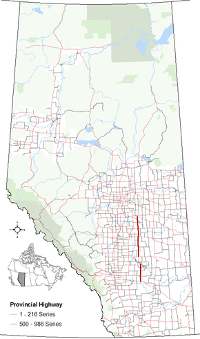
Alberta Highway 56

Alberta Highway 56 shield

Highway 56
Route information
Length: 247 km (153 mi)
Major junctions
North end: Hwy 13 / Hwy 834 southeast of Camrose
  Hwy 53 west of Donalda
Hwy 12 in Stettler
Hwy 9 / Hwy 27 east of Morrin
Hwy 10 at Rosedale
South end: Hwy 1 (TCH) (Trans-Canada Highway) near Bassano
Location
Specialized
and rural
municipalities:
Wheatland County, Starland County, Stettler No. 6 County, Camrose County
Towns: Stettler, Drumheller
Highway system

Provincial highways in Alberta

Hwy 55Hwy 58

Alberta Provincial Highway No. 56[1] is a north-south highway in central Alberta, Canada. It begins 20 km (12 mi) northwest of the Town of Bassano at its intersection with Highway 1 (Trans-Canada Highway). It continues through Drumheller and Stettler and before ending at intersection with Highway 13 and Highway 834 9 km (5.6 mi) southeast of the City of Camrose.

Intersection of Highway 56 and Highway 10

History

In the early 1990s, there was talk of extending Highway 56 from the Highway 1 to the US border. This was due in large part to then Alberta Premier Don Getty, who at the time was also the MLA for Stettler. All talk of this endeavor stopped once Getty retired from politics and was succeeded as Premier by Ralph Klein.

Major intersections

Starting from the south end of Highway 56:

Rural/specialized municipalityLocationkm[2]miDestinationsNotes
Continues as Range Road 201 south towards Crowfoot Ferry
Wheatland County00.0 Hwy 1 (TCH) Bassano, Medicine Hat, CalgaryHwy 56 begins
50°50′03″N 112°39′31″W / 50.83421°N 112.65870°W / 50.83421; -112.65870 (56 x 1)
2012 Hwy 561 eastHwy 561 concurrency begins
51°00′32″N 112°39′22″W / 51.00879°N 112.65600°W / 51.00879; -112.65600 (56 x 561_east)
Hussar2314 Hwy 561 west StandardHwy 561 concurrency ends
51°02′16″N 112°39′06″W / 51.03767°N 112.65179°W / 51.03767; -112.65179 (56 x 561_west)
4025 Hwy 56451°11′00″N 112°37′59″W / 51.18337°N 112.63299°W / 51.18337; -112.63299 (56 x 564)
Dalum5333 Hwy 56951°17′59″N 112°37′50″W / 51.29963°N 112.63046°W / 51.29963; -112.63046 (56 x 569)
Town of Drumheller6540 Hwy 10 east East CouleeHwy 56 branches northwest
Hwy 10 concurrency begins
51°24′31″N 112°37′03″W / 51.40851°N 112.61759°W / 51.40851; -112.61759 (56 x 10)
Rosedale6641 Hwy 10X south Wayne51°25′02″N 112°37′49″W / 51.417177°N 112.630334°W / 51.417177; -112.630334 (56 x 10X)
Drumheller
(Townsite)
7345 Hwy 9 west / 5 Street SE Beiseker, CalgaryHwy 10 concurrency ends
Hwy 9 concurrency begins
51°27′28″N 112°42′03″W / 51.457913°N 112.700700°W / 51.457913; -112.700700 (56 x 9_west)
74462 Street SW
Hwy 575 west (South Dinosaur Trail) Nacmine, Carbon
Hwy 9/56 branches north
51°27′43″N 112°42′39″W / 51.461864°N 112.710785°W / 51.461864; -112.710785 (56 x 575)
74.546.3Crosses Red Deer River51°28′04″N 112°42′43″W / 51.467779°N 112.712040°W / 51.467779; -112.712040 (Red Deer River)
7547 Hwy 838 west (North Dinosaur Trail) Royal Tyrrell Museum51°28′17″N 112°42′44″W / 51.471466°N 112.712245°W / 51.471466; -112.712245 (56 x 838)
7647 Hwy 576 east51°28′26″N 112°42′55″W / 51.473865°N 112.715306°W / 51.473865; -112.715306 (56 x 576)
Starland CountyMunson8553Township Road 30251°33′48″N 112°43′26″W / 51.563234°N 112.723884°W / 51.563234; -112.723884 (56 x Munson)
9559 Hwy 9 east Hanna, Saskatoon
Hwy 27 west Morrin, Three Hills
Hwy 9 concurrency ends.
51°38′56″N 112°43′18″W / 51.648989°N 112.721557°W / 51.648989; -112.721557 (56 x 27 x 9_east)
11873 Hwy 585 Rumsey, Trochu51°51′10″N 112°43′18″W / 51.85264°N 112.72153°W / 51.85264; -112.72153 (56 x 585)
County of Stettler No. 613181 Hwy 589 east Byemoor51°58′07″N 112°43′09″W / 51.96872°N 112.71930°W / 51.96872; -112.71930 (56 x 589)
Big Valley13886 Hwy 590 east Innisfail51°58′07″N 112°43′09″W / 51.96872°N 112.71930°W / 51.96872; -112.71930 (56 x 590)
14087UAR 55 west52°02′28″N 112°43′10″W / 52.040974°N 112.719322°W / 52.040974; -112.719322 (56 x UAR55)
15798 Hwy 594 west52°12′04″N 112°43′09″W / 52.20115°N 112.71925°W / 52.20115; -112.71925 (56 x 594)
Town of Stettler171106 Hwy 12 Lacombe, Red Deer, Coronation, Consort52°19′24″N 112°43′09″W / 52.323378°N 112.719272°W / 52.323378; -112.719272 (56 x 12)
171.5106.651 AvenueHwy 56 branches east
52°19′38″N 112°42′56″W / 52.327345°N 112.715626°W / 52.327345; -112.715626 (56 x 51 Ave)
17210746 StreetHwy 56 branches north
52°19′40″N 112°41′58″W / 52.327642°N 112.699317°W / 52.327642; -112.699317 (56 x 46 St)
County of Stettler No. 6182113 Hwy 601 Red Willow, Buffalo Lake, Alix52°24′18″N 112°41′30″W / 52.40491°N 112.69175°W / 52.40491; -112.69175 (56 x 601)
↑ / ↓201125 Hwy 53 east Donalda, Forestburg, Bashaw, Ponoka52°34′47″N 112°41′30″W / 52.57967°N 112.69179°W / 52.57967; -112.69179 (Highway 53)
Camrose CountyMeeting Creek213132UAR 210 west52°40′41″N 112°42′57″W / 52.67817°N 112.71594°W / 52.67817; -112.71594 (56 x UAR210)
225140 Hwy 609 west Edberg, FerintoshHwy 609 concurrency begins
52°47′05″N 112°42′48″W / 52.78463°N 112.71342°W / 52.78463; -112.71342 (56 x 609_west)
226140Crosses Battle River52°47′16″N 112°42′47″W / 52.78785°N 112.71303°W / 52.78785; -112.71303 (Battle River)
228142 Hwy 609 east RosalindHwy 609 concurrency ends
52°48′49″N 112°42′47″W / 52.81351°N 112.71303°W / 52.81351; -112.71303 (56 x 609_east)
247153 Hwy 13 Camrose, Wetaskiwin, Killam, Provost
Hwy 834 north Tofield
Hwy 56 ends; becomes Hwy 834
52°58′50″N 112°42′48″W / 52.98067°N 112.71320°W / 52.98067; -112.71320 (56 x 13 x 834)
251156 Hwy 26 Camrose, Viking53°01′05″N 112°42′48″W / 53.018127°N 112.713277°W / 53.018127; -112.713277 (834 x 26)
1.000 mi = 1.609 km; 1.000 km = 0.621 mi
  •       Closed/former
  •       Concurrency terminus

See also

References

  1. Provincial Highways Designation Order, Alberta Transportation, p. 9
  2. "Google Maps". Google Maps. Retrieved 9 June 2016.

External links

This article is issued from Wikipedia - version of the 11/29/2016. The text is available under the Creative Commons Attribution/Share Alike but additional terms may apply for the media files.